
-
 2014 Hits
-
 77.48% Score
-
 8 Votes
|
|
Route |
|---|---|
|
|
45.51907°N / 7.26607°E |
|
|
Overview
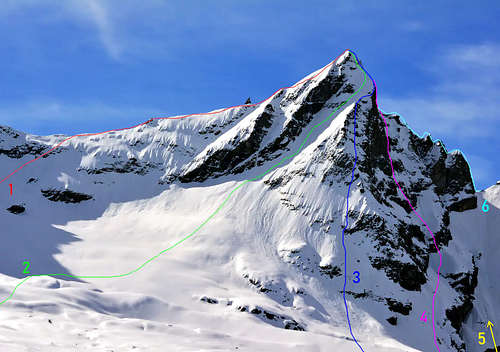
From the Gran Paradiso (4.061m) three main crests descend which with directions North, South and East form a whole series of secondary or satellite peaks. The same, located on the North/South axis, it separates Valsavaranche (to the West) from the Cogne Valley (to the East and then to the North) and constitutes the highest point of this large group of mountains that form the Southern or Southeast Graian Alps. A northern crest descends towards Piccolo Paradiso and then ends at the pyramids of Grivola and Grand Nomenon,with these last two pyramids which are excluded in this work by stopping the analysis at Colle Loson or Lauzon. While the opposite is directed, after having formed the Roc, towards the Becca di Moncorvé; this is the point where it splits, sending a main branch dividing the Valsavara from the Piedmont Region which, forming along the road the Tresenta, the Ciarforon, the Becca di Monciair and the Denti del Broglio, ends at the Colle del Grand Etret Orientale (3.152m). From this side the mountain drops with the beautiful Northwest Face in the first northernmost sector contained by the Glacier de Laveciàu, which a secondary ridge divides from the most southwestern sector covered by the Glacier du Mont Gran Paradis, such as to constitute the Normal Route above of a high and long rocky bastion that joins the Becca di Moncorvé. The route starting from the Vittorio Emanuele II Refuge (2.734m) and the Federico and Renato Chabod Refuge (2.710m) converge on the same road near a snowy hump called "Schiena dell'Asino" ("Donkey's Back or Hump"). A third ridge, no less long and important, starting from the Roc del Gran Paradiso (4.026m), heads eastwards forming the Gastaldi Crest, the Punta di Ceresole, the Teste della Tribolazione, Valnontey and Gran Crou up to the homonymous hill (3.305m), where the border crest heads towards Becca di Gay and Roccia Viva. From this side and above the tormented Tribolazione Glacier, the East Wall descends, formed by a glacial slide alternating with rocky ribs.
Dal Gran Paradiso (4.061 m) scendono tre creste principali che con direzioni Nord, Sud ed Est vanno a formare tutta una serie di cime secondarie o satelliti. Lo stesso, posto sull'asse Nord/Sud, separa la Valsavaranche (ad Ovest) dalla Valle di Cogne (ad Est e poi a Nord) e costituisce il punto maggiormente elevato di questo ampio gruppo di montagne che formano le Alpi Graie Meridionali o di Sudest. Una cresta settentrionale scende verso il Piccolo Paradiso per poi concludersi presso le piramidi della Grivola e del Grand Nomenon, con queste due ultime piramidi che in questo lavoro vengono escluse fermandosi l'analisi al Colle Loson o Lauzon. Mentre l'opposta si indirizza, dopo aver formato il Roc, verso la Becca di Moncorvé; é questo il punto dove la medesima si sdoppia inviando un ramo principale divisorio la Valsavara dalla Regione Piemonte che, formando per strada la Tresenta, il Ciarforon, la Becca di Monciair ed i Denti del Broglio, si conclude al Colle del Grand Etret Orientale (3.152 m). Da questo lato la montagna lascia cadere la bella Parete Nordovest nel primo settore più a Nord contenuto dal Glacier de Laveciàu, che una cresta secondaria divide dal settore più a Sudovest ricoperto dal Glacier du Mont Gran Paradis, tale da costituire la Via Normale al di sopra di una alta e lunga bastionata rocciosa che va a congiungersi con la Becca di Moncorvé. Sulla medesima nei pressi di una gobba nevosa chiamata "Schiena dell'Asino", confluiscono sia la via con partenza dal Rifugio Vittorio Emanuele II (2.734 m) che quella dal Rifugio Federico e Renato Chabod (2.710 m). Una terza cresta, non meno lunga ed importante, partendo dal Roc del Gran Paradiso (4.026 m), si indirizza ad Oriente formando la Cresta Gastaldi, la Punta di Ceresole, le Teste della Tribolazione, di Valnontey e di Gran Crou fino allo omonimo colle (3.305 m), dove la cresta di confine si indirizza verso la Becca di Gay e la Roccia Viva. Da questo lato ed al di sopra del tormentato Ghiacciaio della Tribolazione scende la Parete Est, formata da uno scivolo glaciale alternato a costole rocciose.
Fist Ascents
Tresenta (3.609m)
- First on the Summit: M. Baretti and A. Blanchetti, (1867).
Ciarforon (3.642m)
- First on the Summit: F. Vallino and A. Blanchetti, (Aug 25th, 1871).
Becca di Monciair (3.544m)
- First on the Summit: G. Frasca e G. Blanchetti, (Jul 14th, 1881).
Denti del Broglio (3.454)
- First on the Summit: Rev, W. B. A. Coolidge, Franz Gardiner and mountain guides Christian Jun. Almer and R. Almer, (Aug 08th, 1889).
Il Roc (4.026m)
- First on the Summit: C. Cookson, F. Truffer e L. Jeantet, (Aug 22th, 1894).
Becca di Moncorvè (3.875m)
- First on the Summit: Luigi Vaccarone, (Aug 12th, 1885).
Piccolo Paradiso: (3.926m)
- First on the Summit: P. G. Frassy con E. Jeantet, (Aug 03th, 1869).
Becca di Montandayné (3.838m)
- Firs on the Summit: Luigi Vaccarone, A. Gramaglia Ricchiarsi, A Castagneri and D. Castagneri, (Aug 22th, 1875).
Herbetet (3.778m)
- First on the Summit: L. Barale, A Castagneri and G. Castagneri, (Aug 22th, 1873).
Cresta Gastaldi (3.894m)
- First on the Summit: William Auguste Coolidge and George Yeld, Christian Almer junior e Rodolphe Almer, (Aug 12th, 1888).
Punta di Ceresole: (3.777m)
- First on the Summit: Alessandro E. Martelli, J. J. Maquignaz and S. Meynet, (Jul 01th, 1874).
Route Description
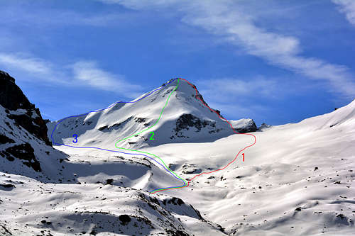
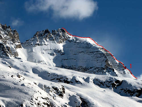
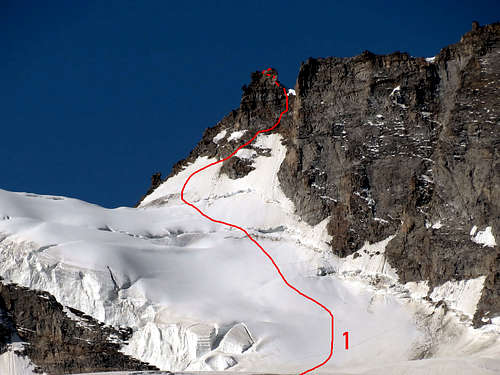
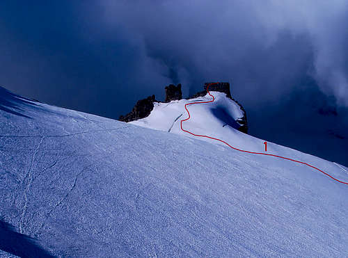
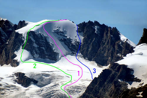
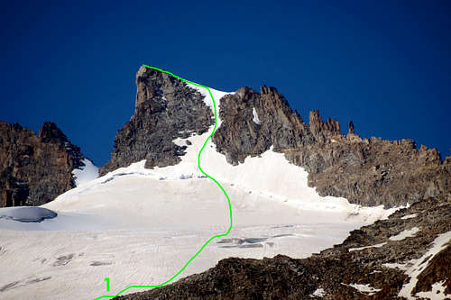
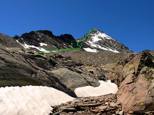
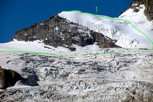
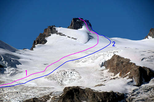
 1) - NE Arête (Normal route): W. A. B. Coolidge and mountain guides Christian Junior Almer, (Aug 14th, 1888). Difficulty AD-.
2) - N Wall (Bozzetti route): Angelo Bozzetti, solo, (Aug 08th, 1962). Difficulty IV° V° D+.
3) - N Wall (Left route): Engineer Guarducci of the I. G. M., probably, (Jul 1890). Certainly E. Allegra, U. Sandrinelli and P. Dayné, (Jun 24th, 1902). Difficulty D-.
4) - N Wall (Central direct route): Osvaldo Cardellina, Giuseppe Lamazzi, Camillo Roberto Ferronato and "Gigi" Gadin, (Jul 11th, 1979). Difficulty D-.
5) - SW Wall (Little gully): Ilario Antonio Garzotto and Osvaldo Cardellina, (Jul 16th, 1967), in descent. Difficulty PD+/AD-/F+.
|
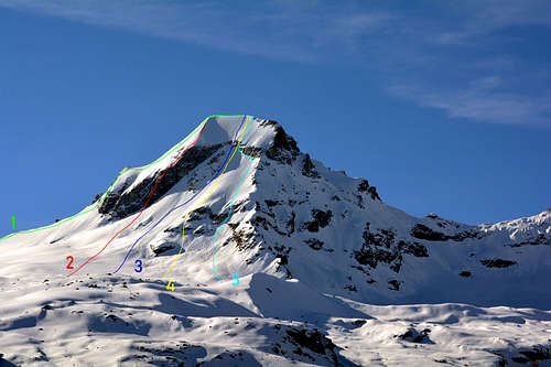
 1) - N-E Ridge: G. Frasca and G. Blanchetti, (Jul 14th, 1881) - (first known ascent). Difficulty F+/PD-.
2) - N Wall: E. Barisone, S. Gallo and M. Strumia, (May 02th, 1920). Difficulty III/AD.
3) - N-NW Edge: G. Yeld, F. and S. Pession, (Aug 10th, 1897). Difficulty PD/PD+.
4) - W Wall: E. Martino and Remo Chabod (Aug 31th, 1936). Difficulty AD+/D+.
5) - Monciair Collar: E. Canzio, N. Vigna, A. Boggiato and M. Ricchiardi, (Aug 02th,1890). Difficulty F+/PD-.
6) - SS-W Ridge: Maria Sbrojavacca and A. Bonacossa, (Jul 11th, 1921). Difficulty PD+/AD-.
|
Essential Gear
Complete alpine equipment.
Attrezzatura alpinistica completa.
Refuges and Bivouacs
Rifugio VITTORIO EMANUELE II (2.735m) Valsavarenche
Rifugio FEDERICO CHABOD (2.750m) Valsavarenche
Rifugio CITTA' DI CHIVASSO (2.603m) Valsavarenche
Rifugio SAVOIA (2.534m) Valsavarenche
Rifugio VITTORIO SELLA (2.588m) Valle di Cogne Valnoney
Bivacco SEBASTIANO e RENZO SBERNA (3.414m) Colle est del Gran Neyron Valsavarenche
Bivacco Carlo Pol (3.183m) Ghiacciaio della Tribolazione Valle di Cogne Valnontey
Bivacco MARCELLO GERARD e ETTORE GRAPPEIN (3.200m) Ghiacciaio della Tribolazione Valle di Cogne Valnontey
Bivacco LIONELLO e LUCIO LEONESSA (2.910m) Cresta est dell'Herbetet Valle di Cogne Valnontey
Books and Maps
BOOKS:
- "Guida dei Monti d'Italia-Gran Paradiso Parco Nazionale" E. Andreis, R. Chabod, M. C. Santis, Club Alpino Italiano/Touring Club Italiano, prima Ed. 1939; seconda Ed. 1963; terza Ed. 1980.
- "Guida delle Alpi Occidentali", di Giovanni Bobba e Luigi Vaccarone C.A.I. Sezione di Torino Volume II (parte II), 25 Maggio 1896.
- "Il Parco Nazionale del Gran Paradiso" di G. Berruto, volume 2° Ed. I.G.C. Torino 1981, 2000.
- "80 itinerari di Escursionismo Alpinismo e Sci Alpinismo in Valle d'Aosta", di Osvaldo Cardellina, Ed. Musumeci, Giugno 1977 (in Italian); seconda Ed. Luglio 1981; terza Ed. Luglio 1984; (in French), prima Ed. Febbraio 1978; seconda Ed. Marzo 1980.
- "Gran Paradiso" A. Gegenfurtner, G. Klotz, F. Müller, Ed. Bergverlag Rudolf Rother, Monaco 1980 (in tedesco).
- "Gran Paradiso" G. Klotz Ed. Bergverlag GmbH Rother, Monaco 2005 (in tedesco).
- "Rifugi e bivacchi in Valle d'Aosta", di Cosimo Zappelli aggiornata da Pietro Giglio, Musumeci Editore, Luglio 2002.
- "Diari Alpinistici" di Osvaldo Cardellina e Indice Generale accompagnato da Schedario Relazioni Ascensioni 1964-2019 (inediti).
 |
 |
 |
 |
 |
MAPS:
- Kompass "Gran Paradiso Valle d'Aosta" Sentieri e rifugi-Carta turistica 1:50.000.
- I.G.C. Istituto Geografico Centrale "Gran Paradiso La Grivola Cogne" Carta 1:25.000.
- I.G.C. Istituto Geografico Centrale "Il Parco Nazionale del Gran Paradiso" 1:50.000.
- I.G.M. Istituto Geografico Militare Foglio 41 "Gran Paradiso-Cogne" 1:25.000.
- AIAT Cogne "Gran Paradiso" Cogne Aymavilles-Walking map 1:25.000.
- Enrico Editore Ivrea "Gruppo del Gran Paradiso" 1:50.000.
- Studio F.M.B. Bologna "Gran Paradiso" 1:50.000.
- L'Escursionista "Valle di Cogne Carta dei Sentieri" (n° 10) 1:25.000.
- L'Escursionista "Tour de la Vallée de Cogne Grand Paradis" Carta dei sentieri 1:25.000.