
-
 111524 Hits
-
 99.48% Score
-
 114 Votes
|
|
Mountain/Rock |
|---|---|
|
|
40.45956°N / 112.62628°W |
|
|
Tooele |
|
|
Hiking, Mountaineering |
|
|
Spring, Summer, Fall, Winter |
|
|
11031 ft / 3362 m |
|
|
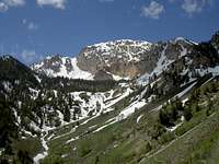
Overview
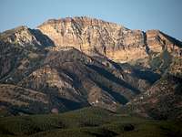
Deseret Peak
Deseret Peak is the highest summit in the Stansbury Mountains. It is an impressive and prominent mountain. This mountain is one of the few in the West Desert with a nice system of hiking trails. It is clearly visible for many miles around, particularly from across the Great Salt Lake to the north and the desert valleys to the west. It has large cliffs that drop precipitously down toward South Willow Canyon. While the Wasatch Range may be crowded with hikers on the weekends, you can expect more solitude here.
This area has rugged terrain and high peaks. North Willow Peak and South Willow Peak are located on the ridge to the north of Deseret Peak. Much of the higher elevation is alpine with open basins and exposed rocky ridges. Vegetation includes dense mountain brush mixed with sagebrush and grass, various firs, juniper, and aspen.
The Deseret Peak Wilderness is located in western Utah, near the cities of Tooele and Grantsville. The Wilderness was established by Congress in 1984 with passage of the Utah Wilderness Act. It is entirely located within the Stansbury Range on the Wasatch-Cache National Forest. The Deseret Peak Wilderness consists of approximately 25,500 acres and is generally bounded on the north by the Pass Canyon drainage, on the south by Vickory Mountain, on the west by Skull Valley and on the east by the Mack Canyon-Big Hollow Trail. The highpoint of the Northern Stansbury Mountains is Onaqui BM. This shouldn't be confused with the Onaqui Mountains which form the southern section of the Stansbury Mountains. The highpoint in that area is Stookey Peak.
Deseret Peak is the highpoint of Tooele County. It is hiked often each year by people wanting to complete all of the county highpoints in Utah. The name of the county is often mispronounced. The most common pronunciation is either Two-ella or Tu-will-uh. It certainly doesn't sound the way it is spelled. Another interesting fact is that Deseret Peak is one of the 57 mountains in the lower 48 states that have over 5,000 feet of prominence. These peaks are often called an "Ultra" by those pursuing such lists. Deseret Peak has over 5,800 feet of prominence making it the 4th most prominent peak in Utah.
Getting There

Deseret Peak

Deseret Peak
From Salt Lake City, drive to Interstate-80 West. Follow I-80 and then take (exit 99) named for Tooele/Stansbury. Now drive south on Highway 36/SR 138. Drive 3.5 miles and turn right on State Road 138. Follow this road for 11 miles to the city of Grantsville. Turn left on West Street at the end of town. This road will become Mormon Trail Road. Drive 5 miles south from Grantsville to a sign for South Willow Canyon. Turn right and follow this road which becomes gravel near the national forest boundary. Go to the end of the road at the Loop Campground and trailhead.
Moogie737 says that: 9-8-17 As of today the large sign on the road leading out of Grantsville was MIA. The sign pointing to North Willow Canyon was there but the bigger sign pointing to South Willow Canyon and the Loop Campground was nowhere to be seen. As of today all one has is a small green "street" sign saying South Willow Canyon road. Perhaps UDOT will remedy this, but be aware just in case.
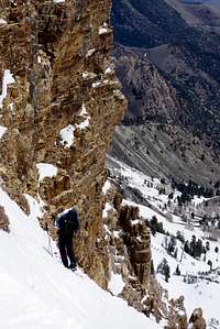
Route Information
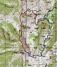
There are two main routes that people use to reach the summit. The standard route is up South Willow Creek. A lot of hikers return down the same way. The best way to experience the whole mountain is to do a loop hike and descend down the Pockets Fork-Dry Lake Fork trail. This option is only slightly longer in distance. There are also other routes including the Twin Couloirs.
 Deseret Trail |
 The Saddle |
 Mill Fork View |
South Willow Creek - (Class 1)
The trail climbs through an aspen forest for about three-fourths of a mile before crossing a stream. Then it, shortly thereafter, reaches a fork. The right fork leads to Willow Lakes. The left fork heads south towards the peak. This is the route you will want to take. In the next mile and a half, the trail climbs up Mill Fork for almost 2,000 feet, crossing several meadows with the southwest face of Deseret Peak appearing above. You'll reach a saddle at the head of the canyon. The trail goes up switchbacks on the final ascent to the ridge and then to the summit. There are spectacular views of the surrounding salt flats, nearby mountains, and Wasatch Mountains. You can take the same route back down or descend the Pockets Fork trail. To complete the loop, hike north of Deseret Peak for about two miles to where the trail forks. Take the south fork back instead of the one to Willow Lake. The route is 8 miles round trip with 3,600 feet elevation gain.
 Deseret View |
 North Ridge |
 North Ridge |
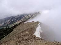
Pockets Fork - Dry Lake Fork - (Class 1)
This is often used as a descent route for Deseret Peak and can also be used as an ascent route. It goes along the north ridge of the peak and then heads east. It is an easy hike for a mile or so and then begins a steep descent down a glacial headwall. The route continues north along the ridge for two miles. You will pass two saddles that give you excellent views into Dry Lake Basin. It is tempting to use some of these saddles to descend gullies into the basin but they are steep and full of loose talus. Pockets Peak, 10,129 feet, is a nice bonus peak that you can add to your hike which is located south of Pockets Fork Saddle. The trail will start heading east, crosses a pass, and then descends for 0.5 mile when you will reach another trail junction. Turn right and this route will take you back to the trailhead. The loop up South Willow Creek and down the Pockets Fork trail is about 8.4 miles round trip.
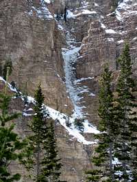
 Twin Couloirs |
 Twin Couloirs |
 Twin Couloirs |
Twin Couloirs - (Snow Route / Ski Class 3)
The Twin Couloirs are for people looking for a something more challenging and different than the standard routes up Deseret Peak. The couloirs are located southeast of the summit of Deseret Peak. They face toward the north and are easily identified. A long rock rib separates the two couloirs which are not far from each other. They are referred to as West Twin Couloir and East Twin Couloir and may contain snow from winter through early summer. These couloirs offer over 1,000 feet of climbing and they are often skied. After the snow melts the couloirs hold steep talus and scree. A route page was added by Ed F.
 South & North Willow |
 South Willow Peak |
 North Willow View |
South & North Willow Peaks - 10,685 feet - (Class 2)
Some of you may be interested in hiking to two unofficially named peaks located on the ridge north of Deseret Peak. They are commonly referred to as North Willow Peak and South Willow Peak. North Willow is Peak 10,521 and South Willow is Peak 10,685. These two peaks may also be referred to as North Medina Peak and South Medina Peak, a name that was mentioned by the Wasatch Mountain Club. You can combine them with a day hike of Deseret Peak from the Pockets Fork route.
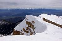
Red Tape

Deseret Peak
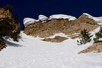
Cornices
Deseret Peak is located in Wasatch-Cache National Forest
There are no fees for climbing Deseret Peak.
All Wilderness Area rules should be observed. There is a fee for staying overnight at the established campgrounds.
This area has been successfully restored to pristine wilderness from former mining days, so it isn't a good idea to cut switchbacks or engage in any other activity that would encourage erosion. There are plenty of mule deer and other wildlife in the area so try to exercise caution during hunting season in autumn.
Weather
Stansbury Mountains

Weather on the Ridge
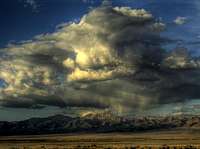
The summer months are the normal time to visit these mountains. Even though it is located in a desert region, this is a high elevation mountain range. In summer temperatures can range from near 80 degrees in the daytime to below 40 degrees at night. Occasional summer thundershowers can be expected. In winter, temperatures will be around 30-40 degrees but may be much colder in the mountains. Be prepared for changing weather conditions in the higher elevations.
Here is the weather forecast for the city of Tooele and the NWS
This is a forecast for the city of Grantsville
When To Climb
Deseret Ice
Ready to Ski
Deseret Peak is usually hiked between Memorial Day and late October. Typical summer months apply but experienced climbers can climb year round. Vehicle access on the gravel road is closed during the winter months, but the area could be accessed on skis or snowshoes, adding mileage to the approach.
The road is plowed up until the end of the paved road near the forest boundary. This is where you will have to park during winter. The road to the Loop Campground is popular with snowmobiles and skiers and is packed down pretty well. Some people may not need skis or snowshoes until reaching the normal trailhead but it depends on current conditions.
During light snow years it is possible to start near the normal trailhead. The winter route generally follows the same route up South Willow Creek as in summer. This drainage is steep in many parts. It becomes easier walking along the ridgeline and the snow should be hard-crusted toward the summit. Be careful during high avalanche conditions especially when climbing any of the couloir routes.
Thanks to SP member Moogie737 for the following info: There is a steel gate which is usually closed on November 1st, meaning that one must hike or run or ATV or snowmobile the last 4 miles leading to the Loop CG. I am not sure when it opens in the spring.
Camping
Deseret Summit
Deseret Peak
This area has many campgrounds. There are six campgrounds in South Willow Canyon. They have picnic tables, fire pits, and restrooms. They are usually open between late-May and mid-October. All of them are on a first come, first serve basis, except for Upper Narrows Campground where you can reserve a large group campsite.
Camping is also available at the trailhead near the Loop Campground. Individual sites cost about $14.00 a night.
Information on campgrounds can be found at this website
Backcountry Camping Regulations:
Group size limit of 10 or less people, No mechanized vehicle use, including mountain bikes, are allowed on trails, camp at least 200 feet away from any road, hiking trail, or lake, and practice leave no trace techniques.
South Willow Creek Camgpgrounds:
1) Cottonwood Canyon Campground – Located 1 mile from the forest boundary. 2 campsites at an elevation of 6,080 feet.
2) Intake Campground – Located 1.5 miles from the forest boundary. 4 campsites at an elevation of 6,320 feet.
3) Boy Scout Campground – Located 1.7 miles from the forest boundary. 5 campsites. It sits at 6,320 feet elevation.
4) Lower Narrows Campground – Located 2.2 miles from the forest boundary. 5 sites at 6,840 feet elevation.
5) Upper Narrows Campground - Located 3 miles from the forest boundary. 8 campsites at 6,920 feet elevation.
6) Loop Campground – The trailhead to Deseret Peak begins here. 9 campsites located 4.5 miles from the forest boundary.
History
Deseret Peak Map
The State of Deseret: The word Deseret is often used to mean the state of Utah. When the Mormons first came to this new territory, they named the area The State of Deseret, which is a reference to the honey bee in The Book of Mormon. The Mormons regard the honey bee as a symbol of industriousness. The beehive was adopted, in 1847, as an official emblem and represents the qualities of industry, perseverance, thrift, stability, and self-reliance, all virtues respected by the region's early settlers. The beehive can be seen as the centerpiece of the Utah Great Seal and the Utah State Flag.
The Stansbury Range was named after Captain Howard Stansbury. He was an early surveyor to the area. Stansbury Island, at the southern end of the Great Salt Lake, was also named after him. The island has a dirt road connecting it to the mainland. He was sent to survey the Great Salt Lake area in 1850. Tooele is the county's largest city, and took its name from the valley, which Captain Howard Stansbury spelled "tuilla" on his surveying maps in 1849-50.
Onaqui vs. Deseret: Thanks to Dmitry for this information -- On the early maps, this range was named Onaqui Mountain. The first transcontinental survey placed a survey mark designated Onaqui on a prominent high point in this ridge, about 10 miles North of here, in 1887. Five years later they decided to place an additional benchmark at the highest point of the range, and named this second survey mark "Deseret". As it often happens, benchmark designation on the topo was co-opted as the name of the peak.
The name "Onaqui" is still used both for the Northern prominence of the Stansburies and for the Southern part of the range.
Speed Ascent
From SP member scout: On Saturday, October 22, 2016, I ran Deseret Peak again with the purpose of establishing a record. My ascent time was 1:02:13 and my total time by the time I got to the bottom was 1:34:10. The rumored record for the ASCENT ONLY is 55 minutes. As far as I know, there is no record established for a combined ascent/descent time. I think that having an unofficial/official record for Deseret Peak would be interesting and beneficial for the community surrounding the mountains. Deseret Peak is a beautiful climb with stunning views and should get more attention from the hiking/mountain running community.
Books
1) Utah Mountaineering Guide
By Michael R. Kelsey. This book has info for many mountain ranges in Utah including the Stansbury Mountains.
2) High In Utah (County Highpoints)
By Michael Weibel. This book has information on climbing all of Utah's county highpoints.