
-
 41811 Hits
-
 96.21% Score
-
 58 Votes
|
|
Area/Range |
|---|---|
|
|
39.95370°N / 105.2992°W |
|
|
Hiking, Mountaineering, Trad Climbing, Sport Climbing, Toprope, Bouldering, Ice Climbing, Mixed, Scrambling, Skiing |
|
|
Spring, Summer, Fall, Winter |
|
|
8549 ft / 2606 m |
|
|
Overview
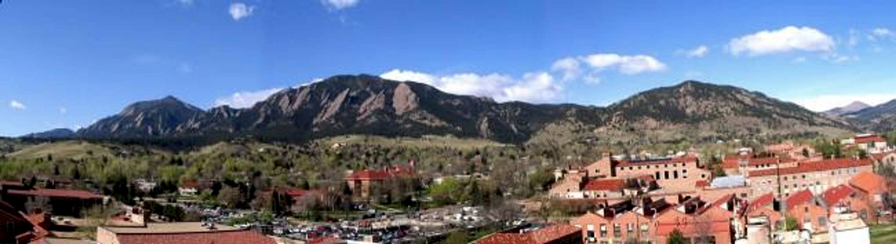
Bear Peak, Green Mountain & Flagstaff Mountain, from left to right from the University of Colorado-Boulder. Photo: CharlesD
The Boulder Range is composed of four major summits and 81 minor summits, all within the confines of Boulder and Eldorado Springs, Colorado. While technically members of the Front Range, these peaks separate the high plains to the east from the jumbled canyons and hills rising up to the Indian Peaks Wilderness on the Continental Divide. In the space of three miles, the terrain rises from the flat prairie at 5500' to summits at over 8000'. Few other places in the world is the transition from plains to mountains as abrupt and obvious. This is largely due to a great, tilted block of Fountain and Eldorado Formation sandstone which forms the peaks and the world-famous Flatirons formations which cover the eastern side of the range. The northern and southern boundaries of the range are somewhat nebulous. For the purpose of this range, I have used Mount Sanitas as the northern boundary and Eldorado Mountain as the southern boundary. Nearly every peak listed below lies within Boulder's Open Space and Mountain Parks or Eldorado Canyon State Park.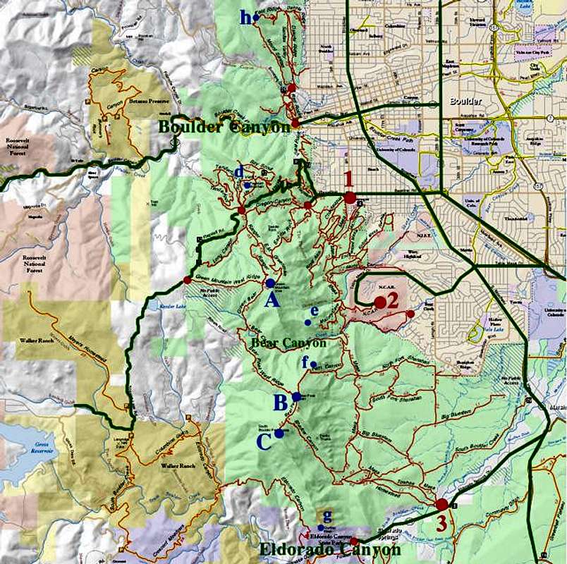
Map of the Boulder Range. Blue circles denote peaks, red circles denote trailheads. Major roads are in green and established trails are in red. See this link for more detailed maps. Map submitted by CharlesD
Major Summits
All of these summits have at least 300' of optimistic prominence & are listed from north to south:
- Green Mountain (A, 8144', Class 2+) is the northernmost of the four major peaks. It is also the gentlest and easiest of the three to climb. There are spectacular views to the east and west.
- Bear Peak (B, 8461', Class 3) is a surprisingly tough hike up steep, rocky trails to a narrow, rocky ridge of a summit. The hike is harder than it looks and the views in all directions are staggering.
- South Boulder Peak (C, 8549', Class 2+) is the monarch of the range and hidden behind Bear Peak from most angles to the east. It is more remote than Bear or Green and sees comparitively fewer hikers, however it is an easy 0.6 miles from the summit of Bear and makes a good combination.
- Eldorado Mountain (not shown on map above, 8335', Class 4) lies to the south of Eldorado Canyon. It is the first of a series of little-known summits south of Boulder but is geologically linked to the Boulder Range. There are no established trails up Eldorado and it represents one of the more adventurous climbs in the area. Private property is an issue as well.
![]()
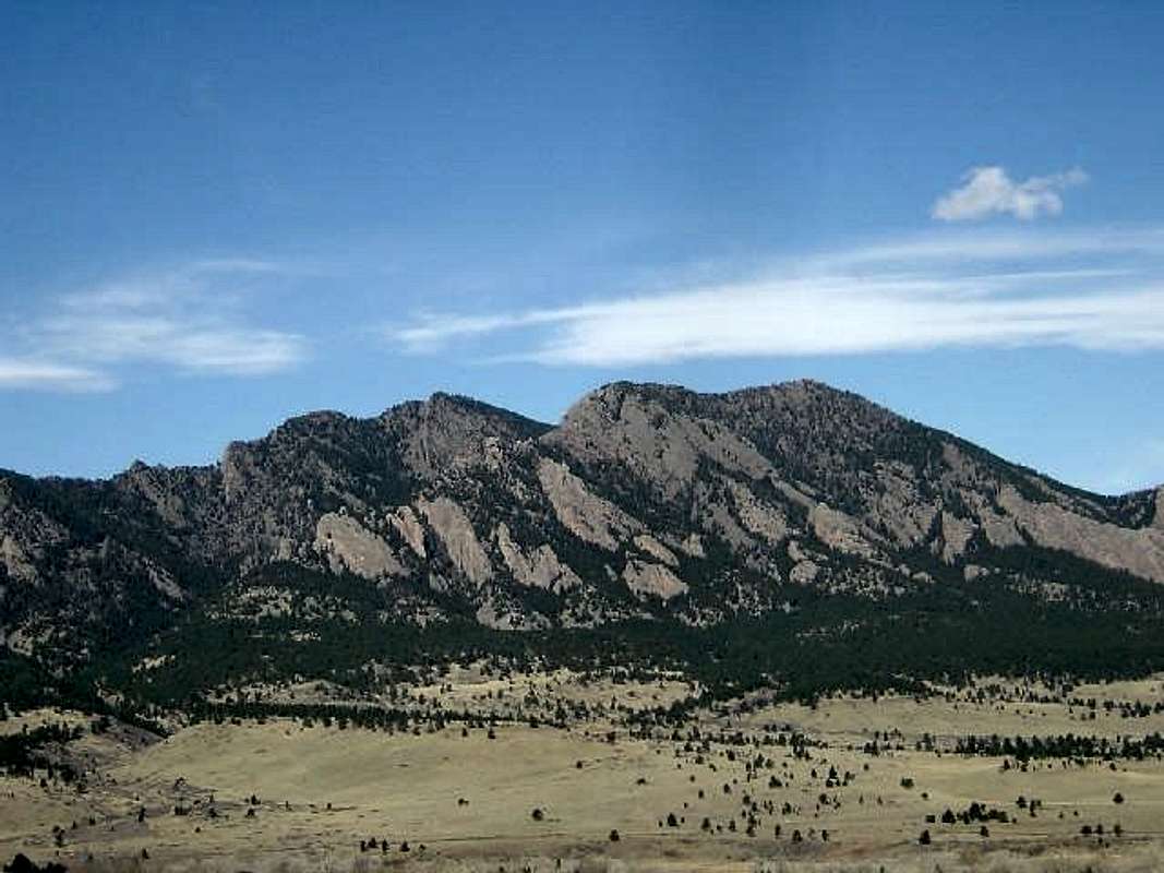
South Boulder Peak & Bear Peak, from left to right. Photo: ChrisMinor Summits
All of these summits have less than 300' of optimistic prominence & are listed from north to south: - Mount Sanitas (h, 6863', Class 2)
- "Sanitas Mountaineer Top" (6820', Class 1)
- "Dakota Ridge" (6020', Class 2)
- "Anemone Mountaineer" (6380', Class 2)
- Red Rocks (5820', Class 3)
- "Rock Island II" (5700', Class 3)
- "Rock Island I" (5660', Class 5.0)
- "4th Elephant Buttress" (5700', Class 2+)
- Flagstaff Mountain (d, 6980', Class 2+) northern shoulder between Green Mountain & Boulder Canyon. A paved road accesses the summit. Flagstaff is known for its bouldering.
- "Crown Rock" (6380', Cl;ass 5.0)
- "Alamo Rock" (6380', Class 5.3)
- "First Pinnacle" (6220', Class 5.0)
- "Second Pinnacle" (6220', Class 5.0)
- "Gregory Flatironette" (6420', Class 4)
- Saddle Rock (7020', Class 2+)
- "The Spy" (6780', Class 5.3)
- "First Flatiron" (7300', Class 5.2)
- "Sunset Flatironette" (7260', Class 4)
- "Second Flatiron" (7140', Class 5.0)
- "Third Flatironette" (6620', Class 4)
- "Third Flatiron" (7220', Class 5.2)
- "Green Thumb" (7300', Class 5.4)
- "Terror Summit" (7420', Class 5.2)
- "Queen Anne's Head" (6820', Class 5.4)
- "The Hammerhead" (6980', Class 5.0)
- "Willy B" (7460', Class 5.7)
- "East Green Mountain" (7980', Class 2+)
- "Green Mountain Pinnacle" (7460', Class 5.2)
- "The Regency" (6860', Class 3)
- "Royal Arch" (6980', Class 4)
- "Fifth Flatiron" (7500', Class 5.0)
- "Schmoe's Nose" (7660', Class 5.6)
- "The Fist" (7620', Class 5.5)
- "Angelic Perch" (7380', C;ass 5.3)
- "Hillbilly Rock" (7020', Class 5.2)
- "Heaven" (7060', Class 5.3)
- "Satan's Slab" (7300', Class 5.0)
- "Lower Angel's Way" (7300', Class 5.4)
- "Portico" (6620', Class 2)
- Table Mountain (6220', Class 2+)
- "Achean Pronouncement" (6900', Class 5.7+)
- "Front Porch" (6820', Class 5.0)
- "Lost Porch" (6860', Class 4)
- "Backporch" (7180', Class 5.6)
- "Gazebo East" (6580', Class 2)
- "The Dreadnaught" (7260', Class 5.2)
- "South Green Mountain" (8073', Class 5.2)
- Dinosaur Mountain (e, 7380', Class 2+) a little-known, sub-summit southeast of Green Mountain directly west of NCAR. The summit is a wonderful 3rd-class scramble amongst little-known, wild Flatirons with fantastic views.
- "Red Devil" (6980', Class 3)
- "The Box" (7180', Class 4)
- "Yuri Point" (5980', Class 1)
- "Finger Flatiron" (7140', Class 5.4)
- "Fo" (7300', Class 5.2)
- "Der Zerkle" (6820', Class 5.0)
- "Dinosuar Rock" (6740', Class 5.0)
- "Der Freischutz" (6940', Class 5.0)
- "Southern Dinosaur Egg" (6540', Class 5.6)
- "Overhang Rock" (6820', Class 5.6)
- "Harmon's Flatironette" (6940', Class 4)
- "Seal Rock" (7260', Class 5.4)
- "Fiddlehead" (7580', Class 5.4)
- "Goose Rock" (7380', Class 3+)
- "The Nebel Horn" (f, 7580', Class 3) a northern shoulder of Bear Peak. Together with Dinosaur Mountain, these form the guardians of Bear Canyon and are covered with flatirons. The summit is a hard-to-find 3rd class scramble.
- "The Sphinx" (7380', Class 5.7)
- "Tiny Tower" (7140', Class 5.2)
- "The Apostle" (6940', Class 3)
- "Devil's Horns" (7900', Class 5.2)
- "Devils Thumb" (7820', Class 5.7)
- "Icarus-North" (7180', Class 5.x)
- "The Pyramid" (7700', Class 5.4)
- "The Fatiron-East" (7260', Class 5.4)
- "The Maiden" (7340', Class 5.6)
- "Jamcrack Spire" (7300', Class x)
- "Tower of the Moon" (7180', Class 5.x)
- "The Matron" (7220', Class 5.5)
- "Dakota Hogbacks" (6620', Class 1+)
- Shirttail Peak (g, 7340', Class 3)
- "Rebuffat Summit" (6820', Class 5.7)
- "Wind Tower" (6220', Class 5.4)
- "T1" (6820', Class 5.4)
- "The Bastille" (6180', Class 5.2)
- "Goshawk Ridge" (6636', Class 1)
- "Micky Mouse" (7780', Class 5.4)
Climbing
The Boulder Range not only provides great hiking opportunities, but are also home to spectacular, world-class rock climbing. There are three principle venues for climbing in the Boulder Range, each of them remarkably different in style and geology.
The Flatirons
From almost any point in Boulder, it's hard to miss the Flatirons, huge plates of red-grey sandstone tilted at a about 50o along the eastern side of Eldorado Mountain, South Boulder Peak, Bear Peak and Green Mountain. The east faces of the Flatirons are typically quite easy, runout climbing; 3rd class to 5.7+ or so. Harder routes, up to 5.13c, tend to be found on the north, south and west faces. Those looking for long, casual routes could do worse than the east face routes on many Flatirons. The largest and most popular rocks are found on the northern end of the range as the First and Third Flatirons. The standard east face route on the Third Flatiron (5.4) has been described as "eight pitches of the best beginner climbing in the Solar System." Similarly, high quality, classic routes exist on many less popular rocks such as Seal Rock, the Matron, and the many clustered Flatirons on Dinosaur Mountain. Gerry Roach, guidebook author and Boulder mountaineer extraordinaire, has put forward a list of classic Flatirons climbs. Ten of these routes have been declared to be the ultraclassic list (all are 5.7 or easier) and a tradition of racing through the climbs has been established. Linking these top 10 routes requires over 50 pitches of climbing, 13 rappels, over 12 miles of hiking and over 8000 vertical feet of elevation gain. The record trailhead-to-trailhead stands at under 7 hours.
The Flatirons not only provide hundreds of rock climbing routes, but also provide some ice climbing options as well.
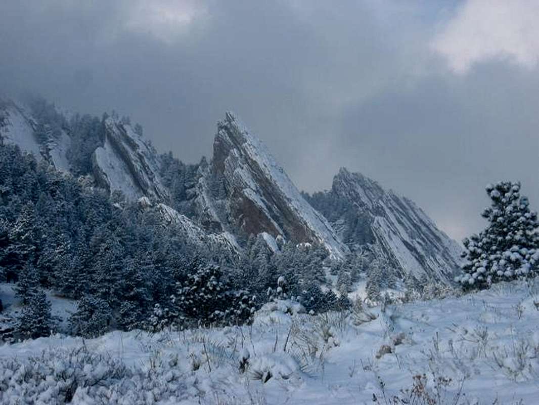
Snowy Flatirons. Photo: Diggler
Eldorado Canyon
"Eldo" as it is known is a deep slash through the Fountain and Eldorado Formation sandstone that forms much of the range. Eldo is an intimidating and storied place where trad climbing pioneer hardmen such as Layton Kor, developed cutting-edge routes and new techniques starting in the 1950s. Innovation and popularity continue to this day; expect crowds on the classic routes. Complete details of the hundreds of climbs at Eldo can be found in the Falcon Guide "Rock Climbing Eldorado Canyon". A few of the more moderate ultraclassic climbs at Eldo include: Bastille Crack (5.7), Yellow Spur (5.9+), Wind Ridge (5.8), Great Zot (5.8+), Rewritten (5.7), and Swanson Arete (5.5).
Boulder Canyon
Boulder Canyon is not as famous or spectacular as the other two Boulder venues. A dozen or more crags of various sizes line the sides of the canyon along the Boulder Creek at the north end of the Boulder Range. The canyon tends to be fairly top-heavy with many short, hard routes in the 5.10-plus range, but there are a number of good moderate climbs as well. Unlike the Flatirons or Eldo, Boulder Canyon is predominantly hard granite and the climbs have a very different feel to them. Boulder Canyon also provides a number of ice climbing routes.
Flagstaff Mountain
Flagstaff is known for it's bouldering. The same gritty sandstone which forms the Flatirons to the south crops up in numerous small crags perfect for bouldering problems. Particularly famous are the Monkey Traverse and Beer Barrel Rock.
Skiing
Yes, the Boulder Range does provide rare skiing opportunities after big storms. Chautauqua Mesa was once a ski area that was open intermittently from 1949-1963 and had one rope tow. The Ski Jump Trail is now an established hiking trail. In addition, the 1911 Gully on the Third Flatiron was skied by Boulder residents Bill Wright and Stefan Griebel.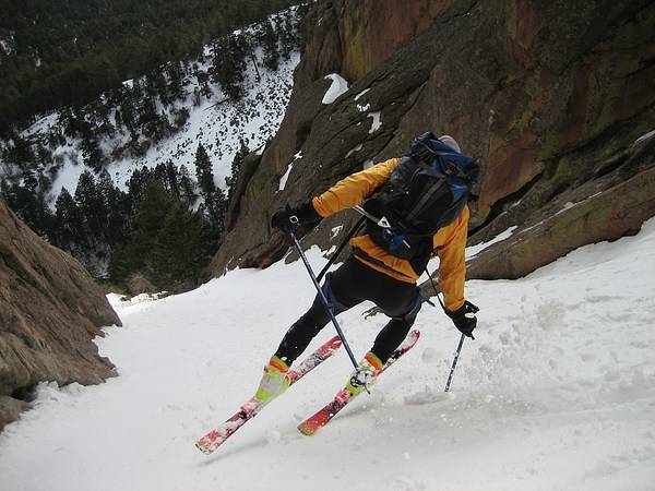
Bill Wright skiing 1911 Gully on the Third Flatiron. Photo: Stefan Griebel
The Trailheads and Trails
The Boulder Range is serviced by a large network of trails and are quite popular. There are three major trailheads and numerous minor ones as well. The three major trailheads are listed as they are located from north to south and the numbers correspond to the map above.| 1 | Chautauqua is located at the west end of Baseline Road. From the intersection of Broadway and Baseline, head west up the hill approximately one mile. Turn left (south) at Chautauqua Park. There is limited parking immediately on the right. When this lot is full, you can continue up the road to the Gregory Canyon parking area (fee area for non-Boulder county residents). Chautauqua accesses the northern Flatirons, Green Mountain and the Mesa Trail. |
| 2 | NCAR (National Center for Atmospheric Research) has a large parking area (hundreds of cars) and is the best access for Bear Canyon and the middle part of the Mesa Trail. It provides access to Dinosaur Mountain and the northern routes on Bear Peak and South Boulder Peak as well as the central Flatirons. Head west 2.5 miles on Table Mesa Drive from the intersection with Broadway. Watch for deer and cyclists in the road. |
| 3 | South Mesa Trailhead is located on Eldorado Springs Road and can accommodate several dozen cars (fee area for everyone). This is the place to access the southern end of the Mesa trail, Shadow Canyon, and the southern Flatirons. Head west from the intersection of Marshall Road with Broadway/Rt 93. |
Red Tape
Flood closures in the Boulder's Open Space & Mountain Parks are still in effect. Click here for details.Most land within the Boulder Range is managed by either Boulder's Open Space & Mountain Parks, Eldorado Canyon State Park or the Bureau of Land Management. See map above. Green represents land within Boulder's Open Space & Mountain Parks, blue represents land with Eldorado Canyon State Park & yellow represents land managed by the Bureau of Land Management.
Since the majority of the Boulder Range is managed by Boulder's Open Space & Mountain Parks, see below for the most important red tape in Boulder's Open Space & Mountain Parks:
- There are periodic Wildlife Closures of parts of the Open Space to protect nesting raptors. Typical closure times are February 1 through July 31st, but check the link for exact details. Most hiking trails remain open, but climbing is not allowed on most of the Flatirons during this time. The exception are the 1st and 2nd Flatirons which remain open year-round.
- No camping in the Open Space is allowed.
- Mountain Bikes are not allowed on most of the trails including all summit routes.
- Dogs must be leashed or under voice control at all times.
- Dogs are no longer allowed on the Greenman Trail leading to Green Mountain's Summit.
- A $3 parking fee is charged for non-residents of Boulder County at trailheads along Flagstaff Road. This includes Gregory Canyon but not Chautauqua.
- A $5 parking fee is charged for everyone at the South Mesa Trailhead and South Boulder Creek-West Trailhead.
When To Climb
The Boulder Range offers great hiking year round. The peaks may get icy during the winter and packed trails often don't melt out until the rest of the snowpack is long gone. It is not uncommon to see ice and snow on the summits into June. Yak Trax or MICROspikes will be beneficial when there is a significant amount of ice on the trails. Be aware of wildlife closures (see Red Tape) if you want to rock climb.
Camping
No camping is allowed in Boulder's Open Space & Mountain Parks or Eldorado Canyon State Park. However, free camping can be found in Roosevelt National Forest up Boulder Canyon.
External Links