
|
|
Mountain/Rock |
|---|---|
|
|
39.06080°N / 107.9437°W |
|
|
11189 ft / 3410 m |
|
|
Overview
This peak is the second highest point in Mesa County, and is located on the Grand Mesa (usually known locally as simply "The Mesa"). It is also the most scenic and popular peak on the Grand Mesa. Despite its low elevation, Crag Crest has some of the best views in the state.
The Grand Mesa is a large scenic region and has 300 lakes scattered throughout the mesa top. In summer, the cool Mesa is a welcome relief from the hot and barren deserts below and surrounding the Mesa. The only drawback is the millions of mosquitoes present in June and July, and often into August as well.
In winter the Mesa is a crosscountry skiing and snowshoeing paradise. The Mesa is often quoted as the World's largest flat-topped mountain, but I believe the Tepuis in Venezuela/Brazil/Guyana are larger.
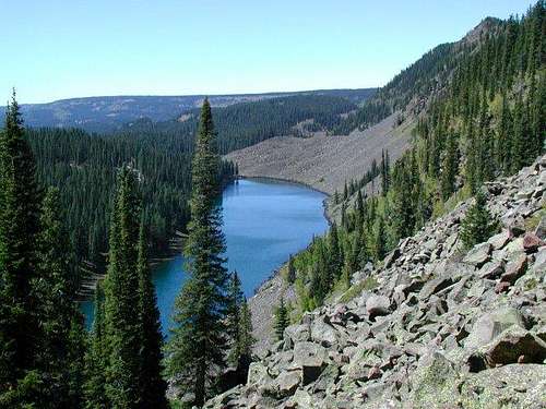 Looking down to the south over one of the many lakes below the Crag Crest Trail.
Getting There
There are two possible trailheads for this hike.
Island Lake:
Take the Highway 65 exit off I-70 17 miles east of Grand Junction. Drive south on Highway 65 to Island Lake, which is 8 miles beyond Mesa Lakes Resort. Watch for the sign on the left of the highway just past the Grand Mesa Lodge. Park at the trailhead.
Eggleston Lake:
Continue past Island Lake and turn left on FR 121. Drive this paved road 2.5 miles to a junction. Turn left and drive another .9 miles to the parking lot and trailhead.
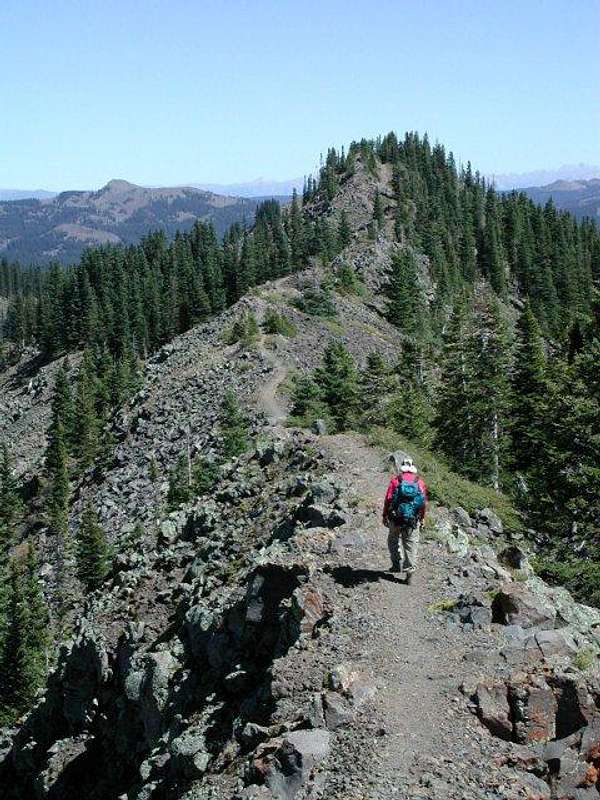 Heading toward the Crag Crest on a gorgeous ridge walk with views in all directions.
Routes Overview
This recommended route is the Crag Crest Loop Hike. You can start at either trailhead. The Island Lake route is slightly longer (1 mile), but it is a shorter drive. It is recommended you hike in a direction that takes you over the top first, in order to avoid the afternoon thunderstorms. There is nowhere to get off the knife-edge in a thunderstorm, so beware, and do this section early!
Briefly put (see the route page for much more detail) the route follows the trail from either trailhead up to the ridge crest and follows it for quite a while. The ridge becomes a knife-edge with steep cliffs on either side of the trail and this is the most spectacular section. The views are incredible, and are some of the best in Colorado. You will see many lakes down on the Mesa, as well as the Elk Mountains, San Juans, and the La Sal Mountains of Utah, the Book Cliffs, and surrounding valleys.
One reason Crag Crest provides some of the best views in Colorado is that you are on the ridge for so long (but without much altitude gain). Since the "summit" is so long you get 360-degree views all along the ridge rather than just at one point as is with most peaks. This ridge is a real challenge for winter climbers. Stay off the ridge when there is a chance of thunderstorms! After crossing the ridge, the lower loop is followed back to either trailhead.
Other possible routes include following either trail to the highest summit and returning the same way.
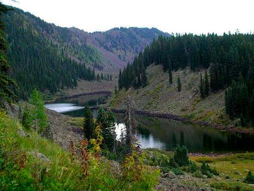 Looking down over Long Lake, along the Crag Crest Trail.
Red Tape
No permits are required.
When To Climb
Late June through mid October is the snow-free hiking season. June, July, and August have many mosquitoes. September and October are usually pleasant and without mosquitoes.
The peak is a great challenging trip in the winter. The trip is no more than a hike in the summer, but in winter the knife-edge ridge is a challenge.
Camping
There are many campgrounds and campsites on Grand Mesa. There are many good campsites on the lower part of the loop trail.
Mountain Conditions
Call the Grand Mesa National Forest, Grand Mesa District, at 970-242-8211.
GRAND MESA WEATHER FORECAST
Weather and climate data for Mesa Lakes Resort, right near the trailhead and at 10,150 feet elevation is below. *National Weather Service Data 1971-1979.
| MONTH | AVE HIGH | AVE LOW | REC HIGH | REC LOW | AVE PREC (in) | AVE SNOW (in) | AVE SNOW DEPTH (in) |
| JAN | 27 | 2 | 47 | -35 | 2.48 | 67.2 | 54 |
| FEB | 31 | 6 | 47 | -25 | 1.93 | 50.6 | 61 |
| MAR | 34 | 11 | 62 | -18 | 2.52 | 60.6 | 66 |
| APR | 41 | 18 | 56 | -13 | 2.88 | 52.0 | 61 |
| MAY | 52 | 28 | 68 | 10 | 1.77 | 17.4 | 34 |
| JUN | 65 | 37 | 78 | 16 | 1.53 | 3.4 | 1 |
| JUL | 69 | 43 | 80 | 31 | 2.23 | 0 | 0 |
| AUG | 67 | 42 | 77 | 28 | 1.53 | 0 | 0 |
| SEP | 59 | 36 | 75 | 21 | 1.85 | 1.4 | 0 |
| OCT | 49 | 26 | 63 | -4 | 3.11 | 23.4 | 13 |
| NOV | 36 | 14 | 55 | -18 | 2.44 | 46.0 | 22 |
| DEC | 30 | 5 | 48 | -28 | 2.28 | 58.2 | 36 |
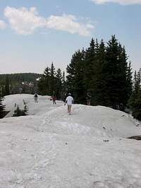 Crag Crest in July.