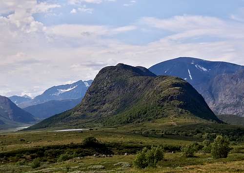
Knutshøe 1517 m is a sharp summit surrounded by an exciting environment, to say the least, located in the South-Eastern sector of the Jotunheimen range included in the Jotunheimen National Park, 350 km North to Oslo, in the middle of Southern Norway. In Norwegian Jotunheimen means "Giants Home" and the reason of this nickname is that the highest mountains in Norway lie here. Knutshøe has a primary factor of 427 m towards the higher Bruskardknappen; it isn't one of the major peaks in this area, anyhow even if its altitude passes just over 1,500 meters Knutshøe is a beautiful mountain to summit and offers more than one reason to be climbed, starting from the interesting crossing route which is described later. The crossing is popular amongst hikers and there is a well worn path across the ridge, anyhow in a couple of places climbing is required. Moreover the summit of Knutshøe generously offers outstanding views towards the peaks towering all around and the surrounding lakes, amongst which the wonderful Gjende lake.
Gjende lake seen from Knutshoe ridge
The high spectacularity offered by the ascent to this summit is due also to the particular charm of the Knutshøe position, close to three lakes, the elongate and well known Gjende lake, the Nedre Leirungen lake and the Øvre Leirungen lake, which beautifully surround Knutshøe. From the sharp ridge it's possible to admire the breathtaking delta landscape down in Leirugsdalen. The spectacular Knutshøe mountain ridge is the minor brother of the adjacent Besseggen ridge. It's so fascinating that many people believes it was the ground for the Peer Gynt deer ride!
Knutshøe seen from Valdresflya
Getting There
The starting point to climb is Vargebakkan parking lot 1100 m (GPS 32V 489770 6811435) along the Valdresflya highway (National Road 51), open in summer.
- By car, you can drive to Vargebakkan parking lot, either via Otta and via Fagerness and Beitostølen, via National Road 51 over the Valdresflya plateau.
From Otta drive Southward on the E6 to Sjoa. In Sjoa leave the E6 and turn right taking the Road 257. At the following junction with the Valdresflya highway (National Road 51) turn to left and drive Southward on the road running along the Sjodalen, passing the Bessheim and the exit to Gjendesheim. The Vargebakken picnic area is located after about 4 km.
- There are direct train services to Otta from Trondheim and from Oslo, and a daily bus service from Otta to Gjendesheim shelter, located nearby.
Knutshøe crossing from Vargebakken
Knutshøe crossing from Vargebakken report
Summit altitude: 1517 m Difficulty: scramble and some easy climbing Vertical gain: 420 m Exposure: South-East, then West Starting point: Vargebakken picnic area
Knutsho seen from Vargebakkan
Truly a worthwhile route inside a breathtaking setting! The route involves a couple of easy climbing spots, one at the start and another one just before the summit. The ridge must be carefully followed without trying to descend along the sides, that are formed by steep cliffs. Being a ring itinerary it's possible to perform it in both directions, but my advise is to follow the way described below, solution allowing to overcome the climbing spots during the ascent and not during the descent.
Wooden footbridge on the way to Knutshoe
Route report - From the Vargebakken picnic area, located at 1100 m along the Valdresflya highway, about 4 km South of the Gjendesheim exit, the trail starts in the North direction. Cross the Varga stream on a wooden footbridge and then overcome a wooden stair which allows to pass through the enclosure, getting soon to a signposted trail junction. Take the right branch, the left one leads to the Leirungsdalen valley, where it runs the return trail. After the junction head to a reddish crag, getting quickly the base of the rock. This is the first climbing stretch of the route. Up the rock, at first on the left, then rightward, and exit on a good trail. Follow it up the ridge.
The wooden stair at the start of the trailØvre Leirungen lake, seen high on the ridge
After passing a trigonometric signal, descend a little, then head rightward following the trail up to the first summit. From the first summit continue along the ridge looking more difficult than really it is. A brief descent with breathtaking views over the lakes all around leads to a saddle below the last prominence of the ridge. Enjoy a superb glance down to the estuary of Leirungsåe stream into Øvre Leirungen lake. Go uphill rightward on steeper terrain, then climb up a short but steep rock spot, giving access to the main summit. The panorama is superb!
The second climbing spot just below the summitThe descent route
Descent - Some people return on the same route - it's the shortest solution - but actually the easiest and more advisable way is to go further in the opposite direction along the ridge and starting the descent in this way. Follow the easy crest and after a stretch a signpost indicates you must head a bit to the right. Further the itinerary provides a superb pano over Gjende lake and Memurudalen. When the descent along the crest ends, the trail heads to left entering the wood close to Øvre Leirungen lake on boggy ground, getting soon a couple of cabins.
Pano over Gjende Lake seen from Knutshoe descent ridge
Follow the trail running in Leirungsdalen between the foot of Knutshøe rock crags on the left and the stream on the right on flat terrain amongst flowers and meadows, getting the signposted junction with the ascent route, past which you join the starting stretch of the trail, coming back to Vargebakken parking lot.
Trigonometric signalLeirungsdalen delta landscapeThe stream along the returnSkirting the crags on the return way
Red Tape
There are no particular restrictions in climbing and hiking. Knutshøe is lying within the superb Jotunheimen National Park, established in 1980, covering an area of 1140 km² and including the 27 highest peaks in Norway. Jotunheimen is located between Oppland and Sogn og Fjordane counties and it's bordered by the great lake called Vågåvatnet, the valleys of Bøverdalen and Leirdalen and the road No. 55 (the mytical Sognefjellveg) to the N and NW, by the Road 51 to the East, by Bygdin, Tyin and Årdal to the South and by the mountain road between Årdal and Turtagrø to the West.
Parents refers to a larger category under which an object falls. For example, theAconcagua mountain page has the 'Aconcagua Group' and the 'Seven Summits' asparents and is a parent itself to many routes, photos, and Trip Reports.

 12504 Hits
 85.22% Score
 20 Votes