
|
|
Mountain/Rock |
|---|---|
|
|
39.14500°N / 106.582°W |
|
|
Pitkin |
|
|
Hiking, Mountaineering |
|
|
Summer, Fall |
|
|
13380 ft / 4078 m |
|
|
Overview

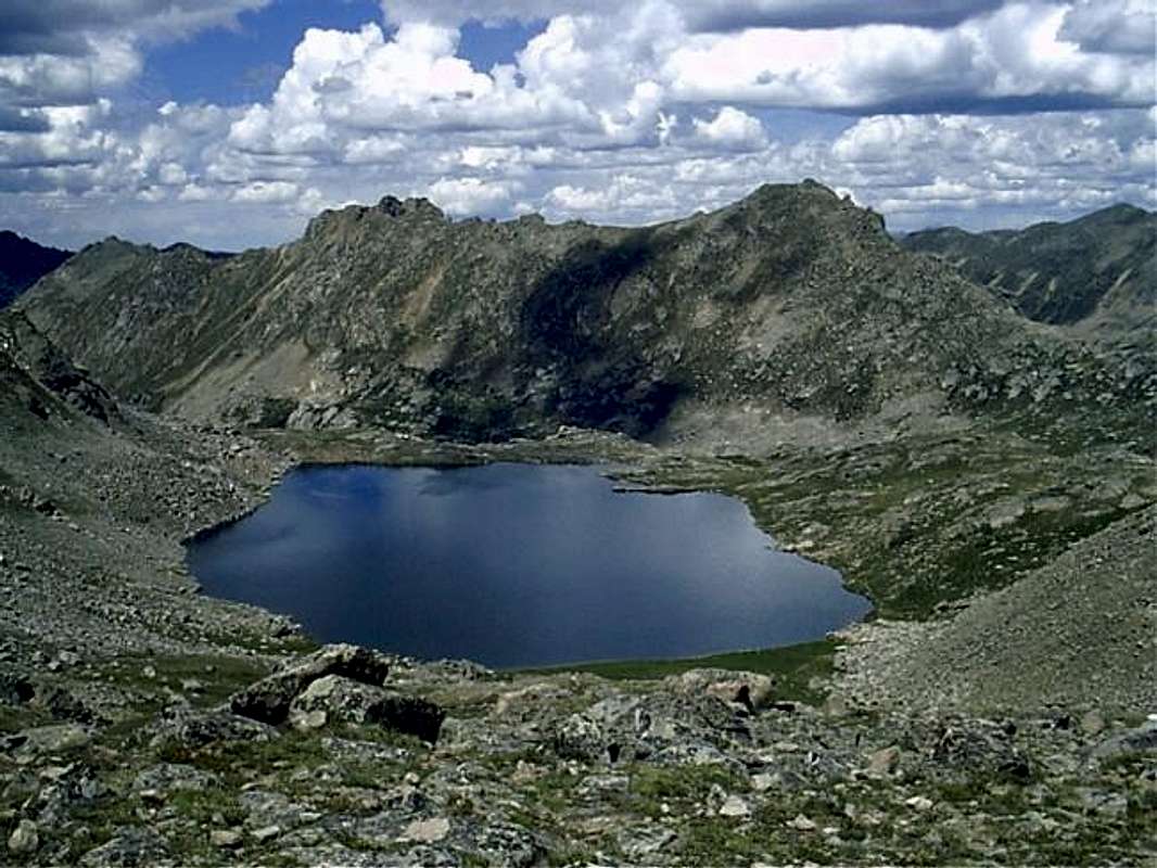
Geissler Mountain East from Point 13,150
Photo by Kane
Geissler Mountain East is located high in Colorado’s Sawatch Range, about six and half miles west-northwest of Mount Elbert (Pic). Geissler East is located in the Hunter-Fryingpan Wilderness, within the White River National Forest. Geissler Mtn. East has a sister summit immediately to the WSW, aptly named Geissler Mountain West. Geissler East is taller at 13,380, while Geissler West rises to 13,301. Both summits are ranked Thirteeners. The Geissler Mountain "Massif" also includes a lesser (and non-ranked) southwest summit, which rises to 13,186 feet. While not being one of the state’s greatest peaks, Geissler is a fun and quite worthwhile hike. The accent of the east summit consists of class 2 climbing, while harder routes can be found. The view from this small summit is amazing—in one direction loom Elbert and Massive, while in the other the legendary Elk Range (Pyramid, Maroon Bells, Snowmass, Capitol, etc.). The peak is easy to access due to its proximity to CO Highway 82. This allows it to be climbed with minimal time devotion. Geissler is a nice mountain to climb for people who are looking for an introduction to climbing the higher mountains of the Colorado, or for visitors to Colorado needing some acclimatizing before going after higher mountains. From what I could surmise from the summit register, this mountain sees relatively little traffic, about one group a week or so.
UN 13,001, Colorado’s lowest ranked Thirteener rises above Lost Man Lake
Lost Man Trail (Lost Man Loop) encircles the mountain and provides a nice tour of the glacial basins of Lost Man Creek and the Roaring Fork River.
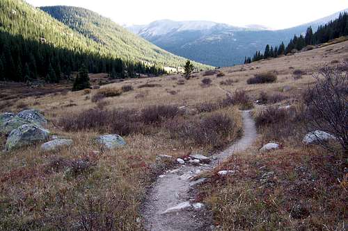
Lost Man Trail and the
Hunter-Fryingpan Wilderness
Getting There
The upper (east) trailhead of Lost Man Trail provides the most direct access to the mountain. The lower (west) trailhead across the highway from Lost Man Campground is further away and provides a longer approach hike. Directions are to the upper trailhead.From Aspen: drive 18.5 miles east of Aspen on Colorado Highway 82 to the switchback where the road crosses the Roaring Fork River, the trailhead parking is on the north side of the road.
From Twin Lakes Reservoir south of Leadville: Drive west on Colorado Highway 82 to Independence Pass. Continue past the pass for 1.9 miles to the switchback where the road crosses the Roaring Fork River, the trailhead parking is on the north side of the road. The lower trailhead is 4 miles down the road to the east.
 |  |  |  |
Red Tape
Colorado Highway 82 over Independence Pass is closed November through May (Memorial Day). The Hunter-Fryingpan Wilderness is open year round, but access to the area is difficult when Highway 82 is closed. No permits or fees are required to climb the mountain or hike Lost Man Trail. Parking at the trailheads is free.Hunter-Fryingpan Wilderness
White River National Forest
To check the status of CO 82 Independence Pass click here
When To Climb
Late June-July through September is when to climb if you don’t want to be on snow. Obviously, a September snowstorm would change this.As the Highway is closed from late autumn through late spring, approach during this time would have to be creative (not to mention energy and time consuming). You are probably better off climbing something else that is more accessible.
Camping
Camping is allowed in the Hunter-Fryingpan Wilderness. No fees are charged. Do expect the possibility of stove only regulations.Lost Man campground is across the Highway from the lower (west) trailhead. A fee of $15 is required per night.
Lost Man Campground
Mountain Conditions
For weather conditions and forecasts go to National Weather ServiceThe Weather Channel Has weather conditions and forecasts for Aspen.
Keep in mind that you are several thousand feet higher than Aspen.
For information about conditions in the White River National Forest contact the Aspen Ranger District contact info here
Web Cams
Have a look at conditions in Aspen:
Click Here for a live cam.
Aspen-Snowmass Pano Mountain Cams
Google Map
View Larger Map
External Links
- Hiking in Colorado—Geissler Mountain
Old web page, may be of some interest.
- Rocky Mountain Scenery
Some nice pictures of the area