|
|
Mountain/Rock |
|---|---|
|
|
45.89050°N / 7.68430°E |
|
|
10938 ft / 3334 m |
|
|
Overview
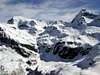
Monte Roisetta is a double headed mountain. N summit is 3334 mt. o.s.l. and S summit, is 3.324 mt. o.s.l.99,9% of people celebrate its conquer on the S summit, easily reachable, but the main top is just 400 meters N direction, after a delicate ridge of unstable rocks. In both cases, there aren't climbing difficulties. The final ridge for the main summit can be slippery with snow and ice. Take care!
Monte Roisetta is a wonderful balcony on Matterhorn and Monte Rosa group. Breathless scenes can be lived even on S summit (this to confirm why 99,9% people stops there!).
Monte Roisetta is an excellent "second-choice", instead of the more difficult Grand Tournalin.
 |  |  |
Getting There
ROUTE FOR CHENEIL (car park), VALTOURNENCHEComing from Switzerland: drive toward Aosta direction. Then follow A5 motorway, Turin/Milan direction. Get out from A5 at Chatillon/Saint Vincent.
Coming from France (Mont Blanc or Petit St. Bernard): drive toward Aosta direction. Once passed Aosta, forward to Chatillon/Saint Vincent exit.
Coming from Turin/Milan: drive on A5 motorway following Aosta direction. Get out from A5 at Chatillon/Saint Vincent.
Common route in Valtournenche. Once arrived in Chatillon, follow Cervinia direction, onto SR46 (Strada Regionale 46). Once arrived in Valtournenche village (Valtournenche is not only the name of the valley), before arriving at the Cable Way, turn right (there is a big panel with more than 20 villages names). The most visible panel is for "Hotel Tersiva". Drive to Cheneil direction (always "the main" road), until the road ends in a paved parking, free of charge.
There are two useful waypoint for your route GPS:
1) N45 52.876 E7 37.442 - right turn in Valtournenche for Cheneil
2) N45 52.035 E7 38.558 - car park in Cheneil. Cheneil is just 15 minutes walk, over the ugly parking.
All hikes in Cheneil begin at 2,023 mt o.s.l. (car park).
 |  |
When To Climb
In summer: from late June to early fall (it depends on snow conditions). Generally snow could remain, on southern main slope, until July.In winter (ski-mountaineering): from half March to May. Perfectly assested snow is required.
 |
Miscellaneous Info
You can check present conditions by webcams on http://www.regione.vda.it/turismo/webCam_i.asp (look for Valtournenche).Books and Maps
IGC, foglio 108 (Cervino Matterhorn Breuil Cervinia Champoluc), scale 1:25.000Hotel/Camping in Valtournenche
Hotel Panorama Bich, loc. Cheneil, 5, Valtournenche - 0039.0166.92019. Open in Spring and Summer. Call for a reservation! 20 beds.Other hotel: 91 hotels (* to *****) available in Valtournenche/Breuil Cervinia area. Locate your favourite with
www.paginegialle.it
Camping Glair - Località Glair, 6, Valtournenche - 0039.0166.92080.
Warning: free camping is allowed in Val d'Aosta, only over 2,500 mt o.s.l., from sunset to dawn.
Talk about Monte Roisetta?