
-
 10392 Hits
-
 89.39% Score
-
 29 Votes
|
|
Mountain/Rock |
|---|---|
|
|
45.58834°N / 7.26574°E |
|
|
Mountaineering |
|
|
12083 ft / 3683 m |
|
|
Overview
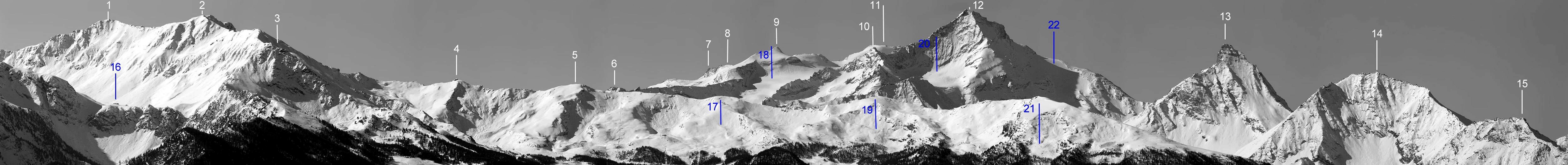
The Punta Nera (Black Top) is part, together with the Rossa (Red) and Bianca (White) of the triptych in the SE side of the more famous Grivola; the 3 summits have, to the North, glacial slopes while, on their Southern side have ruined rock walls. This Summit, placed at the top of three valleys (Trajo and Lauson in Cogne Valley and Leviona in Valsavarenche) is a very fine panoramic hike/climb and a good ski-mountaneering goal.
La Punta Nera fa parte, insieme alla Rossa e alla Bianca, del trittico a Sudest della ben più famosa Grivola; le tre presentano versanti glaciali a Settentrione, ammantati dal Ghiacciaio del Trajo, mentre a Mezzogiorno sono caratterizzate da pareti di roccia in rovina. Situate al vertice di tre valloni (Trajo e Lauson in Val di Cogne e Leviona in Valsavarenche), è un'ottima gita panoramica e anche sci-alpinistica.
First Ascents
- First on the summit: W. A. B. Coolidge, G. Yeld, Chr. Jun. and R. Almer, (Aug 08th, 1888).
- In winter: Ettore Giraudo, Giuseppe Giraudo and Angelo Rivera, (Mar 10 th, 1940).
- NE Arête (normal route): Giovanni Bobba and Casimiro Thérisod, (Jul 07th, 1890).
- S-SE Arête: Giovanni Bobba and Casimiro Thérisod, (Jul 17th, 1890), in descent.
- S Wall and W Arête: G. B. Origoni, G. Origoni and G. L. Blanc, (Sep 03th, 1890), in descent.
- W Arête : W. A. B. Coolidge, F. Gardiner, Chr. Jun. and R. Almer, (Aug 12th, 1889), in descent.
- N Wall (direct): A. Adami, C. Bianco, A. Coppa, V. Marcoz and Remo Chabod, (Aug 27th, 1937).
![]()
Getting There
BY CAR:- From Torino, Milano, etc: Motorway A5. Exit at Aosta Ovest. Drive to the near Aymavilles. Follow the directions for Valle di Cogne.
- From Switzerland: through the Grand Saint Bernard Tunnel or the namesake Pass. Drive to Aosta, then follow the direction for Courmayeur on SS.26. Just after Sarre, turn to the left, in the direction of Valle di Cogne.
- From France: through Mont Blanc Tunnel or Petit St. Bernard Pass. It isn't necessary to take Motorway A5: you can drive on SS.26, in the direction of Aosta.Before arriving at the Village of Sarre, turn right following the sign for Valle di Cogne. After Aymavilles, the SR.47 crosses the Villages of Vieyes, Epinel and Cretaz and after about 25 Km arrives at Cogne (1.534m). From Cogne you can get the Village of Valnontey (1.666m).
- Aeroporto "Corrado Gex" Saint Christophe (Aosta).
Route
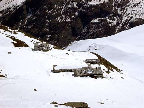
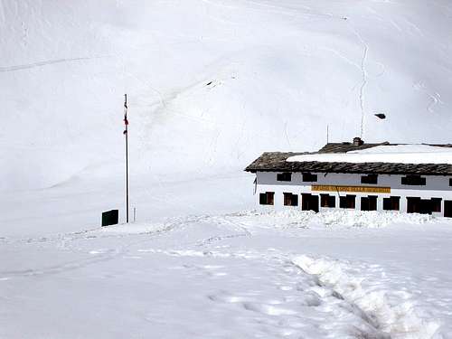
From Valnontey (1.674m) cross the wooden bridge over the Valnontey Stream to get the "Giardino Alpino Paradisia", on the path of the Alta Via n° 2 and go on up to the Rifugio Vittorio Sella (2.579m - 2h'30). Follow toward the Colle Lauson (3.296m) until the fork (2815m) the turn to the North along the path that, with narrow hairpins, leads to the Colle della Rossa. Once at the Plan de Tsalende turn towards West (3.094m) and along tracks go to the small Glacier of Rayes Noires, cetween the Punta Nera and the Becca di Verminana. Walking under the walls of the Punta Rossa and of the Quota 3.562, turn to the West-southwest to get, at about 3.300m, the glacier and up to the notch (3.421m). Now along the South-southeast Ridge, in the beginning on debris then on square big stones, building a series of towers (I°, II° following the edge) leading to the Summit (5h'00/6h'00).Descent: Along the east Northeast Ridge down to the Colle della Nera (3.487m) then along a channel slanted to the left and leading to the Plan de Tsalende.
Da Valnontey (1.674 m) raggiungere, dopo aver oltrepassato il ponte in legno sul Torrente Valnontey, il "Giardino Alpino Paradisia"; sul sentiero dell’Alta Via n° 2 risalire al Rifugio Vittorio Sella (2.579 m; 2h'30). Continuare verso il Colle Lauson (3.296 m) sino al bivio (2.815 m), ove si svolta a Nord prendendo il sentiero a stretti tornanti per il Colle della Rossa; giunti al Plan de Tsalende prendere il bivio verso Ovest a quota 3.094 metri e, su tracce di sentiero indirizzarsi verso il minuscolo Ghiacciaio des Rayes Noires, tra la Punta Nera e la Becca di Vermiana. Passando sotto le pareti Sud della Punta Rossa e della Quota 3.562 m, svoltare gradualmente a Ovest-sudovest in direzione del ghiacciaio, che si raggiunge sui 3.300 metri; risalire ancora sino a raggiungere l'omonimo colle (3.421 m). Da questo risalire la Cresta Sud-sudest su detriti e roccette prima e su blocchi squadrati costituenti un torrione dopo verso l'alto (I°, sul filo II°) prima della Cima (5h'00/6h'00).
Discesa: Per la facile Cresta Nordest al Colle della Nera (3.487 m) e da questo per un canale obliquo a sinistra che riporta al Plan de Tsalende.
Difficulties
Difficulties: F+ (UIAA).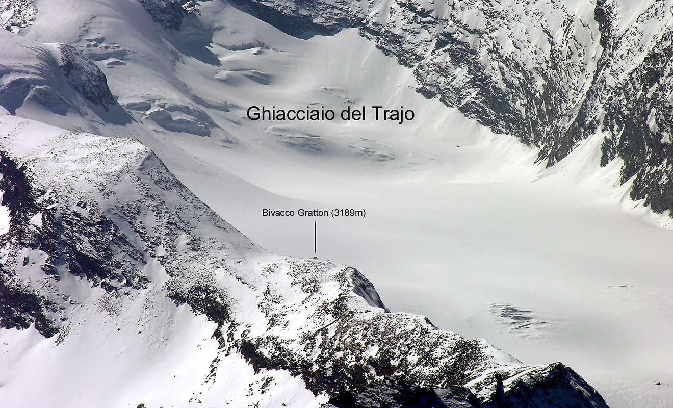
Da alta montagna.
MAPS:
Huts
- Rifugio Vittorio Sella (2.584 m) Conca di Lauson (Cogne) Tel.: 0039/0165/74310 eMail: info@rifugiosella.com
![]()
![]()
Campings
- Wild camping in the Parco Nazionale del Gran Paradiso is strictly forbidden!!!
Mountain Condition
- Meteo: you can find all the needed informations at the official site of the Valle d'Aosta Region:
- Valle d'Aosta Meteo
- Meteo: You can find more weather information on the website 3B Meteo:
- Meteo Cogne
- Meteo: You can find more weather information on the website 3B Meteo:
- Meteo Valnontey
Webcam
- WEBCAM on Aosta Valley:
- Webcam
Red Tape
Within the borders of the P.N.G.P. (Parco Nazionale del Gran Paradiso), at the moment (summer 2004), dogs generally are not allowed, except on a couple of trails, and camping is forbidden (except for climbers from sunset till dawn). No fees are due.Books and Maps
BOOKS:- "Guida dei Monti d'Italia-Gran Paradiso Parco Nazionale" E. Andreis, R. Chabod, M. C. Santis, Club Alpino Italiano/Touring Club Italiano, prima Ed. 1939; seconda Ed. 1963; terza Ed. 1980.
- "A piedi in Valle d'Aosta" (Vol. 2), di Stefano Ardito, Ed. Guide iter, Giugno 2004.
- "Parco Nazionale del Gran Paradiso" di Stefano Ardito, Ed. Guide iter, Novembre 2001.
- "Guida delle Alpi Occidentali", di Giovanni Bobba e Luigi Vaccarone C.A.I. Sezione di Torino Volume II (parte II), 25 Maggio 1896.
- "80 itinerari di Escursionismo Alpinismo e Sci Alpinismo in Valle d'Aosta", di Osvaldo Cardellina, Ed. Musumeci, Giugno 1977 (in Italian); seconda Ed. Luglio 1981; terza Ed. Luglio 1984; (in French), prima Ed. Febbraio 1978; seconda Ed. Marzo 1980.
- "Diari Alpinistici" di Osvaldo Cardellina e Indice Generale accompagnato da Schedario Relazioni Ascensioni 1964-2019 (inediti).
- "Rifugi e bivacchi in Valle d'Aosta", di Cosimo Zappelli aggiornata da Pietro Giglio, Musumeci Editore, Luglio 2002.
- "Guida della Regione Autonoma Valle d'Aosta" di Mario Aldrovandi, Ed. S.P.E. di Carlo Fanton, Torino 31 Dicembre 1964.
 |
 |
 |
 |
 |
- Kompass "Gran Paradiso Valle d'Aosta Sentieri e Rifugi" Carta Turistica 1:50.000.
- Enrico Editore Ivrea-Aosta "Gruppo del Gran Paradiso" 1:50.000.
- L'Escursionista "Valle di Cogne Carta dei Sentieri" 1:25.000.
- L'Escursionista "Tour de la Vallée de Cogne Grand Paradis" 1:25.000.
- I.G.C. Istituto Geografico Centrale "Parco Nazionale del Gran Paradiso" 1:50.000.
- Studio F.M.B. "Gran Paradiso" Bologna 1:50.000.
Important Information
- REGIONE AUTONOMA VALLE D'AOSTA the official site.
- FONDAZIONE MONTAGNA SICURA Villa Cameron, località Villard de la Palud n° 1 Courmayeur (AO) Tel: 39 0165 897602 - Fax: 39 0165 897647.
- SOCIETA' GUIDE ALPINE DI COGNE Tel. 347/9473526 – 328/1373728.
- A.I.NE.VA. (Associazione Interregionale Neve e Valanghe).
- A.IA.T. Cogne Gran Paradis via Bourgeois n° 34 Tel. 0165-74040. E-mail: aiat@cogne.org
- Ezio Sport articoli sportivi - via Bourgeois n° 64 Tel. 0165-74204.
Useful numbers
- Soccorso Alpino Cogne (SAR) Tel. 3482685406.
- Protezione Civile Valdostana località Aeroporto n° 7/A Saint Christophe (Ao) Tel. 0165-238222.
- Bollettino Meteo (weather info) Tel. 0165-44113.
- Bollettino Valanghe Tel. 0165-776300.
- Unità Operativa di Soccorso Sanitario Tel. 118.