
-
 9418 Hits
-
 85.87% Score
-
 21 Votes
|
|
Route |
|---|---|
|
|
37.84917°N / 107.15033°W |
|
|
Ice Climbing |
|
|
Winter |
|
|
Half a day |
|
|
1 |
|
|
Overview
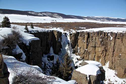
North Clear Creek Falls are located about halfway between Lake City and Creede.
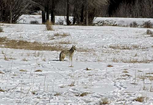
Coyote Canis Latrans - photo taken just outside Lake City.
North Clear Creek Fall is located in a remote area, about 24 miles southeast of Lake City. It is a great place to visit, especially if you get tired of the Lake City’s Ice Park, or if you wish to have a more adventurous outing and solitude. The approach is trivial, there is no avalanche danger, and it is an easy ice fall, rated as WI3+. You can top rope it, or lead it, and you can bring your family to watch from the overlook just above the falls.
This climb is located between Lake City and Creede (roughly half way between those towns) in San Juan Mountains. Please don’t confuse with Clear Creek Canyon ice climbing outside of Golden. I guess too many creeks share this name.
There is also South Clear Creek Waterfall located only 4 miles from North Clear Creek Waterfall. Both can be easily climbed in one day. We had a problem that my climbing partner forgot his ice climbing boots and got cold, so we climbed only the North Clear Creek Falls.
Both falls North and South Clear Creek are easy, rated as WI3 (South Fall being easier and shorter) and both can be toproped. In fact, you approach both waterfalls from the top, and you rappel down to its bottom.
The area is very isolated and both towns: Lake City and Creede are small (both have population of less than 500). There are accommodations in both towns, but not mountaineering/climbing shops. Lake City is becoming known for its Ice Park (link above) and offers more in regards to motels/restaurants during the winter time.
North Clear Creek Waterfall area is very popular in the summer. Creede's website claims those are the most photographed waterfalls in Colorado. For birders, the main attraction is the nesting colony of Black Swifts, which are difficult to see. You should be able to see American Dippers.
Elevation: falls are 10,050 feet at its top
Getting There
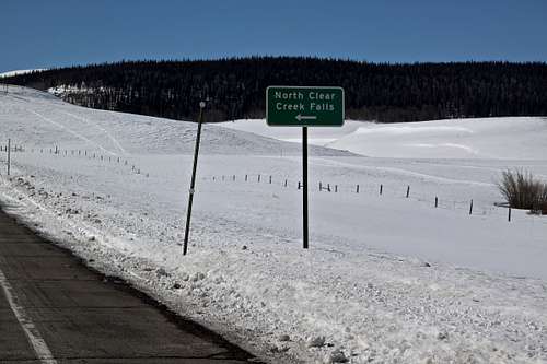
Beta photo - North Clear Creek Falls are well marked. Hwy 149, about 24 miles southeast of Lake City.
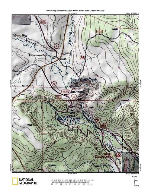
TOPO
Drive south on Hwy 149, the road climbs up above Lake San Cristobal, look back - you will have great views of Uncompahgre Peak, pass over Smugmullion Pass, and Spring Creek Pass. At mile marker 49, about 24 miles from Lake City (Jack Roberts mentions only 21.5, which got us confused. We got to 21.5 miles and did not see any turn off or sign for falls, and turned around thinking we missed it). Anyway, there is a large sign for the North Clear Creek Falls, and right before the sign there is a parking area on the west side of the road. This parking area is big and very popular with snowmobiles.
The distance from Creede is 22.4 miles.
We chose to park at the parking area, although it was possible to park closer on the shoulder of the road. Hike about 1/4 mile along the road to the turn off for Falls, which was well marked. Follow the snow plowed FR 510 for 0.5 miles to the obvious picnic area with vault toilets. There is a nice overlook providing great views of the falls.
We did not need any skis for the approach, the road would be perfect for cross country skiing. Nor did we need snowshoes (I had those ready in the car, but the road was packed hard).
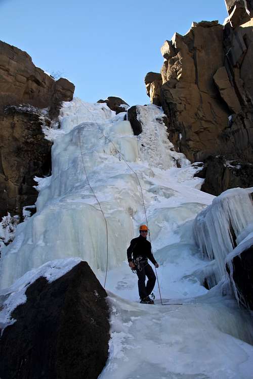
The vault toilets were open and supplied with paper. There was no sign of anyone breaking a trail towards the falls. We broke trail in a deep snow along the western end of the gorge to the top of the waterfall. It was easy to spot two bolts at the top of the fall.
Route
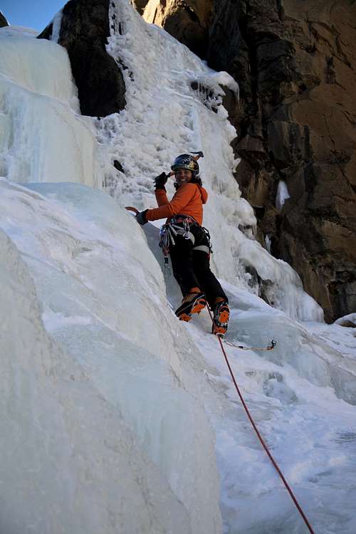
Easy leading on North Clear Waterfall WI3.
Easy looking icefall
The waterfall is described as WI3+ in Jack Roberts Colorado Ice. You can make a few variations from WI2 to WI3/4 (the WI4 sections being short). The ice fall can be top roped or lead, and if something would happen there is an option to hike out of the gorge relatively easily.
It is a great area to bring your family - they can sit at the viewing spot by the picnic area and take great photos of your climbing.
The climb is only 35 meters long. The ice seemed untouched, no steps formed or other signs of anyone climbing there. The ice was thin at the center - only about 5 cm thick and once I poke through and got showered with an icy water running below.
You can easily cross country ski or snow shoe here. It can be an activity for non-climbers too.
South Clear Creek Falls - as I mentioned above, we did not visit these since my partner forgot a layer of thermal underwear and his ice climbing boots (he improvised and attached crampons to his hiking shoes with little bungie cords, but got really cold and the system did not work that great). These falls are located 3 miles south on Hwy 149 from North Clear Creek. Again, there is a sign on the road. This waterfall is only 25 meters long and is rated as WI3.
Red Tape
The parking and climbing are free. Pets are welcome and should be on leash. The overlook is often used for snowmobiling.When to Climb and Equipment
Most climbs in this area get formed around late November and last through March. You can try to call Lake City Ice Park to see whether they have information about this climb, otherwise you may have to risk and drive to check it out yourself.Equipment - try not to forget it, there are no places to buy any climbing gear around.
Consider bringing skis/snowshoes if there was fresh snowfall, otherwise the road should be snow plowed and packed, easy to follow just in hiking/climbing boots.
- Climbing gear - personal gear: harness, boots, crampons, ice tools, helmet.
- Rope: 70 meter is better, but 60 meter will do (the easier side is 35 meters long, the steeper is only 25 meters long).
- Anchors are only 2 bolts, so bring some draws and carabiners.
- Ice screws if you plan to lead - this ice fall is great for a beginner leader.
 Approach to falls from Hwy 149 Approach to falls from Hwy 149 |  FR 510 FR 510 |  Deep Snow close to the falls Deep Snow close to the falls |  Bolted Anchors Bolted Anchors |  Rappel Rappel |
 Base of the fall Base of the fall |  Don't forget your boots! Don't forget your boots! |  Abalakov - fun practice Abalakov - fun practice |  Climbing Climbing |  Little steeper on the left Little steeper on the left |
Camping
North Clear Creek Campground is closed in the winter. I can't imagine anyone causing problems if you wish to snow camp at the picnic/overlook area above the falls. Vault toilets are open year round.
And some historical information
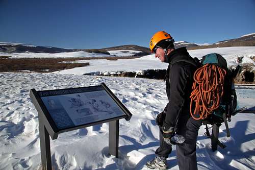 Informative kiosk about Folsom culture and the view of the gorge in the background.
 Bristol Head is a summit in Mineral County in Colorado. Elevation: 12,713 feet (=3,875 m)