Routes


East Tyrol (Venediger group), Austria, Europe
32 miles away
Route Type: Hiking, Mountaineering, ScramblingDifficulty: Medium hard marked route.
Parents: Rostocker Egge


Germany, Europe
32 miles away
Route Type: Scrambling, Via FerrataGrade: I
Parents: Sulzleklammspitze Karwendel


Bavaria / Tyrol, Austria, Europe
32 miles away
Route Type: Mountaineering, ScramblingDifficulty: UIAA II - III-
Parents: Grosse Arnspitze Arnplattenspitze


Tyrol, Austria, Europe
33 miles away
Route Type: Via FerrataDifficulty: Grade C
Parents: Sellrainer Berge


Dolomites, Italy, Europe
33 miles away
Route Type: Via FerrataDifficulty: Easy rock climb, Medium hard ferrata
Parents: Gran Cir / Grosse Cirspitze


Südtirol / Alto Adige, Italy, Europe
33 miles away
Route Type: Hiking, ScramblingDifficulty: Hike and Scree Scramble
Parents: Grosser Rosskopf / Campo Cavallo Herrenstein / Sasso del Signore

Südtirol / Alto Adige, Italy, Europe
33 miles away
Route Type: HikingDifficulty: Hike
Parents: Grosser Rosskopf / Campo Cavallo

")
Italy, Europe
33 miles away
Route Type: Trad ClimbingDifficulty: IV+
Grade: III
Rock Difficulty: 5.6 (YDS)
Parents: Sass da Ciampac
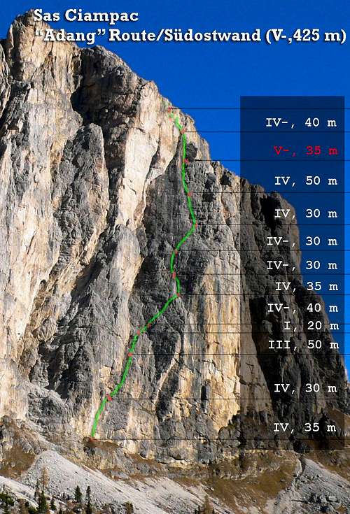
Italy, Europe
33 miles away
Route Type: Trad ClimbingDifficulty: UIAA V-
Grade: III
Rock Difficulty: 5.7 (YDS)
Parents: Sass da Ciampac


Tyrol (Ötztal), Austria, Europe
33 miles away
Route Type: Ice ClimbDifficulty: 50°
Parents: Ramolkogel


Bolzano - Alto Adige, Italy, Europe
33 miles away
Route Type: HikingDifficulty: EE
Parents: Sass da Ciampac

Tyrol, Austria, Europe
33 miles away
Route Type: MountaineeringDifficulty: F, UIAA grade II
Parents: Hochwilde (Hohe Wilde) / l'Altissima
Dolomites, Italy, Europe
33 miles away
Route Type: Classical Rock ClimbDifficulty: Up to V
Parents: Sassongher (Sass Songher)

Dolomites, Italy, Europe
33 miles away
Route Type: Hike / FerrataDifficulty: KS1-B
Parents: Sassongher (Sass Songher)

Dolomites, Italy, Europe
33 miles away
Route Type: Hike / FerrataDifficulty: KS1-B
Parents: Sassongher (Sass Songher)

Salzburg / Tyrol (Venediger group), Austria, Europe
33 miles away
Route Type: Hiking, Mountaineering, Ice Climbing, Mixed, Scrambling, SkiingDifficulty: Basic Glacier Climb 45°, Rock climbing UIAA I-II,
Parents: Grosser Geiger
South Tyrol / Alto Adige, Italy, Europe
33 miles away
Route Type: HikeDifficulty: Walk-Up
Parents: Hochstein and Rischterpfarrer
South Tyrol / Alto Adige, Italy, Europe
33 miles away
Route Type: Hike and ScrambleDifficulty: Walk-Up
Parents: Hochstein and Rischterpfarrer

East Tyrol (Venediger group), Austria, Europe
33 miles away
Route Type: Hiking, Mountaineering, Ice Climbing, Mixed, ScramblingDifficulty: Basic Glacier Climb and in the upper part steep scrambling, UIAA I-II on some parts
Parents: Grosser Happ
East Tyrol (Venediger group), Austria, Europe
33 miles away
Route Type: Hiking, Mountaineering, Ice Climbing, Mixed, ScramblingDifficulty: Basic Glacier Climb and in the upper part steep scrambling, UIAA I-II on some parts
Parents: Grosser Happ


Otztal Alps, Tirol, Austria, Europe
33 miles away
Route Type: Hiking, Scrambling, Via FerrataDifficulty: UIAA I graded Via Ferrata
Parents: Nordlicher Polleskogel Südlicher Polleskogel

Süd-Tirol / Alto Adige, Italy, Europe
33 miles away
Route Type: MountaineeringDifficulty: F, UIAA grade II
Parents: Lodner / Cima Fiammante
")


Austria, Europe
34 miles away
Route Type: Mountaineering, Ice ClimbingDifficulty: ZS/ ice 45-55°
Parents: Hinterer Spiegelkogel