
|
|
Area/Range |
|---|---|
|
|
27.10611°S / 68.53944°W |
|
|
Mountaineering |
|
|
22615 ft / 6893 m |
|
|
The Puna is a high altitude area in Argentina and Chile where most of South America's highest peaks are located. If you have a look at the top ten list of the peaks of Argentina and Chile, it's only Aconcagua (number 1) and Mercedario (number 7) which qualify amongst all the giants of the Puna.
Most of those mountains are easy climbs as far as technical difficulty goes and most can be summited without much prior mountaineering skills. On the other hand, the Puna has a rough climate with ferocious winds, the average altitude is very high (in some parts over 5500m) and the lack of water makes climbing here a tough venture.
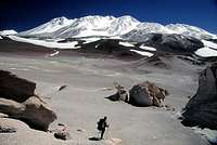
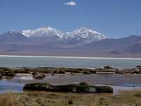
The vaste spaces and barren landscape adds to the feeling of a real adventure. Bright colored lagoons, perfectly shaped volacanoes and some unusual wildlife have a magnetic power on and climbers who have been there once tends to come back for another visit.![Enormous penitentes fields on...]() Penitentes fields. Here en route to Pissis East.
Penitentes fields. Here en route to Pissis East.
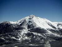
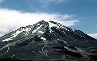
The highest volcano on earth, Ojos del Salado is found here, which also is the highest peak of the Volcanic Seven Summits. Some of the volcanoes of the Puna is classified as active, but the notable activity is usually restricted to some smell of sulphur and sometimes some of the peaks lets out a little fume, locally called "fumoroles".![The last pass before you head...]() The desolation in the ara. Great distances to cover.
The desolation in the ara. Great distances to cover.
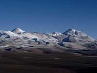
Starting from the south, the first high peaks you are likely to see are those north of Laguna Brava. Bonete Chico, Veladero, Baboso, Reclus and Pissis are the ones over 6000m.
North of the Pissis massif some more 6000ers are scattered a bit here and there. Copiapo, Tres Quebradas are two. Further north and north west most of the really high peaks are to be found. The Tres Cruces group, Nacimiento, Cazadero, Solo, Olmedo, Vicunas, del Viento, Ojos del Salado and El Muerto are all quite close to each other and if there's a heart of the Puna, it's here.
In the area around Paso de San Francisco there are more high peaks. El Fraile, Incahuasi, San Francisco, El Condor, Ermitaño, Peña Blanca, Barrancas Blancas and Laudo are the highest.
On the large completely unihabited area further north there are some more peaks over 6000m scattered over a large area. Antofalla, with its many summits and Vallecitos are over 6000m.
Many regard the area around Socompa to be the northern end of the Puna. There you'll find the massive Llullaillaco, Socompa, Pular, Salin and Aracar, all over 6000m.
Some also count the area around Cachi to the Puna, but as the area in general is quite different from the other parts of the Puna, I have chosen to exclude it.
The Puna is quite infamous for very hard winds and the few times it rains, it usually arrives in the company of thunder and storm. That said, the weather patterns are quite stabile and if there's good weather it can hold for longer periods of time.
It's a hot and dry area under normal conditions and don't surprised if you sweet a lot cursing the heat daytime and shivering from cold as soon as the sun has set.
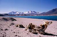
The area is extremely dry and this can cause skin problems. Be sure to bring some good lip balm and/or some moitering cream. The sun is strong and unfiltered on the high altitude and good sun block is a most. If an animal dies here, it gets mummified quickly.![Laguna Verde - Resting before...]() Mummified animal at Laguna Verde
Mummified animal at Laguna Verde
Water
Water can be a real issue. Over 5000m it's usually not a problem. You can find penitentes fields and areas with snow, but even this can be a problem as the area has the highest snowline in the world and Incahuasi is supposedly the highest mountain on earth without any permanent snow. In some areas, namely the northern access to Pissis you have to be very careful with the water as it is said to contain arsenic.
Ask the locals where you can find water before taking off and if they tell you there may be water, but salty or brackish, it's usually undrinkable.
None!
You can climb any peak without any permits.
Sometimes the gendarmeria or border guards want to register you. This is for your own safety.
The provincial government of San Juan wanted to put permit fees and other restrictions in the area. These included: you had to go with an official vehicle from the tourist department in San Juan, you had to have a guide and other stupidities. Fortunately the local organizers complained so much this never happened.
Chile
You need a permit from DIFROL.
See here for general rules.
Here for which peaks you need a permit for.
In addition to this, you have to have a climbing permit for Ojos del Salado. At the time writing the fee is US$160, unless you're Chilean, then you only pay US$50.
Here's the deal.
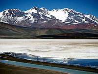
![Laguna Verde [9 Dec 2000]]() Another common feature of the Puna - bright colored, salt water lagoons.
Another common feature of the Puna - bright colored, salt water lagoons.
The distances in the area are large and there are basically no settlements. There are few roads and most of the existing ones are rough dirt tracks. On the other hand, a good 4x4 can usually find its way around, even completely offroad the few present obstacles. Deep sand and large rocks in narrow canyons can stop you though. To go by a 4x4 vehicle is many times the only option, unless you like long, dry and hard walk-ins. Services with mulas are almost non-existent except for the area around Ojos del Salado.
If you want to have the warmest weather, head for the area in the South American summer time, i.e. December through March. Some climbers choose to go later in the season, in April, May, October and November when the water accces is better. The winter months can be bitterly cold and I haven't heard of any climbs in between June and September.![The refugios en route are...]() Ancient refugio en route to Laguna Brava, Argentina.
Ancient refugio en route to Laguna Brava, Argentina.
You can camp anywhere on the Puna. No restrictions. Make sure you bring a good 4-season tent, or it may be blown to shreds by the winds in the area. Also, sturdy pegs and a tent with storm/snow mats is recommended. Sometimes the ground can be very hard.
There are very few refugios or huts. There are two on the Chilean side of Ojos del Salado, but you may only be allowed to stay in one of them (Tejos). There's a very basic refugio en route on the Argentinian side as well.
Apart from those, there are only the refugios along the roads, which mainly are set up as shelters for motorists in trouble. You can stay in these spartan huts for free. The most interesting ones are those en route to the Veladero and Bonete Chico area. Built out of rocks in the year of 1873 they are worth a visit. The one at Laguna Brava is supposedly inhabited by ghosts and there's a skeleton under the rocks, right outside the entrance of the hut.![Nevado Tres Cruces - main...]() Vegetation on the Puna. Not much more than this.
Vegetation on the Puna. Not much more than this.
The far most common animal is the vicuna, a species in the llama family. These are seen on a daily basis almost all over the Puna up to 5000m. Usually the walk in small groups. Interesting is, the group has a leader which warns the others with loud and shrill sounds.
Foxes are seen at occasions and so are some small hole digging rodents. Birds of pray are quite frequently seen, but apart from thos, the skies are surprisingly empty. Lizards and chamelions are seen in the warmer, lower valleys.
There isn't much growing in the area. Some rugged grass and very low plants can be found, but no bush or trees survive in the rough climate.
Going to the southern part of the Puna, you can find local help with tranport etc. in the little town Villa Union. Ask in any of the offices located around the main square.
The Mercedario specialist, San Juan Aventura can also arrange tours and expeditions for the area.
Both the above organizers can also help you with expeditions on the Chilean side and it's probably cheaper as basically everything is more expensive on the western side of the border.
A little warning.
The Puna is getting more and more popular and there are many companies offering tours there. Many of them hasn't been there and I encountered some expedition leaders who didn't knew more about the area than their clients from the other side of the globe.
Ask for references from earlier expeditions. My recommendation is also to choose local organizers. Nowadays there are many from outside the area offering guiding and transport, but you better use the local guys as they know the area much better.
If you have any info about good Chilean organizers, please let me know!
Vincina, depending on how picky you are, further down the road can also be an alternative. Both places have tourist information offices, hotels, internet, gas stations and restaurants.
For the rest of the Puna further north, Fiambalà is the obvious choice. The cozy little town has all the above mentioned services and also some very nice thermal springs. If you're a little bit picky with food it might be better if you buy some of the food in a larger town before arrival. La Rioja or Catamarca are large cities with good supermarkets and "Supermercado Delfin" at the main square in Tinogasta has a good choice.
If you need mountaineering gear, more advanced clothing etc. you better look for this in the major towns before heading for the Puna. Mendoza is the best choice, with its well stocked mountaineering and outdoor shops.
*Pissis East and Olmedo don't have a number, as the promince is too small to qualify (400m limit. Pissis East has about 300m and Olmedo about the same).
Main list 6000m peaks.
Sub list, with peaks over 6000m, but with prominence less than 400m.
It also covers other peaks in the area, for example; Incahuasi, El Fraile, The Tres Cruces peaks, El Muerto and some others.
1:100 000
Recommended.

NOTE!
The Alpenverein map has one grave error!
The route marked to Agua Calientes and further to Agua Vicunas is in the wrong place. On the map it's placed way off to the north.
Eberhard Jurgalski - 8000ers.com
John Biggar - Andes.org
Most of those mountains are easy climbs as far as technical difficulty goes and most can be summited without much prior mountaineering skills. On the other hand, the Puna has a rough climate with ferocious winds, the average altitude is very high (in some parts over 5500m) and the lack of water makes climbing here a tough venture.
The vaste spaces and barren landscape adds to the feeling of a real adventure. Bright colored lagoons, perfectly shaped volacanoes and some unusual wildlife have a magnetic power on and climbers who have been there once tends to come back for another visit.
 Penitentes fields. Here en route to Pissis East.
The highest volcano on earth, Ojos del Salado is found here, which also is the highest peak of the Volcanic Seven Summits. Some of the volcanoes of the Puna is classified as active, but the notable activity is usually restricted to some smell of sulphur and sometimes some of the peaks lets out a little fume, locally called "fumoroles".
The main areas of the Puna
 The desolation in the ara. Great distances to cover.
Starting from the south, the first high peaks you are likely to see are those north of Laguna Brava. Bonete Chico, Veladero, Baboso, Reclus and Pissis are the ones over 6000m.
North of the Pissis massif some more 6000ers are scattered a bit here and there. Copiapo, Tres Quebradas are two. Further north and north west most of the really high peaks are to be found. The Tres Cruces group, Nacimiento, Cazadero, Solo, Olmedo, Vicunas, del Viento, Ojos del Salado and El Muerto are all quite close to each other and if there's a heart of the Puna, it's here.
In the area around Paso de San Francisco there are more high peaks. El Fraile, Incahuasi, San Francisco, El Condor, Ermitaño, Peña Blanca, Barrancas Blancas and Laudo are the highest.
On the large completely unihabited area further north there are some more peaks over 6000m scattered over a large area. Antofalla, with its many summits and Vallecitos are over 6000m.
Many regard the area around Socompa to be the northern end of the Puna. There you'll find the massive Llullaillaco, Socompa, Pular, Salin and Aracar, all over 6000m.
Some also count the area around Cachi to the Puna, but as the area in general is quite different from the other parts of the Puna, I have chosen to exclude it.
Conditions
ClimateThe Puna is quite infamous for very hard winds and the few times it rains, it usually arrives in the company of thunder and storm. That said, the weather patterns are quite stabile and if there's good weather it can hold for longer periods of time.
It's a hot and dry area under normal conditions and don't surprised if you sweet a lot cursing the heat daytime and shivering from cold as soon as the sun has set.
The area is extremely dry and this can cause skin problems. Be sure to bring some good lip balm and/or some moitering cream. The sun is strong and unfiltered on the high altitude and good sun block is a most. If an animal dies here, it gets mummified quickly.
 Mummified animal at Laguna Verde
Water
Water can be a real issue. Over 5000m it's usually not a problem. You can find penitentes fields and areas with snow, but even this can be a problem as the area has the highest snowline in the world and Incahuasi is supposedly the highest mountain on earth without any permanent snow. In some areas, namely the northern access to Pissis you have to be very careful with the water as it is said to contain arsenic.
Ask the locals where you can find water before taking off and if they tell you there may be water, but salty or brackish, it's usually undrinkable.
Red tape
ArgentinaNone!
You can climb any peak without any permits.
Sometimes the gendarmeria or border guards want to register you. This is for your own safety.
The provincial government of San Juan wanted to put permit fees and other restrictions in the area. These included: you had to go with an official vehicle from the tourist department in San Juan, you had to have a guide and other stupidities. Fortunately the local organizers complained so much this never happened.
Chile
You need a permit from DIFROL.
See here for general rules.
Here for which peaks you need a permit for.
In addition to this, you have to have a climbing permit for Ojos del Salado. At the time writing the fee is US$160, unless you're Chilean, then you only pay US$50.
Here's the deal.
Access
![Laguna Verde [9 Dec 2000]](/images/small/47529.jpg) Another common feature of the Puna - bright colored, salt water lagoons.
Another common feature of the Puna - bright colored, salt water lagoons.The distances in the area are large and there are basically no settlements. There are few roads and most of the existing ones are rough dirt tracks. On the other hand, a good 4x4 can usually find its way around, even completely offroad the few present obstacles. Deep sand and large rocks in narrow canyons can stop you though. To go by a 4x4 vehicle is many times the only option, unless you like long, dry and hard walk-ins. Services with mulas are almost non-existent except for the area around Ojos del Salado.
When to climb
The Puna can be visited at any time of the year, but the two main considerations are: water access and the cold.If you want to have the warmest weather, head for the area in the South American summer time, i.e. December through March. Some climbers choose to go later in the season, in April, May, October and November when the water accces is better. The winter months can be bitterly cold and I haven't heard of any climbs in between June and September.
Camping
 Ancient refugio en route to Laguna Brava, Argentina.
You can camp anywhere on the Puna. No restrictions. Make sure you bring a good 4-season tent, or it may be blown to shreds by the winds in the area. Also, sturdy pegs and a tent with storm/snow mats is recommended. Sometimes the ground can be very hard.
There are very few refugios or huts. There are two on the Chilean side of Ojos del Salado, but you may only be allowed to stay in one of them (Tejos). There's a very basic refugio en route on the Argentinian side as well.
Apart from those, there are only the refugios along the roads, which mainly are set up as shelters for motorists in trouble. You can stay in these spartan huts for free. The most interesting ones are those en route to the Veladero and Bonete Chico area. Built out of rocks in the year of 1873 they are worth a visit. The one at Laguna Brava is supposedly inhabited by ghosts and there's a skeleton under the rocks, right outside the entrance of the hut.
Flora & fauna
 Vegetation on the Puna. Not much more than this.
The far most common animal is the vicuna, a species in the llama family. These are seen on a daily basis almost all over the Puna up to 5000m. Usually the walk in small groups. Interesting is, the group has a leader which warns the others with loud and shrill sounds.
Foxes are seen at occasions and so are some small hole digging rodents. Birds of pray are quite frequently seen, but apart from thos, the skies are surprisingly empty. Lizards and chamelions are seen in the warmer, lower valleys.
There isn't much growing in the area. Some rugged grass and very low plants can be found, but no bush or trees survive in the rough climate.
Organizers
Expeditions to all areas of the Puna can be arranged by the very knowledgable Jonson Reynoso in Fiambalà. Mule services for Ojos del Salado, transport, information and some basic gear for rent. He's located in the police station (!) on the main square. The sign says "Seguridad Turistica". This is also the place where you have to register before going to the mountains. It's free and it's for your safety.Going to the southern part of the Puna, you can find local help with tranport etc. in the little town Villa Union. Ask in any of the offices located around the main square.
The Mercedario specialist, San Juan Aventura can also arrange tours and expeditions for the area.
Both the above organizers can also help you with expeditions on the Chilean side and it's probably cheaper as basically everything is more expensive on the western side of the border.
A little warning.
The Puna is getting more and more popular and there are many companies offering tours there. Many of them hasn't been there and I encountered some expedition leaders who didn't knew more about the area than their clients from the other side of the globe.
Ask for references from earlier expeditions. My recommendation is also to choose local organizers. Nowadays there are many from outside the area offering guiding and transport, but you better use the local guys as they know the area much better.
If you have any info about good Chilean organizers, please let me know!
Bases
For the southern parts, Laguna Brava, Bonete Chico, Veladero etc. Villa Union is the last larger town. Most kind of food can be found here. A recommended supermarket is "Supermercado Negro" on the way to the bus station on the main road going through town.Vincina, depending on how picky you are, further down the road can also be an alternative. Both places have tourist information offices, hotels, internet, gas stations and restaurants.
For the rest of the Puna further north, Fiambalà is the obvious choice. The cozy little town has all the above mentioned services and also some very nice thermal springs. If you're a little bit picky with food it might be better if you buy some of the food in a larger town before arrival. La Rioja or Catamarca are large cities with good supermarkets and "Supermercado Delfin" at the main square in Tinogasta has a good choice.
If you need mountaineering gear, more advanced clothing etc. you better look for this in the major towns before heading for the Puna. Mendoza is the best choice, with its well stocked mountaineering and outdoor shops.
The Puna peaks currently on Summitpost
I have choosen to only write some very brief descriptions about each peak on this page. Links further to each peaks respective Summitpost page, is better than repetitions. The numbers in the captions of the photos indicate the place on the list of the highest peaks in South America.*Pissis East and Olmedo don't have a number, as the promince is too small to qualify (400m limit. Pissis East has about 300m and Olmedo about the same).
 Ojos del Salado 2 Ojos del Salado 2Ojos del Salado - 6893m The world's highest volcano. A border peak between Argentina and Chile. Can be climbed from both sides of the border. The last part can be a bit tricky on steep and rotten rock. | |
 Pissis 3 Pissis 3Pissis - 6795m For a long time thought to be the second highest peak in South America. The mountain has five summits, whereof three of them are of almost the same height. The most heavily glaciated peak on the Puna. | |
| Pissis East * Pissis East - 6785m The second highest peak in the Pissis chain, located some km east of the main summit. Climbed only two times. | |
 Bonete Chico 4 Bonete Chico 4Bonete Chico - 6759m A huge mountain with a little summit pyramid on top of a big plateau. Not often climbed. Dominating the area around Laguna Brava. | |
 Tres Cruces Sur 5 Tres Cruces Sur 5Tres Cruces Sur - 6748m The highest in the group of three Tres Cruces peaks. A seldom climbed peak most easily accessed from the Chilean side of the border. | |
 Llullaillaco 7 Llullaillaco 7Llullaillaco - 6739m The highest archeological site in the world. A remote peak on the Argentinian - Chilean border. | |
 Cazadero-Walter Penck 9 Cazadero-Walter Penck 9Cazadero/Walter Penck - 6658m An impressive old crater makes the summit of this peak even more interesting. | |
 Tres Cruces Central 11 Tres Cruces Central 11Tres Cruces Central - 6629m Chilean peak. The Second highest in the Tres Cruces Group. | |
 Incahuasi 12 Incahuasi 12Incahuasi - 6621m A lot of archeological treasures have been fid on this huge peak. The peak is the highest in the world without any permanent snow. | |
 El Muerto 16 El Muerto 16El Muerto - 6488m A large glacier makes this peak an interesting climb. One of the few peaks you for sure need crampons on. | |
 Olmedo * Olmedo *Olmedo - 6250m A beautiful volcano located in the center of the Puna. | |
 Medusa 62 Medusa 62Medusa - 6120m A volcano located in the center of the Puna, with Ojos del Salado as its closest neighbor. | |
 Barrancas Blancas 63 Barrancas Blancas 63Barrancas Blancas - 6119m One of the few higher peaks located solely in Chile. | |
 Veladero NE/Baboso 80 Veladero NE/Baboso 80Veladero NE/Baboso - 6090m This obscure peak which saw its first ascent as late as year 2000 | |
 Vicunas 81 Vicunas 81Vicunas - 6067m A Chilean cone shaped peak, easily reached from the main highway to Paso de San francisco. | |
 El Fraile 83 El Fraile 83El Fraile - 6061m A high pile of sand with steep sides. One of the few Puna peaks which can be a bit dangerous due to rockfalls. | |
 San Francisco 100 San Francisco 100San Francisco - 6018m Many times used for acclimatization for the higher peaks on the Puna. Very easy access. | |
 Bonete Grande 124 Bonete Grande 124Bonete Grande - 5935m Situated in a very desolate and hard to reach spot. Possibly only one ascent. | |
 Dos Conos 151 Dos Conos 151Dos Conos - 5880m As the name suggests, a twin peak, located north of Paso de San Francisco. |
Peak lists
The most correct peak list for the peaks of the Puna and South America in general is John Biggar's list. It is well researched and updated if new data arrives. The only problem with it (personal opinion) is the prominence limit, which is set at a high 400m. I have therefore choosen to also link to sub-list with some peaks which almost qualified for the main list.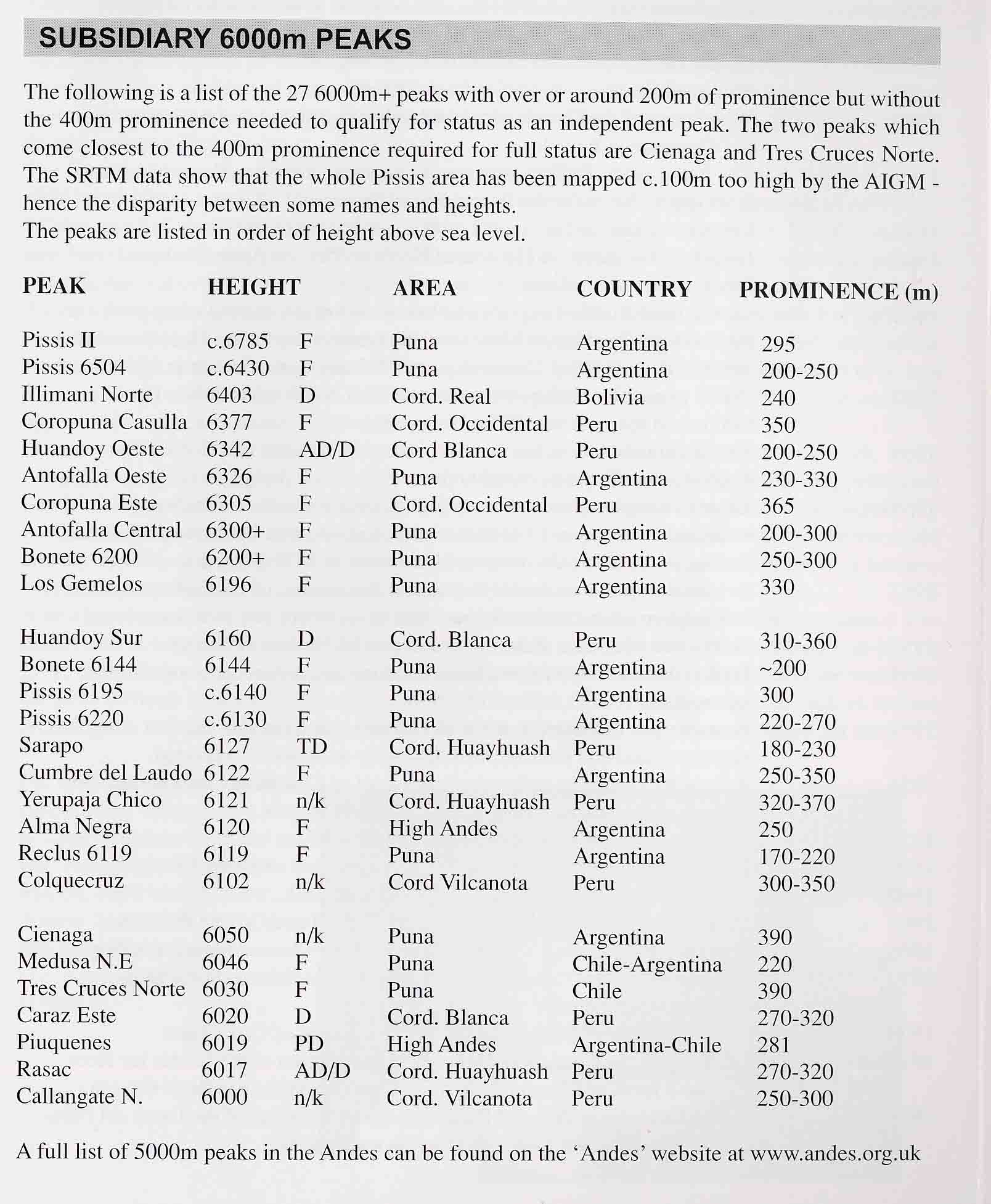
Map
Alpenverein's map of the Ojos del Salado area is good. There are some name mistakes and some routes marked on the map don't exist, but overall it's the best around.It also covers other peaks in the area, for example; Incahuasi, El Fraile, The Tres Cruces peaks, El Muerto and some others.
1:100 000
Recommended.
NOTE!
The Alpenverein map has one grave error!
The route marked to Agua Calientes and further to Agua Vicunas is in the wrong place. On the map it's placed way off to the north.