
|
|
Mountain/Rock |
|---|---|
|
|
46.42745°N / 13.45413°E |
|
|
Hiking, Mountaineering, Ice Climbing, Mixed, Scrambling, Skiing |
|
|
Spring, Summer, Fall, Winter |
|
|
7940 ft / 2420 m |
|
|
Overview
 Spik Hude Police, 2420m from the ferrata Leva.
Spik Hude Police / Cima di Terrarossa, 2420m is the one of the easiest approachable mountains in Vis and Montaz group. It is very high and has an amazing view from the summit. The mountain is located in the long crest of Iof di Montasio / Montaz, 2754m that comes from the NW side and continues in the SE direction over Spik nad Nosom / Foronon del Buinz, 2531m and Spik nad Spranjo / Modeon del Buinz, 2558m. Spik Hude Police rises up on the east side of the notch Skrbina nad Cijanerico / Forca del Palone, 2242m and then extends to Spik nad Tratico / Cime Gambon, 2392m on the east side.
 Spik Hude Police, 2420m (in the middle) from the notch Lavinal dell'Orso, 2138m.
The south slopes are steep and grassy, on some places also rocky and airy. Over this slopes goes the normal route. The normal approach is fine marked and easily you reach the summit over the wide path.
The north side is totally different. This the airy rocky face, high almost 1000 meters which falls down to the valley Zajezera / Valbruna. Here is located the highest couloir in the Julian Alps. It is called Canalone Huda Paliza and is high over 800 meters. It falls in straight line directly down to the slopes below the face where the bivouac Mazzeni, 1630m is located. The couloir is nice but hard Winter goal.
On the slopes of Cima di Terrarossa start two important and beautiful ferratas. One goes in west direction on Montaz / Iof di Montasio and is called Sent. attrezz. Leva (pot Leva). The description you can find here. The other one goes to the east side and it is called Sent. attrezz. Ceria Merlone. Both are amazing routes with fine view on whole Julian Alps. I think the Ceria Merlone is harder but also more beautiful because it goes almost all time over the ridges and shelters of Spik nad Nosom / Foronon del Buinz, 2531m and Spik nad Spranjo / Modeon del Buinz, 2558m. It starts from the normal approach to Spik Hude Police and ends in the notch Skrbina Prenje Spranje / Lavinal dell'Orso, 2138m.
 The view to Kanin group.
Spik Hude Police is located in the centre of the Vis and Montaz group so it has one of the most beautiful panoramas in this group.
Getting There
The approach valley to the Western Julian Alps will probably be the highway through Val Canale (Udine - Tarvisio). But of course it doesn't reach the heart of this mountain group.
The map of the area.
1. For the south ascent you must deter from the highway in Chiusaforte and travel through Rakolana (Reklanica, Raccolana) valley to Sella Nevea (Nevejsko sedlo) pass, 1142 m. This pass can also be reached from Tarvisio towards south through Valle Rio di Lago (Jezerska dolina). On Sella Nevea you turn towards north-west and drive by a narrow alpine road to Malga Pecol, 1520 m.
2. For the north ascent you deter from the highway some seven kilometers west of Tarvisio and drive south into the Valbruna (Zajzera) valley. The road ends on an alpine meadow on the altitude of 1000 m.
Tarvisio and Valle Rio di Lago (Jezerska dolina) can also be reached from east, from Slovenia (from the Sava valley or over the Predel (Predil) pass and of course also from north, from Austria (from Villach).
For some tourist information see the Tarvisio tourist page.
Maps:
- Tobacco Map 019 - 1:25000 - Alpi Giulie Occidentali Tarvisiano.
- Julijske Alpe - Zahodni del (Western part). Planinska zveza Slovenije. 1:50000.
Routes Overview
South approach. This is the normal approach from the south from the hut Rif. Brazza, 1660m. Easy marked route all to the summit.The description on the SP page.
The description in Italian language.
 The Canalone Huda Paliza.
There are some climbing routes in the N and NE faces but they are not very popular in snowless season.
The north face is very popular in Winter and Spring when there is a lot of snow. Between Spik Hude Police / Cima di Terrarossa, 2420m and Spik nad Tratico / Cime Gambon, 2392m is located the highest couloir in the Julian Alps, high around 800 meters called Ozebnik Huda Polica / Canalone Huda Paliza. It is not steeper more then 60° but in not good conditions has some rocky places. It was already skied. The difficulty is III with the passages S4.
There are also some nice routes for snow climbing. For example between the wildest towers in Vis and Montaz group, Torre Lazzara, 2263m and Torre Mazzeni, 2212m. For more details ask me.
Red Tape
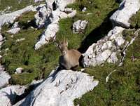 The alpine chamois.
No limitations or special permits.
When To Climb
The best and the easiest time is in the snowless season. That is in Summer and Autumn. But also in Winter there are some nice couloirs for climbing. But be careful because of avalanches and the loneliness of north face.Camping
Some huts and bivouacs.On south:
- Rif. Brazza, 1660 m (parking place just below it).
On north:
- Rif. Attillio Grego (parking place 400 m below it in Valbruna or on Sella di Somdogna, 1398m, 15 minutes away), 1395 m.
- Bivacco D. Mazzeni (bivouac), 1630m, just below the north wall.
Then a lot of camping places you can find in the valleys around Vis and Montaz group.