
-
 3915 Hits
-
 86.37% Score
-
 22 Votes
|
|
Mountain/Rock |
|---|---|
|
|
45.85700°N / 10.82210°E |
|
|
Trentino |
|
|
Hiking, Scrambling |
|
|
Spring, Summer, Fall, Winter |
|
|
2822 ft / 860 m |
|
|
Overview
Cima Nodice 860 m
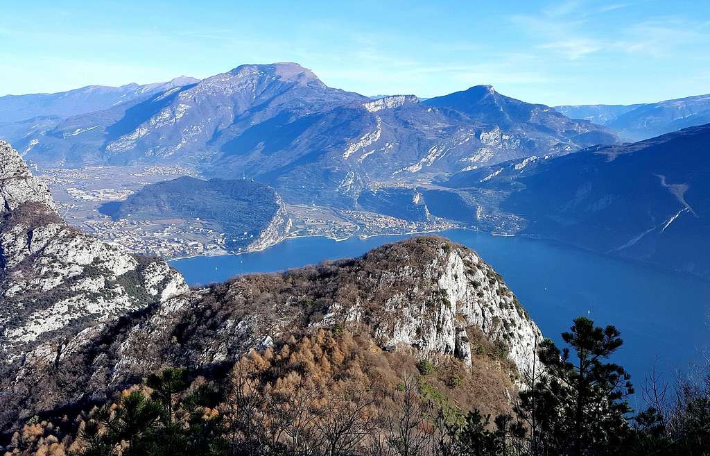
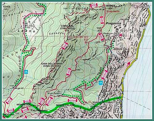
Cima Nodice 860 m is a minor summit belonging to Alpi di Ledro, a sector of the Prealpi Bresciane e Gardesane, and located nearby the border between Trentino and Lombardy counties. It closely overtops the Western shore of Lago di Garda with exceptional views. Cima Nodice is the first summit situated along the way to the so-called Pregasina Ridges and overlooks the Garda Lake and Val di Ledro with unforgettable views. On some topographic maps it is called Cima di Lè, but the name currently in use is Cima Nodice, taking origin from the name of the Austrian officer, Nodic, who directed the fortification works before the WWI. During the October 1915, the Italians after 5 days of attempts captured the top, still rich in remains of fortifications including walkways, galleries and observation stations on the underlying Lago di Garda.
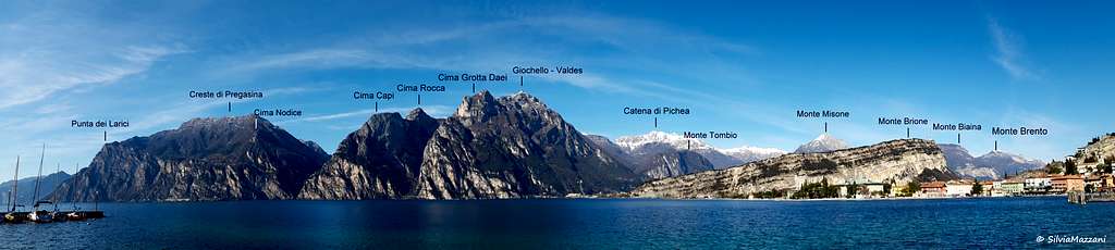
Cima Nodice is frequently climbed along the itinerary starting from the village of Pregasina, a hamlet of Riva del Garda, as first goal along the Pregasina Ridges. Another path starting from Biacesa joins the previous route at Bocca di Lè and from here climbs the summit.


The setting is pre-alpine and the route can be climbed all year round.
Getting There
Access: from the Brennero autoroute exit Rovereto Sud and take the road to Arco and Riva del Garda. From Riva del Garda follow the road to Val di Ledro, which is reached through two long tunnels. About 300 meters after the exit of the second tunnel, you find on the left the narrow but paved road leading to the village of Pregasina 532 m, a hamlet of Riva del Garda. Leave the car in the small parking lot below the church.


Route
Cima Nodice from Pregasina
Summit quote: 860 m
Difficulty: EE
Difference in level: 328 m from Pregasina
Starting point: Pregasina m 532
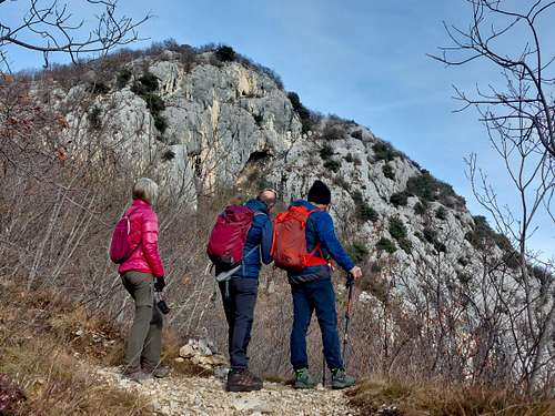
From the parking lot 522 m under the church of St. George in Pregasina take the narrow street rising to the church. From here we head to the left taking a signposted mule track, getting soon an obvious crossroad indicated by a signpost. We leave on the left the itinerary to Passo Larici and Passo Rocchetta and turn to the right on a steep and narrow concrete road. After a very steep first stretch we continue up a more moderate slope to another fork indicated by a signpost in locality Tof m 660.


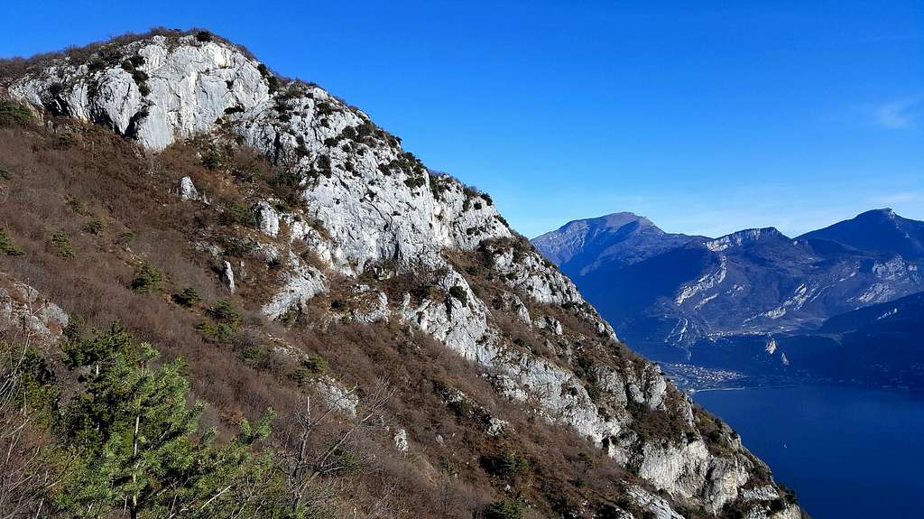
To the left it starts the path n. 422 towards Passo della Rocchetta, we maintain the right hand, following the path n. 429. When we get to a third fork, we leave on the left the path n. 429 to Bocca di Lè and turn right onto the path n. 429A, following the signpost to the Scala Santa and Cima Nodice. After a narrow rocky passage under a singular spire called "Popo de Lè", the trail passes close to the remains of some military constructions of the WWI.


Here it begins the beautiful section called "Scala Santa", a series of steps carved into the rock provided by an iron cable, that allows to overcome this rocky stretch by an easy walk. After the rocky steps we reach a point where it starts a good warpath well marked by red-white signs. This path entirely surrounds the summit of Cima Nodice and runs through trenches and caves carved into the rock.


Here at first we ignore this path to get the summit of Nodice in just two minutes, following a brief not well worn track leading to the remains of the summit Military Observatory.

We briefly return to the military ring surrounding the summit and we walk along it following the red-white marks, betting the path on the opposite side which descend getting the Cemetery of the Alpines and directly Bocca di Lè 806 m. From Bocca di Lè we take the left branch of the path, coming back to Pregasina.
Red Tape
No permits, no fees required.
Hiking Grades of difficulty
T - Turistico (Tourist): Itineraries on wide, clear and well worn paths, sometimes on mule tracks or gravel roads. The routes are never exposed, don't give any orientation problems and don't exceed 2500 meters of altitude. Suitable also for children.
E - Escursionisti (Hikers): Itineraries on marked trails, even narrow and with possible steep and impervious sections. They are never exposed and don't give any orientation problems. They can tread different kinds of ground, such as forests, gravel, meadows, pastures, easy rocks, etc.). They form the majority of the trails that wind up in the mountains and require a certain habit to walk; you need equipment suitable for the altitude and resistant footwear with soles suitable for rough terrain.
EE - Escursionisti Esperti (Experienced Hikers): Itineraries for hikers with experience and good knowledge of the mountain. Some of these paths may have exposed sections, however brief, which require firm foot and no dizziness. They require the ability to adapt to particular terrain, such as steep grassy slopes or stretches of rocks with difficulties that can reach the 1st degree of the UIAA scale. They can also reach high altitudes (3000 m or more). Sometimes they may include unmarked sections, requiring a good sense of orientation. Snow slopes are possible, however which can be overcome without specific mountaineering gear (rope, harness, crampons, ice-axe).
EEA - Escursionisti Esperti con Attrezzatura (Experienced Hikers with equipment - The same as EE, in addition these routes require the use of via ferrata equipment (lanyards, harness, carabiners, heat sink, helmet). This kind of itineraries range from the trails with short easy and not much exposed sections, previously equipped with fixed ropes and iron pegs, to the true and more difficult Via Ferratas climbing on rocky walls or on aerial ridges and ledges, previously equipped with long stretches of iron ropes, iron steps, ladders without which proceeding would constitute a real climbing. It is necessary to know how to use the technical equipment and have a certain habit of exposure and mountaineering terrains.
When to Climb


Best seasons are Spring, Autumn and Winter. Summer months may be very hot.
Accomodation
Different possibilities of accomodation in Riva del Garda, Val di Ledro and Pregasina
Guidebooks and maps
"Prealpi Bresciane" by Fausto Camerini - Collana Guide dei Monti d'Italia, CAI-TCI
Maps:
KOMPASS sheeet 071 – Alpi di Ledro Valli Giudicarie 1:50.000
LAGIRALPINA sheet 016 - Alpi di Ledro - Tremalzo 1:25.000
Meteo
Meteo Trentino
Meteo Arpa Lombardia