
|
|
Mountain/Rock |
|---|---|
|
|
43.81470°N / 114.2053°W |
|
|
10516 ft / 3205 m |
|
|
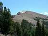
Phi Kappa
Phi Kappa Mountain's beautiful north face holds snow well into the summer months.

Phi Kappa is located along the far-most northwestern portion of the grand Pioneer Mountains in central Idaho. It is easily seen from the Ketchum/Sun Valley Area and is quite impressive when viewed along Trail Creek Road in the upper reaches of the Big Lost River Valley.
Compared to surrounding Pioneer peaks, the terrain of Phi Kappa is mellow. The most commonly utilized route climbs the gentle eastern slopes, while more of climb and scramble awaits hikers on the more impressive north face.
Phi Kappa is not a commonly hiked mountain. Many hikers from the region travel to the area to ascend higher and more challenging peaks nearby, such as the The Devils Bedstead East, Goat Mountain, and Hyndman Peak. However, because of its proximity to Sun Valley and Trail Creek Road, as well its gently slopes, Phi Kappa is a popular back country ski area for locals.
 |  |  |  |  |
Summit Creek Peak
Summit Creek Peak is Phi Kappa's, slighly higher, twin summit. Not officially named on any USGS quad, this mountain is hardly known by anyone and often overlooked by hikers and scramblers.

Summit Creek Peak's terrain is similar to that of Phi Kappa's. Its eastern slopes are mostly broad and gentle, dotted with trees. While the eastern face plummets quickly down into the headwaters of Phi Kappa Creek.
A climb to the summit is almost always followed by first hiking Phi Kappa, the ridge between the two offers spectacular views and is non technical.
 |
Getting There
The more common route up these mountains it to hike up the Summit Creek route, it is less technical yet has a much longer approach.
I took a more direct approach to the summits.
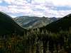
From Sun Valley drve northeast on Trail Creek Road. After 12 miles you will reach Trail Creek Summit. Continue heading on this road until you see the Phi Kappa Campground on your right. Shortly after the you see the campground, you will cross a cattle guard and a little dirt road veers of to the right. Take this rough dirt road which splits a few times, my memory is a bit rusty but im sure if you stay left you will be fine.
Once you have made it across the valley and start heading into the woods, the road forks again. The right fork looks like the correct way but take the left which climbs steeply out of the valley. Continue on this road until two swtichbacks lead you to an old mine. Park here unless you are crazy and wish to keep driving on the road.
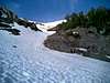
Hike up the faint jeep trail one and a half to two miles until you enter a beautiful basin with Phi Kappa rising dramatically in front of you and its twin to your right. From here head southeast to the saddle between Phi Kappa and Pt. 10,178.
Once at the 9,800' contour line a small gull will lead south. Take this gully and scramble up to the northeast ridge of Phi Kappa, its easiest on this scramble to stay on the vegetation line. Once on the northeast ridge, continue heading toward the summit where some class three climbing will await you.
Once on the summit, take in the beautiful views of the surrounding area before heading to Summit Creek Peak.
To climb the twin summit of Summit Creek Peak, continue on the connecting ridgeline northwesterward. Dropping no more than 400 feet, the view from the summit allows you to look over your entire hike so far.
From the summit, it is easy to drop down the face of the peak into the basin below, or if you wish, return the same way you came.
 |  |
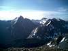
Summit Views
Various views taken from both summits.
 |  |  |
Red Tape
No permits required or user fees needed. Trail Creek Pass stays open until snow closes it out, while in the spring it opens a a little earlier than most other roads in the area due to the help of local snow plow men.
When To Climb
For beginner to intermediate hikers who wish for a nice easy hike not to far from town normal summer months apply for when a good time to scramble this mountain. As for back country skiiers, early to mid spring is the most common time to ski Phi Kappa, the reason being its ominous north face holds snow much longer than the surrounding valleys and roads.
Camping
If you feel the need to make this a two day trip, Phi Kappa campground right off Trail Creek Road provides plenty of space for camping.
Mountain Conditions
These summits are located in very remote areas, refer to local weather reports for conditions.