|
|
Mountain/Rock |
|---|---|
|
|
43.75320°N / 114.087°W |
|
|
11000 ft / 3353 m |
|
|
Overview

Mustang Peak is quite impressive, though relatively unheard of, and well deserving of receiving some recognition. The mountain is a series of small peaks, all above 10,800' along a ridgeline that deviates impressively from the main crust of the Pioneers. The highest elevation is found on the the second northern most point along the ridgeline standing at more than 11,000'.
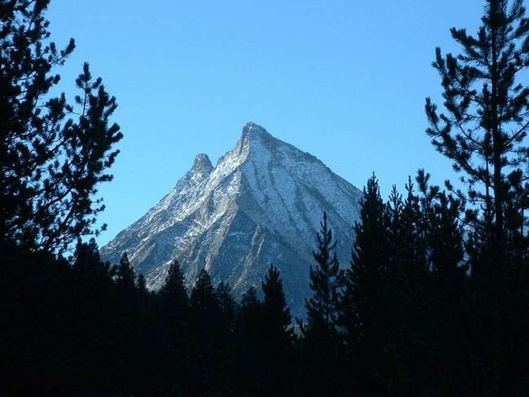
Mustang Peak forms an incredible backdrop to Wildhorse Canyon with its large, bright white north face that rises dramatically from the valley below. Its location in the center of a large loop the main Pioneer Crest creates, makes for views from the summit that incomparable to any other peak.
Mustang Peak is rarely climbed for many reasons. It is not officially named and just barely meets the 300' of prominence rule to be considered a bona fide mountain. There is no rock cairn at the summit, let alone summit register, and at minimum requires difficult class 3 climb to reach the summit.
The unofficial name Mustang Peak comes from an unknown motivation by Ketchum locals. The secondary title, Howard Peak, is named for Mike Howard of south central Idaho, a very accomplished climber in the state.
Getting There
Requirements For Accessing TrailheadGetting to Howard Peak is an adventure in itself and makes the climb even more rewarding.
From Sun Valley Idaho, drive northeast on Trail Creek Road up and over the Trail Creek Summit. Continue down into the next valley over until reaching the turnoff for Copper Basin that is clearly marked.
Travel on the Copper Basin Road, which is a an improved dirt road, until coming to the turnoff for Wildhorse Canyon, in about 3 miles. Follow the good dirt road 6 miles until coming to the large Wildhorse Campground.
The road in the campground forms a large one way, clockwise circle. At the apex of a circle, look for a faint road that continues up the canyon. There is a sign that is difficult to spot that says, Caution Narrow Rough Road.
Unless you have flawless dirt road driving, and a very high clearance vehicle, stop here and either hike or bicycle up the road.
Otherwise, begin the long and treacherous drive up one of the roughest roads in the state. Watch out for large boulders, road erosion, log crossings, and deep puddles. Allow 2 and 1/2 to 3 hours if planning on driving to the trailhead.
About 1 and 1/2 miles past the old mine, a small rock cairn will mark where the trail leaves the main road and continues along the main fork of Wildhorse Creek. If the road begins switchbacking to the east up a hill, you've gone to far.
Wildhorse Cirque Route
Requirements for climbing Howard Peak's Wildhorse Cirque RouteFrom the trailhead, cross the Left Fork Wildhorse Creek on two sturdy logs supported by ropes into the forests below Howard Peak. Hike this trail high into the cirque that feels more along the lines of Shanga La then central Idaho to the 9,000' contour line.
Here, in the midst of a large and rare Whitebark Pine Tree forest, turn east to northeast and follow the mellow terrain aiming for the north side of Howard Peak. Once you have broken out of the forest at 9,600', you will have your first clear view of the mountain.
Two distinct peaks can be seen from this point and although it may seem the spire to the right is the summit, Howard Peak is on the left. Climb toward the saddle between the two.

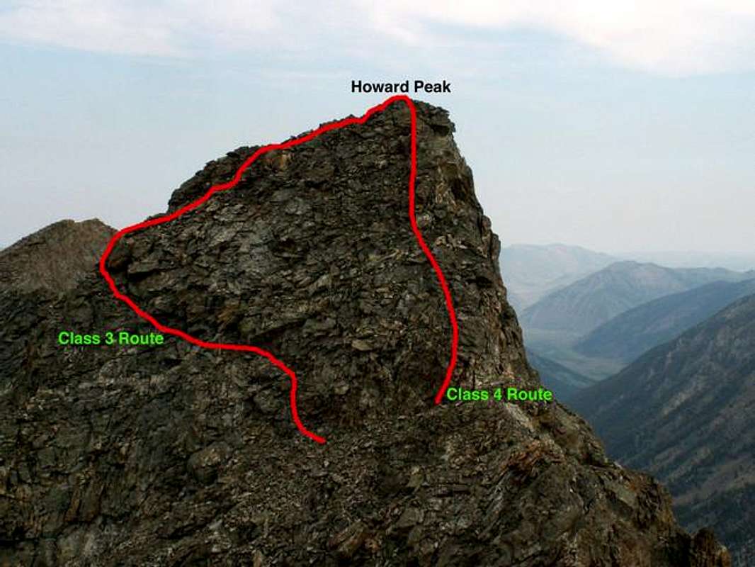
Climbing due east, gain the first ledge above a set of cliffs via a small gully system and easy class 3 terrain. Continue heading east through boulder fields until reaching the gully below the saddle between Howard Peak and the slightly lower summit to the south.
From the saddle, you may head directly up the ridge to the summit. However, this route involves class 4 terrain and quite a bit of exposure.
Otherwise, drop below the main ridge and a set of cliffs about 10-15' high. Continue traversing along a small ledge below the cliffs until reaching a drop off to the west. At this point find some hand holds up little ravines in the cliffs to the gain the boulder field above.
Once you have reached the steeo boulder field, it is just a few more feet to the summit and incredible views.
Other Howard Peak Summits
Howard Peak's summit ridge has many worthy climbs beside the summit itself. They range from relatively smooth and rounded to difficult and craggy. The true summit may be the most difficult of them all.Three of the spires are worthy goals and do not require technical climbing to summit them. The only one with an officially measured elevation by the USGS, Peak 10,825 does in fact require ropes though no details on the ascent are available.
Here is a quick explanation of the three other summits worthy of taking a look at while in the area starting from north to south. The route explanation begins at the 9,600' contour line at the end of the Whitebark Pine forest.
Summit 1
Access
From the Whitebark Pine Forest, turn directly north and climb toward the distinct rib that runs northeast to the summit. Once on the ridge, it is an easy, yet lengthy ridge walk to the summit. A traverse to the true summit would require class 5 climbing.
Summit 2
Access
From the 9,600' contour line above the Whitebark Pine forest climb to the saddle between the Summit 2 and Howard Peak. At the saddle, a notch in the center of the summit block comes into view. Traverse across the face to the base of the notch and climb up moderately difficult class 3 terrain to the top.
Summit 3
Access
Instead of leaving the trail and hiking through the Whitebark Pine forest, continue on the trail until reaching a point below the cliffs that lead to Arrowhead Lake. Climb through the small sets of cliffs to gain Summit 3's sharp west ridge. Climb the ridge by occasionally dropping to the south side to avoid some towers that block the route.
Red Tape
This area is closed to winter snow-machines and ATV vehicles past the trailhead area.Enough emphasis cannot be put on being experienced in off roading conditions for this area. If you uhave any doubt about driving abilities, bike in!
Please distance yourself from any mountain goats in the area.
River crossings in this area are nearly impossible year-round because of the amount of precipitation recieved annually.
When To Climb
The exposure of the route and rugged location allow snowfields to remain year-round in the area. Therefore, the climbing season is restricted to early-August through late-September.A winter ascent would be close to impossible when taking in consideration of the steep terrain and complete isolation.
Camping
There are several options for for camping in the area.The recommended spot would be the sprawling Wildhorse Campground about 6 miles north of the peak.
There are also several small pullout areas along the the Wildhorse Road past the campground as well as ample space for tent camping below the peak in the higher areas of the cirque.


