
-
 26218 Hits
-
 92.28% Score
-
 38 Votes
|
|
Mountain/Rock |
|---|---|
|
|
43.78460°N / 114.0242°W |
|
|
Custer |
|
|
Hiking, Scrambling |
|
|
Summer, Fall |
|
|
11878 ft / 3620 m |
|
|
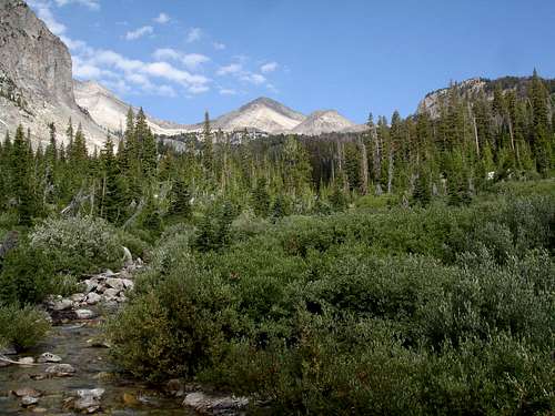 Standhope from Broad Canyon
Overview
Standhope Peak is a classic pyramid shaped peak located in central Idaho’s Pioneer Mountains. The Pioneers are one of the states premier mountain ranges and are home to scores of soaring summits, high alpine lakes, and wildflower filled meadows. A climb of Standhope Peak will allow you to experience all of these outstanding features. Standhope soars high above Betty Lake and Goat Lake as well as Surprise Valley and is the dominant feature in the surrounding area despite the fact that it’s only the second tallest peak in the vicinity. (Nearby Peak 11887’ stands a mere 9 feet taller). Standhope dominates because of its pyramidal shape and a centralized location relative to the hiking trails in the area. At 11878’ in elevation, Standhope is ranked at number 20 amongst Idaho’s Highest Peaks and is actually the seventh highest officially named peak in Idaho. USGS surveyor Thomas M. Bannon first climbed Standhope sometime prior to 1917. Bannon recorded numerous first ascents in Idaho, including Mount Borah.Standhope lies in a remote section of the Pioneers typically accessed via Copper Basin, a uniquely beautiful high desert valley. Despite this remoteness, the alpine lakes just east and south of Standhope Peak are among the most popular backpacking destinations in the Pioneers. Betty Lake to the east of Standhope is a beautiful turquoise gem where you can catch trout with a little perseverance. Probably more noteworthy is 10438’ Goat Lake. It lies just south of Standhope Peak and is considered the highest elevation lake in Idaho based on the most current USGS quadrangle maps.
Despite the relative popularity of the area, Standhope Peak is not summitted frequently. This is probably due to the fact that many hikers and backpackers who enter the area chose not to climb Standhope because all routes are Class 3 difficulty or greater. That being said, anyone who is at all comfortable scrambling should have no problem reaching the summit. Exposure can be avoided on most routes and the rock is generally stable, but likely too shattered for technical climbing. One can reach Standhope in a long day, but backpacking in is recommended in order to allow time to take in the beauty of the area. Sticking around a little longer may also allow for time to climb other nearby 11ers Altair Peak and Peak 11887’.
Views from the Summit
Those who venture to the summit of Standhope Peak are rewarded with fantastic views in all directions. Probably the most impressive view is to the southwest where much of the main Pioneer crest is visible including Hyndman Peak, Old Hyndman, and Cobb Peaks. Also visible directly to the west is the hulking Devil’s Bedstead East. To the northwest lies the hard to reach Angel Lake and other unnamed lakes with outlets streams tumbling into the Fall Creek drainage. Surprise Valley is visible just north of Standhope and is home to a Research Natural Area. Farther east, many peaks can be seen including Pegasus Peak, Big Black Dome, and the pale Altair Peak. Continuing on in a clockwise rotation are Betty Lake to the east and Goat Lake to the South. Just beyond Goat Lake is the lovely Baptie Lake, with Broad Canyon stretching out in the distance. Finally, located immediately to the southwest of Stanhope is fin-like and slightly taller Peak 11887’, the nineteenth highest mountain in Idaho. |
 |
 |
 |
 |
Getting There
 Goat Lake
Driving directions to access the trailhead for southern approaches from the Broad Canyon “Recreation Site” are as follows. From downtown Ketchum Idaho, follow Trail Creek Road through Sun Valley, over Trail Creek Summit, to the signed turnoff for Copper Basin and Wildhorse Canyon. The turnoff is about 22 miles northeast from Ketchum, or about 19 miles southwest from US-93 if coming from Challis or Mackay. Once at the turnoff, go right (east) and follow the road for about 12 miles then turn right again (south) on Copper Basin Loop Road. Continue for another 8 miles to the marked fork for Broad Canyon. Follow this road for another half mile to the trailhead, home to several picnic tables and an outhouse.
For an approach from the north via Surprise Valley, follow Trail Creek Road to the Copper Basin and Wildhorse Canyon turnoff and follow the road for about 6 miles to the turnoff for Wildhorse Canyon. Turn right here and follow the road for about 3.5 miles then turn left and continue another half mile to the Fall Creek trailhead.
All four of Standhope’s ridgelines are at or near a Class 3 difficulty rating. The southeast ridge from the saddle between Betty Lake and Goat Lake is the most commonly used route. The least technically challenging option is the Southwest Ridge via Goat Lake, but it requires more effort because of the amount of loose rock to contend with on the way to the saddle between Standhope and Peak 11887’.
Camping
 Betty Lake
Camping opportunities are plentiful in the area around Standhope Peak. Options include the lakes in Surprise Valley if approaching from the north, or Betty and Goat Lakes if coming from the south. Betty Lake and Goat Lake are both above tree line and therefore a bit exposed, but there are other smaller lakes down lower as well as several good campsites at various points along the trail.
If you prefer to go lighter and make camp near your vehicle instead, there are campsites at the Broad Canyon trailhead to the south, or at Wildhorse Campground near the northern trailhead.
Red Tape
No red tape to speak of, just tread lightly.When to Climb
The Pioneers receive quite a bit of snow, so the summer climbing season starts a bit later than the rest of the state. A snow free climb can be done most years from late July until the snow flies in late September or early October. This can vary of course. There are no winter ascents recorded for Standhope Peak, but Lopez points out that the north face has good potential for a spring snow climb.Mountain Conditions
- Lost River Ranger District - Contact Information for the responsible Forest Service Office.
- NOAA Pinpoint Forecast – Weather.
- Idaho Outdoors Forum – Message board monitored by many local climbers.
Guidebooks
There are a few guidebooks with good information available for the Pioneers and the area surrounding Standhope Peak. Here are a couple of the best ones.- Idaho: A Climbing Guide by Tom Lopez – This is far and away the premier mountaineering text for the state, with an entire section devoted to the Pioneers including detailed route information for Standhope Peak.

- Trails of Western Idaho by Margaret Fuller – Includes detailed approach information for both Surprise Valley and Betty Lake.
