Bob Marshall Country

Page Type Page Type: Area/Range
Location Lat/Lon: 47.81300°N / 112.799°W
Activities Activities: Hiking, Mountaineering, Scrambling
Seasons Season: Summer
Additional Information Elevation: 9411 ft / 2868 m
Sign the Climber's Log

Overview

Rocky Mountain Front from Mount Wright

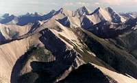
A mountaintop view of some real wilderness, Rocky Mountain Front

“Those who have packed far up into grizzly country know that the presence of even one grizzly on the land elevates the mountains, deepens the canyons, chills the winds, brightens the stars, darkens the forest, and quickens the pulse of all who enter it. They know that when a bear dies, something sacred in every living thing interconnected with that realm…also dies.” --John Murray

“Only the mountain has lived long enough to listen objectively to the howl of the wolf.” --Aldo Leopold

If you look at a map of Montana, you will see a vast roadless area stretching south from Glacier National Park and U.S. 2 almost to Rogers Pass, and it's plenty wide, too. This is the Bob Marshall Wilderness Complex, or "The Bob," and it consists of three contiguous wilderness areas. They are, from north to south, the Great Bear, the Bob Marshall, and the Scapegoat. The scenery out there is unbelievable, and the area contains what some people think might be the most dramatic natural feature of the Rockies: the Chinese Wall, a limestone escarpment deep in the wilderness and a part of the Continental Divide.

Everyone has his or her own idea of what wilderness is, and everyone has his or her own expectations of it. Legally speaking, wilderness is land "forever" protected as roadless and from further human development by the government, but wilderness, to those who love and seek it, is more spiritual than technical in meaning. Take Colorado, for instance. The scenery is spectacular and generally easy to reach because trails tend to start high and climb steeply, avoiding the long approaches so often necessary to access the best of the Northern Rockies. But Colorado, awesome as it is and inspirational as it has been to me over and over again, lacks much real wilderness, the way I define it, at least. With some important exceptions, designated wilderness areas there are small, and all of them see heavy human usage and bear plenty of scars from it. And it's very difficult in Colorado to find a good summit whose views don't include at least some signs of human development.

Rocky Mountain

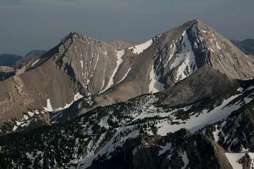
Rocky Mountain, Sawtooth Range (and highpoint of the Bob Marshall Wilderness)

To me, real mountain wilderness has to be deep, vast, and soaked in at least the feeling that few or no other people have ever been where you are. And it has to be big enough, rugged enough, and wild enough to be home to grizzly bears and wolves, which are the living symbols of American wilderness. For those reasons, I think there are only three real mountain wildernesses in the U.S. outside Alaska-- the Greater Yellowstone Ecosystem, Glacier National Park, and Bob Marshall country. The Cabinet Mountains and, even more so, the North Cascades, the Mission Range, and (get a lot of air first if you're reading this aloud) the Selway-Bitterroot/Frank Church-River of No Return complex are also strong contenders. To feel as though you are really away from civilization and in touch with all that is wild, head deep into one of these areas, going with the simultaneous hope and fear of encountering the Great Bear, and make yourself a part of the heart of the wild world. Out there you can feel close to something primordial, primitive, and eternal-- a world of raw nature and sharp instinct. Another plus my three areas of honor have going for them is that the mighty Continental Divide runs through them. There is something about the Great Divide that draws me to it and compels me to stand atop its peaks, passes, and ridges and to camp in its shadow. The Glacier-Bob Marshall-Yellowstone corridor offers ample opportunities to do all of those things. 
Great Northern Mountain-- Summit

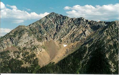
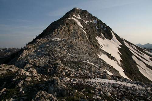
Great Northern Mountain, Flathead Range

Several named ranges comprise the Bob Marshall Wilderness Complex. The best-known, probably because of their visibility from paved roads, are the Flathead Range in the north, the Swan Range in the west, and the Rocky Mountain Front in the east. Other (and smaller) named ranges such as the Trilobite Range, the Sawtooth Range (really a part of the Rocky Mountain Front), and the Lewis and Clark Range are equally impressive at the very least, but those three really define the area and are the gateways to its vast interior. And although places like Jewel Basin and Our Lake aren't technically within the wilderness boundaries, there is no denying that they belong to this area and possess its wilderness character.
Carmine Peak

Carmine Peak, Swan Range

The Flatheads and Swans aren't easy to appreciate from the road, but you can get decent views occasionally from U.S. 2 between East Glacier and West Glacier, and from MT 83 through the Swan Valley. The Rocky Mountain Front is easy to see and admire from the road because, unlike in the other areas, the paved roads nearby run through the western edge of the Great Plains and offer unobstructed views of the mountains. U.S. 89 between Choteau and Browning offers particularly good scenery.
Freezeout Lake and the Rocky Mountain Front

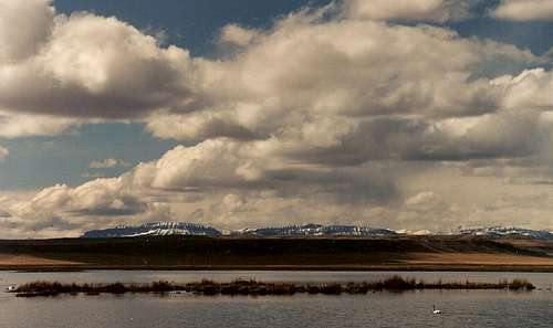
Rocky Mountain Front from Freezeout Lake

The Bob is a backpacker or horsepacker's dream, but it is possible to enjoy it via day hikes. The Sawtooth Range in the Front is an excellent place for this, as are Jewel Basin and the Holland Lake area on the west side and Marion and Stanton Lakes on the north side. Climbers can find gobs of solitude and can follow Class 1 trails to summits or make their own Class 2-5 routes up spectacular peaks named and unnamed.
Teton Peak-- Summit Ridge

Teton Peak, Sawtooth Range (part of the Rocky Mountain Front)
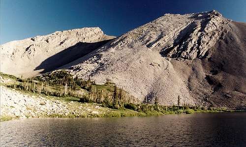
To learn more about this special area's possibilities far beyond what this page can give you, I strongly recommend Hiking Montana's Bob Marshall Wilderness, which gives a lifetime's worth of details about day trips, extended trips, and driving directions to the numerous major trailheads. Hiking Montana also has a good amount of information about the area, and its scope is friendlier to day hikers while having the bonus of covering the rest of Montana. Both books are from Falcon Publishing.
Point 8466 and Our Lake

Our Lake

To get a taste of the Bob without hiking long distances or committing to any climbs first, try Jewel Basin (Swan Range) on the west side near Bigfork, and Our Lake and Mount Wright, both on the east side near Choteau. As I said already, Jewel Basin and Our Lake aren't officially in the wilderness areas, and Mount Wright is only on the border of the Bob Marshall, but these places have all the flavor and excitement of the larger complex. They are enough to satisfy you and make you feel as though you have gotten a feel of the region, but they more likely will awaken a craving for more.
Chinese Wall

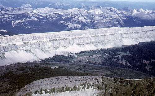
The Chinese Wall-- by Fred Spicker

Getting There

The busiest access points are at Holland Lake on the west side, between Condon and Seeley Lake, and Benchmark on the east side, near Augusta. The guidebooks I recommend have excellent driving directions to these and other sites. I like the east side the most because it is drier and thus has less forest cover, and for that reason I recommend using Choteau as a base if you're day hiking. It will still take you up to an hour to get to the trailheads, but you should be leaving nice and early, anyway. Choteau has a good selection of motels, restaurants, and other services. There are limited services elsewhere until you get close to Glacier National Park. If you can afford it ($1500 per person per week in 2007), try the Nature Conservancy's Pine Butte Guest Ranch west of Choteau and in the mountains. It's nice and secluded, and they provide all meals. Campgrounds abound all over the place. In Essex on the north side, there is the Izaak Walton Inn, a neat place to stay, especially if you're into railroads.
Cliffs above the South Fork Teton River

Driving to the Our Lake trailhead in the Sawtooth Range, you'll pass these cliffs.

Red Tape

I don't know of any as of now. There is sometimes talk of permit systems at some of the busier areas, but that remains just talk as far as I know. If in doubt, contact one of the four national forests that share this area: Flathead, Helena, Lewis and Clark, and Lolo.

Camping

The place is thick with campgrounds. Dispersed camping is possible in many places.