
-
 8112 Hits
-
 89.01% Score
-
 28 Votes
|
|
Mountain/Rock |
|---|---|
|
|
45.87200°N / 7.09228°E |
|
|
Mountaineering |
|
|
9377 ft / 2858 m |
|
|
Overview
Small and smart pyramide rising at the end of the long NNW border ridge of Grand Golliaz. Seldom climbed, is a good panoramic spot on the eastern side of Mont Blanc Group. Hardly distiguishable from italian side it is very evident from the swiss one.
Piccola ed elegante piramide che si eleva al termine della lunga cresta N-NW del Grand Golliaz, di confine, raramente salita, e buon punto panoramico sul settore orientale della Catena del Monte Bianco. Appena visibile sul lato italiano, mentre si staglia più evidente sullo svizzero.

First Ascents
- First on the summit: Maurice Chapuis and Marcel Kurz, (Jul 22th, 1904).
- NE Wall (from Colle des Angroniettes): Alessandro Cardellina and Osvaldo Cardellina, (Aug 06th, 1996).
- In winter: Unknown.
At the foot of Aiguilles des Angroniettes (2.858m) coming from Col Ban Darrey
Getting There
BY CAR:- From Torino, Milano, etc: Motorway A5. Exit at Morgex.
- From Switzerland: through the Grand St. Bernard Tunnel or the homonym pass.
- From France: through Mont Blanc Tunnel or Petit St. Bernard Pass.
- Aeroporto "Corrado Gex" Saint Christophe (Aosta).
Moving the cursor one can see the overall scene
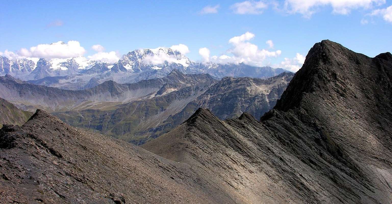
From left: Mont Vèlan (3.734m), Aiguilles des Angroniettes (2.858m), Grande Rochère (3.326m) and Les Grandes Jorasses (4.208m)
|

Approach
From A5 Morgex toll drive along the SS.26 toward Courmayeur, cross it and once in Entréves follow for the Val Ferret. Till the end of the road (Arnouva - 1.769m) - car parking.Dall'uscita dell'Autostrada A5 nel comune di Morgex (921 m) proseguire lungo la SS.26, verso il Paese di Courmayeur (1.228 m) e, raggiunta la Frazione di Entrèves (1.326 m), continuare verso N lungo la Val Ferret. Oltrepassate le Frazioni di: la Palud (1.370 m), Plampincieux (1.593 m) e la Vachey (1.642 m) si raggiunge l'Alpeggio di Arnouva (1.769 m palina di divieto di transito alle auto), dove inizia l'itinerario a piedi.
Route
From Arnouva (1.769m) follow along the road (open only to the cars of the ones that have a booking at Rifugio Elena) and along the path n° 25 get the Prè de Bar Pasture (2.062m - 1h'30). Along the path up to Tramail (2.264m) and the following fork (2.316m). Leave, on the left, the path to Col Ferret and follow toward East a narrow path pointing to the stream; in the bottom of the small valley the path becomes a simple and not always marked track. Along the stream on debris the climb a short rocky bar just under the wide saddle of the ridge (Col du Ban Darrey; 2.696m). From here, along the easy NNE ridge, in about half an hour, to the summit (4h'00/4h'30). Descent: Retracing the route.Da Arnouva (1.769 m) proseguire per breve tratto sulla strada, chiusa al traffico, sino al bivio (1.793 m), dove parte il sentiero n° 25 per il Rifugio Elena ed il Colle del Gran Ferret. Risalire alla Tsa de Djuan (1.933 m) e continuando verso N, con alcuni saliscendi, percorrere alla base tutto il Vallone de la Belle Combe per entrare in quello di Combette arrivando al Rifugio Elena, ristrutturato, presso l'Alpe Prè de Bar (2.062 m; 1h'30). Continuare sull'ottimo sentiero e risalire al Tramail (2.264 m) e al successivo bivio (2.316 m). Abbandonato a sinistra (N) il sentiero n° 25 per il Colle del Gran Ferret, proseguire verso E su sentiero più malagevole, che gradualmente va avvicinandosi al torrente verso SE; lo stesso, sul fondo del vallone diviene una traccia, non sempre evidente. Proseguire lungo il torrentello su detriti e superare una piccola fascia di rocce appena sotto l'ampia sella del Col du Ban Darrey (2.696 m). Da questo risalire la facile cresta di frontiera N-NE, che in circa 0h'30 conduce alla vetta (4h'00/4h'30). Discesa: Lungo la via di salita.
Difficulty
For experienced hikers E/F.L'itinerario è considerato da E/F.
Huts
- Rifugio Elena (2.061m) Tel.: (+39) 0165844688 (Refuge - Rifugio) (+39) 0165861127 (House - Abitazione) (+39) 0165862503 (Fax) e-Mail: rifugioelena@virgilio.it
Gear
Hiking gear.Da escursionismo.
MAPS:
Campings
Remember that free camping is forbidden (except for emergency reasons, over 2.500m, from darkness until dawn).Mountain Conditions
- You can get meteo information at the official site of the Regione Valle d'Aosta:
- Valle d'Aosta Meteo
Webcam
- WEBCAM on Aosta Valley:
- Webcam
Books and Maps
BOOKS:- "Guida delle Alpi Occidentali", di Giovanni Bobba e Luigi Vaccarone C.A.I. Sezione di Torino Volume II (parte II), 25 Maggio 1896.
- "Guida dei Monti d'Italia-Alpi Pennine" (Vol.I°) di Gino Buscaini-Club Alpino Italiano/Turing Club Italiano, Luglio 1971 (in Italian).
- "Guida della Regione Autonoma Valle d'Aosta" di Mario Aldrovandi; Ed. S.P.E. di Carlo Fanton, Torino 1964.
- "I Rifugi della Valle d'Aosta" di Stefano Ardito, Ed. Guide iter, Febbraio 2003.
- "A piedi in Valle d'Aosta" (Vol.1), di Stefano Ardito, Ed. Guide iter, Giugno 2003.
- "Diari Alpinistici" di Osvaldo Cardellina e Indice Generale accompagnato da Schedario Relazioni Ascensioni 1964-2019 (inediti).
 |
 |
 |
 |
- Kompass "Massiccio del Monte Bianco Valle d'Aosta Sentieri e Rifugi" Carta turistica 1:50.000.
- I.G.C. Istituto Geografico Centrale Torino "Massiccio del Monte Bianco" (n° 4), Torino, 1998 1:50.000.
- I.G.C. Istituto Geografico Centrale Torino "Monte Bianco-Courmayeur-Chamonix-La Thuile" (n° 107), 1:25.000.
- L’Escursionista "Monte Bianco Courmayeur" (n° 1) Edizioni Rimini 2004 1:25.000.
- L'Escursionista "Gran San Bernardo Ollomont" Ed. Rimini ( n° 5) 1: 25.000.
- Edizioni Tabacco "Mont Blanc" Udine, 1978 1:50.000.
- Studio F.M.B. Bologna 1988 "Monte Bianco-Mont Blanc" 1:50.000.
Important Information
- REGIONE AUTONOMA VALLE D'AOSTA the official site.
- FONDAZIONE MONTAGNA SICURA Villa Cameron, località Villard de la Palud n° 1 Courmayeur (AO) Tel: 39 0165 897602 - Fax: 39 0165 897647.
- Società Guide Alpine Courmayeur www.Guidecourmayeur.com - Strada Villair n° 2 - 11013 Courmayeur (Aosta) Italy - Tel. +390165842064 Fax. +390165842357 - P.I. 01022640070
- A.I.NE.VA. (Associazione Interregionale Neve e Valanghe).
Useful numbers
- Protezione Civile Valdostana località Aeroporto n° 7/A Saint Christophe (Ao) Tel. 0165-238222.
- Bollettino Meteo (weather info) Tel. 0165-44113.
- Unità Operativa di Soccorso Sanitario Tel. 118.