Overview
![Kleiner Beil]() Kleiner Beil (center with Großer Beil to the left) as seen from Lämpersberg ascent
Kleiner Beil (center with Großer Beil to the left) as seen from Lämpersberg ascent
Kleiner Beil, the little brother of
Großer Beil sits on the connecting ridge
Lämpersberg – Großer Beil, which offers a nice traverse of these summits; this is, in my opinion, the main reason of visiting Kleiner Beil.
Kleiner Beil is a long rock and meadow ridge, the northern end, which drops about 100 m down to a notch between Lämpersberg and our summit, bearing the summit cross, the southern end is called sometimes
Seekopf, in my opinion not a summit of its own: it is only 30 m higher than the connecting notch to Großer Beil.
Two other route opportunities can be recommended:
The
east ridge from the summit to Seefeldalm is an easy, unmarked footpath with some scrambling and a nice alternative if you come from Lämpersberg and don´t want to do the whole traverse to Großer Beil to return to Schönangeralm.
The only ski route to Kleiner Beil from Inneralpbach via Stadelkehralm is for sure one of the more lonely ski routes within Kitzbüheler Alps.
Getting There
Main trailheads for Kleiner Beil are:
by car
The general accesses to the valleys are described on the
Kitzbüheler Alpen main page.
![Kleiner Beil]() Kleiner Beil and Großer Beil behind as seen from Lämpersberg summit Kleiner Beil and Großer Beil behind as seen from Lämpersberg summit | ![Kleiner Beil]() Kleiner Beil and, behind, Lämpersberg as seen from Großer Beil Kleiner Beil and, behind, Lämpersberg as seen from Großer Beil |
Please note that the frequency of these busses per day is not very high (about once every hour).
Routes Overview
Routes Overview Lämpersberg and
Kleiner Beil
![Kleiner Beil]() On the trail down to Schönanger Alm with Feldalphorn and Schwaiberghorn On the trail down to Schönanger Alm with Feldalphorn and Schwaiberghorn | ![Kleiner Beil]() East slopes and east ridge of Kleiner Beil East slopes and east ridge of Kleiner Beil |
Schönangeralm – Farnkaseralm – Seefeldalm – direct ascent via the unmarked east ridge (narrow trail) to the summit.
Traverse Lämpersberg – Kleiner Beil – Seekopf – Großer Beil.
For the routes to
Lämpersberg and
Großer Beil see these pages.
![Kleiner Beil]() On the east ridge of Kleiner Beil On the east ridge of Kleiner Beil | ![Kleiner Beil]() Kleiner Beil north ridge; on the right hand the ski slopes to Alpbach valley Kleiner Beil north ridge; on the right hand the ski slopes to Alpbach valley |
Inneralpbach – Stadelkehralm – west slopes of Kleiner Beil to summit
Red Tape & Accommodation
![Kleiner Beil]() Traverse to Großer Beil as seen from Kleiner Beil
Traverse to Großer Beil as seen from Kleiner Beil
There are no restrictions or regulations, as far as I know.
Parking is free within the marked areas.
Accommodation
Wildschönau
Alpbachtal
Hopfgarten
Schönangeralm at the end of Wildschönau valley is a mountain inn with a genuine cheese dairy in summer - don´t miss that!
Gear & Mountain Condition
Kleiner Beil is an
all - season mountain.
In the hiking season you need full hiking gear and good shoes.
The unmarked east ridge from Seefeldalm and the traverse Lämpersberg - Großer Beil do need some easy rock scramble.
The traverses Lämpersberg - Großer Beil do need some easy rock scramble, too, and, with low visibility, a knack for orientation.
The ski route from Inneralpbach is rather steep and more demanding as those of neighbouring Lämpersberg. Full ski and avalanche gear is required.
Check the
Tirol avalanche bulletin here.
![Kleiner Beil]() Kleiner Beil summit with the traverse to Großer Beil Kleiner Beil summit with the traverse to Großer Beil | ![Kleiner Beil]() Summit view with Schafsiedel range in the foreground and Großglockner group in the background Summit view with Schafsiedel range in the foreground and Großglockner group in the background |
Maps & Guide Books
![Kleiner Beil]() Ascent on the north ridge to Kleiner Beil
Ascent on the north ridge to Kleiner Beil
Available only antiquarian but an indispensable mountain guide book:

 2199 Hits
 77.48% Score
 8 Votes
 Kleiner Beil (center with Großer Beil to the left) as seen from Lämpersberg ascent
 Kleiner Beil and Großer Beil behind as seen from Lämpersberg summit
 Kleiner Beil and, behind, Lämpersberg as seen from Großer Beil
 On the trail down to Schönanger Alm with Feldalphorn and Schwaiberghorn
 East slopes and east ridge of Kleiner Beil
 On the east ridge of Kleiner Beil
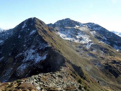 Kleiner Beil north ridge; on the right hand the ski slopes to Alpbach valley
 Traverse to Großer Beil as seen from Kleiner Beil
 Kleiner Beil summit with the traverse to Großer Beil
 Summit view with Schafsiedel range in the foreground and Großglockner group in the background
 Ascent on the north ridge to Kleiner Beil