
-
 3794 Hits
-
 77.48% Score
-
 8 Votes
|
|
Mountain/Rock |
|---|---|
|
|
47.31494°N / 12.25231°E |
|
|
Hiking, Mountaineering, Scrambling, Skiing |
|
|
Spring, Summer, Fall, Winter |
|
|
7116 ft / 2169 m |
|
|
Overview
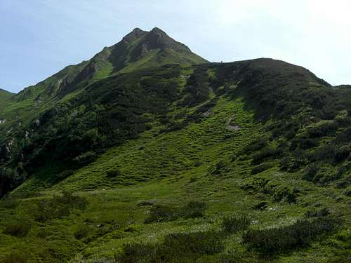
Gamsbeil summit
This beautiful summit is located within the western part of Kitzbühler Alpen, also called “Kelchsauer Alpen” in the Windau – Sperten range between the summits of Steinkogel, Speikkogel and Geige to the south and Westerachkopf and Schwarzkarkogel to the north.
The whole ridge between Steinkogel to the south and Gampenkogel to the north separates Miesenbach valley, a tributary valley to the valley of Windau and located west of Gamsbeil from Spertental / Unterer Grund to the east.
The summit itself is a rather sharp and exposed rock ridge which requires a bit of rock scrambling on its southern and northern ascent route. Due to these rocks Gamsbeil exceeds the neighbouring summits by 100 m and consequently is a nice viewpoint with breathtaking views to nearby Großvenediger mountains and the glaciers of Hohe Tauern range.
Gamsbeil is, as most of the Kitzbüheler peaks and summits, an all years outing.
In late spring, summer and autumn Gamsbeil is summited often in combination with a traverse from Gamskogel to Steinkogel, Speikkogel and Geige. Gamsbeil is the last summit of this beautiful traverse.
Another traverse option is the ridge from Gamsbeil to Westerachkopf, Schwarzkarkogel and Großer and Kleiner Tanzkogel. The complete traverse, including Gerstinger Joch, Floch and Brechhorn north of Tanzkogel is an easy but demanding and strenuous walk of 10 hours and more.
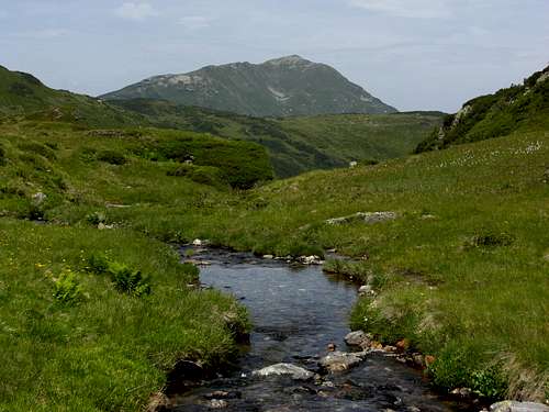
I prefer the Miesenbach valley ascent to Gamsbeil. As tributary valley to Windau, Miesenbach valley is a remote and lonely place within Kitzbüheler Alpen. In summer the alpine pastures of Miesenbach valley are full of orchids, cotton gras and alpine roses. Mieseben creek builds little ponds and waterfalls along the valley floor, great places for a rest in the sun and for bathing. Miesenbach shelter hut (also called “Neualm”), an old stone and wooden cabin in the uppermost valley is located amidst enchanting meadows and creeks some 300 meters below Gamsbeil summit, a place to dream and relax.
Getting There
Neualm and Steinbergstein
The main trailheads for Gamsbeil are:
by car:
 Gamsbeil summit Gamsbeil summit |
 View of Großvenediger View of Großvenediger |
 Gamsbeil summit Gamsbeil summit |
by railway:
Westendorf and Kirchberg for the northern trailheads and Neukirchen am Großvenediger have railway stations.
Check the railway schedules here.
The northern trailheads can be reached only by taxi; there is no bus connection!
Main Routes Overview
Miesenbach route
Trailhead: Gamskogelhütte / Windau valley
Route: Gamskogelhütte – Tagweidalm – Miesenbach valley – Miesenbachalm – Neualm – Geigenscharte – Gamsbeil summit.
Altitude difference: about 1100 m
Time: 3,5 to 4 hours
Unterer Grund route
Trailhead: Karalm / Unterer Grund
Route: Karalm – Kar Hochalm – Westerach Alm – Geige - Geigenscharte – Gamsbeil summit.
Altitude difference: about 850 m
Time: 3 hours
 Miesenbach valley Miesenbach valley |
 Neualm Neualm |
 Miesenbach valley Miesenbach valley |
Neukirchen routes
Trailhead 1: Neukirchen
Route: Neukirchen – Taubensteinkapelle – Steineralm – Steiner Hinteralm - Geige – Geigenscharte – Gamsbeil summit.
Altitude difference: about 1200 m
Time: 4 to 5 hours
Trailhead 2: Wildkogel cableway mountain station
Route: Wildkogel cableway mountain station – Gasthof Wolkenstein – Herrensteigscharte – Geige – Geigenscharte – Gamsbeil summit or
Gasthof Wolkenstein – Braunkogel – Frühmesser – Grasleitenkopf – Geige – Geigenscharte – Gamsbeil summit
Altitude difference: about 300 m or 600 m
Time: 2,5 hours or 3,5 hours
 Summit view to the west (Kröndlhorn) Summit view to the west (Kröndlhorn) |
 Summit view to Großer Rettenstein Summit view to Großer Rettenstein |
 Summit view to Steinkogel/Speikkogel Summit view to Steinkogel/Speikkogel |
Traverse routes
The ridge from Gamskogel to Steinkogel – Speikkogel – Geige – Gamsbeil and from Gamsbeil to Westerachkopf – Schwarzkarkogel – Tanzkogel is a nice and easy outing, partly on marked trails, partly off-trail.
Miesenbach valley is the best ascent – descent route for this traverse. You can bail out nearly everywhere on this ridge, if this need arises, and descend the grassy slopes to Miesenbach trails and forest roads.
I recently did so north of Westerachkogel due to some thunderstorms nearby.
 South ridge and summit South ridge and summit |
 North ridge as seen from the summit North ridge as seen from the summit |
 North ridge walk North ridge walk |
Ski routes
Miesenbach route and Unterer Grund route is a ski route, too.
Alternatively ascend from Miesenbachalm or Karalm / Unterer Grund to Westerachkogel, leave the skies there and climb the north ridge of Gamsbeil.
Red Tape & Accommodation
Red Tape
No restrictions as far as I know.
The roads to Windau and Unterer Grund are toll roads.
 Cotton gras Cotton gras |
 Waterfall + bathing pond Waterfall + bathing pond |
 Campanula barbata - bell flower Campanula barbata - bell flower |
Accommodation
Food and lodging can be found at
Mountain huts (food & lodging)
Gear & Mountain Condition
Gamsbeil is a year round mountain.
Hiking is possible from may / june to November, depending on the weather and snow conditions.
It is an easy hiking tour on narrow hiking trails, partly forest roads, with some exposure and some easy rocks to overcome on the south or north ridge in the end. In some parts the route markings are not easy to find!
Good shoes and the usual hiking gear is sufficient. Clean drinking water is abundant in Kitzbüheler Alpen so there is no need to carry tons of water with you.
 Miesenbachalm Miesenbachalm |
 Summer orchid Summer orchid |
 Special root - work Special root - work |
In winter Gamsbeil, as the adjacent summits, is a great ski tour with some scrambling on the exposed north or south ridge in the end. A combination with other summits like Steinkogel / Speikkogel or Tanzkogel is possible.
You need full ski tour gear and avalanche gear.
Check the Tirol avalanche bulletin here.
Valley weather Kirchberg / Tirol:
Mountain Weather on nearby Steinkogel:
Maps & Guide Books
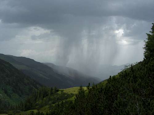
Hailstorm over Windau valley
Maps
Alpenvereinskarte 1 : 50.000; Kitzbüheler Alpen West, Nr. 34/1, Deutscher Alpenverein, 2010; - topo map with trails
Alpenvereinskarte 1 : 50.000; Kitzbüheler Alpen West, Nr. 34/1 S, Deutscher Alpenverein, 2010; - topo map with ski routes
Austrian Topo Maps:
Österreichische Karte 1 : 50.000 - UTM (ÖK50): number 3219, Neukirchen am Großvenediger
Guide Books
Available only antiquarian but indispensable guide books:
Georg Bleier / Kurt Kettner: Alpenvereinsführer Kitzbüheler Alpen, Bergverlag Rudolf Rother, München, 1984
Horst Höfler, Kurt Kettner: Kitzbüheler Alpen. Mit Skirouten. Führer für Täler, Hütten und Berge, Bergverlag Rudolf Rother, München, 1976