-
 1286 Hits
-
 79.04% Score
-
 10 Votes
|
|
Mountain/Rock |
|---|---|
|
|
Spring, Summer, Fall, Winter |
|
|
7838 ft / 2389 m |
|
|
Overview
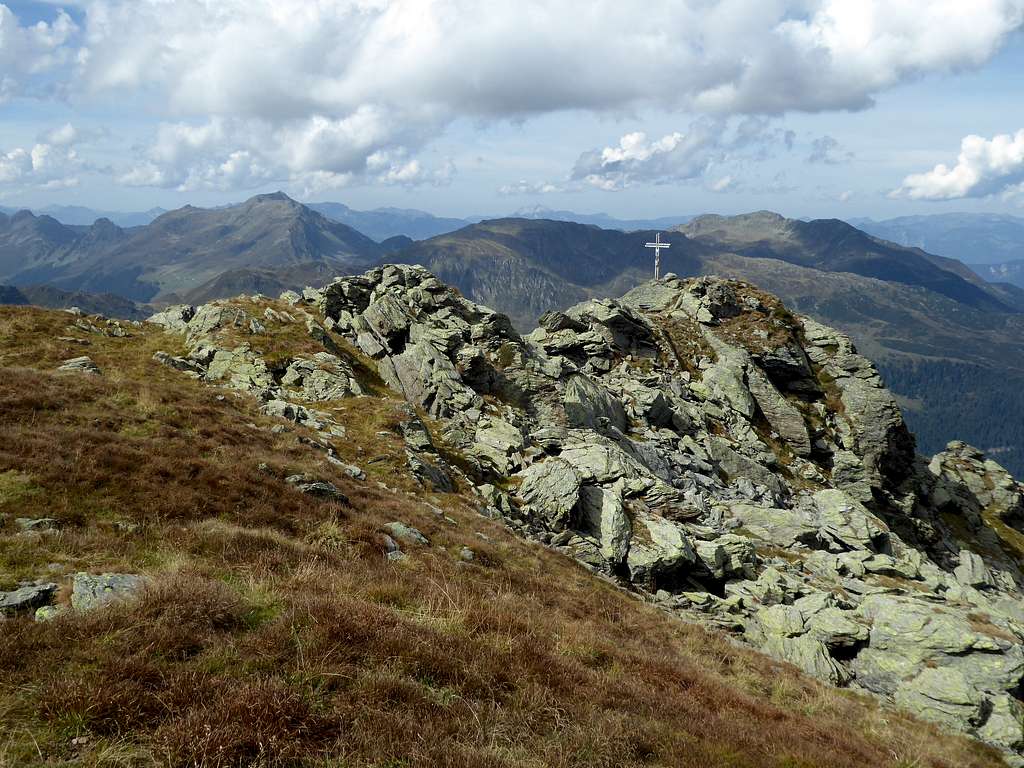
Among the many summits which can be found deep in the south of Kelchsau valley within Kitzbüheler Alpen, Pallspitze is rather wellknown. The summit is located off the main ridges bordering Langer Grund valley, the long end of Kelchsau valley. It is the culmination point of a secondary summit splitting up Langer Grund upper end in two. Pallspitze is wellknown as a ski tour outing but due to the complicated and long accessibility in winter and spring this ski tour is not often done.

In summer Pallspitze has very interesting ascents: the Schöntal ascent from Tiefentalalm parking area shows you the beautiful lake and mountain swamp of Schöntal; the Frommgrund ascent with the beautiful Frommgrund valley and the likewise beautiful Blaue Lacke lake or the off-trail-ascent via the north ridge of Pallspitze, coming from the northern neighbor summit Bärentalkopf.
To the southeast huge Ochsenkopf offers a nice traverse route from Pallspitze. The southwest neighbor is broad Kastenwendkopf above Schöntal lake, an off-trail peak and end or start point of a traverse from/to Torhelm.
Getting There
Two trailheads, Erla Brennhütte parking area and Tiefentalalm parking area, are within Langer Grund / Kelchsau valley. The Langer Grund road is a toll road.
Another trailhead can be found at Gerlos, Isskogel cableway on the south side of the mountain
You reach the Langer Grund trailheads by car:
from Munich, Salzburg or Innsbruck leave Austrian highway A 12 at exit “Wörgl Ost” and proceed on road number 178 until road number 170 to Kirchberg and Kitzbühel branches off. Go on 170 to Hopfgarten. After crossing underneath the railway turn right and immediately left onto Kelchsauer Landstraße, following Kelchsau signposts.
Drive through Kelchsau until you reach the toll station. Pay your toll (machine!) and go straight on Langer Grund forest road, passing by Alpengasthof Moderstock to Erla Brennhütte (first trailhead, Frommgrund route) or to Tiefentalalm parking area at the end of the toll road (second trailhead, Schöntal route).


You reach Gerlos by car:
for Gerlos leave highway A 12 at exit “Wiesing” and proceed on road number 169 into Zillertal valley. At the village Zell am Ziller turn left onto road number 165 which winds up to Gerlos. Best parking areas are at the eastern end oft he village at or east of Isskogel cablecar parking.
Public Transportation:
- The next railway station to the north is Hopfgarten. Bus number 4057 goes to Kelchsau. There is no public transportation to Erla Brennhütte or Tiefentalalm.
- The next railway station to the south is Zell am Ziller. Bus number 4094 goes from the railway station to Gerlos.
Routes Overview
Routes from Langer Grund
Starting at Erla Brennhütte
Frommgrund route:
Take the forest road to Richtseitbichlalm. Follow the trail and then another forest road into Frommgrund, passing by Frommalm. Climb up to Blaue Lacke lake, Pallscharte and the summit. Beautiful trail!


North ridge route:
Alternatively take the right hand forest road before you reach Frommalm. Follow this road until it reaches the north ridge of Bärentalkopf. Leave the road there and follow the broad ridge off-trail to Bärentalkopf and then the sometimes rocky ridge to Pallspitze, off-trail again. Some rock scrambling required.


Starting at Tiefentalalm
Schöntal route:
Cross the Langer Grund creek off-trail to gain the forest road on the other side of the valley. Follow this forest road, after the first switchback take the right hand trail to Hocheggalm, Jagglfeldalm and to Schöntal lake. The trail uses the west ridge to the summit.


Routes from Gerlos:
Starting at the cableway parking area take the forest road to Mostretlalm and follow from there the trail in direction of Falschriedel summit. At about 1800 m take the left hand trail and follow it to Kastenwendalm. Go up then to Pallscharte and follow the southeast ridge to the summit.


Ski routes:
The main ski route to Pallspitze is the Schöntal route from Tiefentalalm via Hocheggalm, Jagglfeldalm and Schöntal. As winter road service ends normally at Erla Brennhütte the distance between Erla Brennhütte and Tiefentalalm is an add-on and a bit of a slog on skies.
A descend is possible along the ascent route or via Pallscharte and Frommgrund, the latter only with very secure snow and avalanche condition.


Red Tape & Accommodation
No restrictions as far as I know.
The Langer Grund road is a toll road.


Accommodation can be found at
Gerlos and Königsleiten to the south
Kelchsau and Hopfgarten to the north
Mountain huts
Tiefentalalm (food and drinks)
Erla Brennhütte (food and drinks)
Gear & Mountain Condition
Pallspitze can be summited all year round.
In the hiking season you need full hiking gear and good shoes.
The ski routes are for the experienced, the north route traverses some very steep slopes, both, west and north route, are rather long ones.
Full ski and avalanche gear is required.
Check the Tirol avalanche bulletin here.


Weather condition:
Maps
Alpenvereinskarte, scale 1 : 50.000:
number 34/1, Kitzbüheler Alpen West, edition 2018 with trails and edition 2018 with ski routes, both with UTM grid
Österreichische Topographische Karte, scale 1 : 50000:
number 3219, Neukirchen am Großvenediger, with trails and UTM-grid, edition 2018