
-
 2895 Hits
-
 76.66% Score
-
 7 Votes
|
|
Mountain/Rock |
|---|---|
|
|
47.27486°N / 12.07717°E |
|
|
Hiking, Skiing |
|
|
Spring, Summer, Fall, Winter |
|
|
8100 ft / 2469 m |
|
|
Overview

Admittedly a summit called Ochsenkopf, Oxen Head, normally does not lure you out of bed and into a clear mountain morning. As for my ascent of the Oxen Head, I first only felt inquisitive to explore a long ridge traverse which is on my shortlist for some years. It is the ridge which starts at a meadow summit, called Kreuzjoch, the northernmost summit of the Schafsiedel – Salzachgeier range and which ends at – well – Ochsenkopf, which happens to be the highest point of that ridge, despite of its name.
This two days outing which crosses 13 summits was not my aim when I chose to climb Ochsenkopf in 2018; I just was curious about the condition of the southern part of this traverse and Ochsenkopf is a great lookout for this exploration.
Besides I traversed to Pallspitze, another aim on my shortlist for some years …


Ochsenkopf is the culmination point of the Schafsiedel – Salzachgeier subrange of Kitzbüheler Alpen and, besides of the sidekick Falschriedel south of our summit, the southernmost peak. Dominating above three valleys, Frommgrund to the north, Müllachgrund to the east and Nederbach valley to the south, Ochsenkopf is quite an impressive mountain within the normally gentle peaks of Kitzbüheler Alpen.
And, as I found out, the north and the west route to this mountain are both leading through a fantastic and intriguing landscape. I would not like to miss this outing on Oxens Head ….
Getting There
Trailheads for Ochsenkopf are:
- Erla Brennhütte / Langer Grund to the north
- Tiefentalalm / Langer Grund to the west
- Königsleiten or Königsleitenspitze to the south


You reach the Langer Grund trailheads by car:
from Munich, Salzburg or Innsbruck leave Austrian highway A 12 at exit “Wörgl Ost” and proceed on road number 178 until road number 170 to Kirchberg and Kitzbühel branches off. Go on 170 to Hopfgarten. After crossing underneath the railway turn right and immediately left onto Kelchsauer Landstraße, following Kelchsau signposts.
Drive through Kelchsau until you rech the toll station. Pay your toll (machine!) and go straight on onto Langer Grund forest road, passing by Alpengasthof Moderstock to Erla Brennhütte (first trailhead, north route) or to Tiefentalalm parking area at the end of the toll road (second trailhead, west route via Pallspitze).

You reach Königsleiten by car:
for Königsleiten leave highway A 12 at exit “Wiesing” and proceed on road number 169 into Zillertal valley. At the village Zell am Ziller turn left onto road number 165 which winds up to Gerlospass above the Durlaßboden dammed lake. Go left there an go on to Königsleitenspitze cable car valley station (parking area).
Public Transportation:
- The next railway station to the north is Hopfgarten. Bus number 4057 goes to Kelchsau. There is no public transportation to Tiefentalalm.
- The next railway station to the south is Zell am Ziller. Bus number 4094 goes from the railway station to Königsleiten.
Routes Overview
Routes Overview:
North Route:
Take the forest road which branches off about 200 m north / below Erla Brennhütte to the left. At the third switchback go right to the already visible Richtseitbichlalm. Take the trail there which leads you into Frommgrund valley. At a height of 1430 m you reach the end of another forest road, proceed on that road to Frommalm.


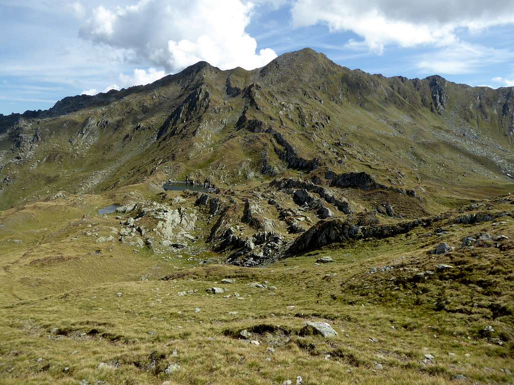
At Frommalm starts a trail which leads you southbound up into upper Frommgrund and up to Pallscharte. Turn left at the beautiful lake of Blaue Lacke before you arrive at Pallscharte. Ascend off trail the northwest ridge of Ochsenkopf. There is a broad chute left of the rocky ridgecrest, use that chute to go up to the north ridge of Ochsenkopf. 5 minutes over scree on a path to the summit.


West Route:
Best traverse off-trail the valley ground from Tiefentalalm parking area to the east, crossing Langer Grund Ache and ascend shortly the east slope until you reach a forest road. Alternatively park your car at the bridge crossing the Lange Grund Ache some 2 km before you arrive Tiefentalalm and proceed on the forest road, branching off the street to the left.
Follow the road (1 switchback) first to the south then to the north until a trail branches off to the right. Go on that trail up to Hocheggalm, cross some creeks and ascend to Jagglfeldalm and further on to the ruined Schöntalalm. You reach beautiful Schöntalsee, spectacular landscape! Turn left there and ascend Pallspitze on a narrow marked trail.


At Pallspitze turn right on the trail descending eastwards to Pallscharte and Blaue Lacke. Go on like described above for the north route.
As you know me as a traverse monster you can combine both routes to a nive traverse loop!
South Route:
From Königsleiten valley station there are several forest roads and a trail leaving up to Königsleitenspitze (about 700 m of altitude difference). As this is a skiing area in winter the ascent however is no great fun.
A shortcut is to use the Königsleiten cableway up to the mountain station some meters lower than Königsleitenspitze.
From Königsleitenspitze descend on a trail to Sattelscharte and climb the summit of Falschriedel on its southeast ridge. From Falschriedel follow the trail on the connecting ridge to the summit of Ochsenkopf.

Ski Routes:
Both the north route and the west route are ski routes, too. Pallspitze can be included easily if you ascend on the west route and ski down the north route.
Red Tape & Accommodation
No Red Tape as far as I know.
Accommodation can be found at
Gerlos and Königsleiten to the south
Kelchsau and Hopfgarten to the north
Mountain huts
Tiefentalalm (food and drinks)
Erla Brennhütte (food and drinks)
Alpengasthof Moderstock (overnight stay possible)
Gear & Mountain Condition
Ochsenkopf can be summited all year round.
In the hiking season you need full hiking gear and good shoes. The summit routes to Ochsenkopf are strenuous hikes on narrow and sometimes steep mountain trails and - near the valleys - forest roads. The last ascent on the north and west route is off-trail.
The south route is easy but, as you have to cross a ski area or have to take a cable car, the south side is not recommended as a satisfying outing.

The ski routes are for the experienced, the north route traverses some very steep slopes, both, west and north route, are rather long ones.
Full ski and avalanche gear is required.
Check the Tirol avalanche bulletin here.
Weather Gerlos:
Maps
Alpenvereinskarte, scale 1 : 50.000:
number 34/1, Kitzbüheler Alpen West, edition 2018 with trails and edition 2018 with ski routes, both with UTM grid
Topografische Karte von Österreich, scale 1 : 50.000:
number 3219, Neukirchen am Großvenediger, BEV Bundesamt für Eich- und Vermessungswesen, Wien