
-
 1899 Hits
-
 75.81% Score
-
 6 Votes
|
|
Mountain/Rock |
|---|---|
|
|
Spring, Summer, Fall, Winter |
|
|
8182 ft / 2494 m |
|
|
Overview
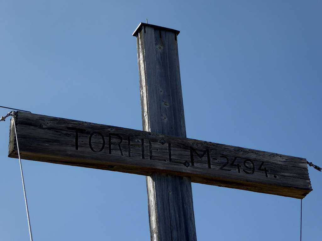
Torhelm is part of Kelchsauer Alpen of the Kitzbüheler Alpen and belongs to the Kreuzjoch – Torhelm range. Being one of the highest peaks of Kitzbüheler Alpen and being easily accessible throughout the year, Torhelm can be crowded on sunny days.
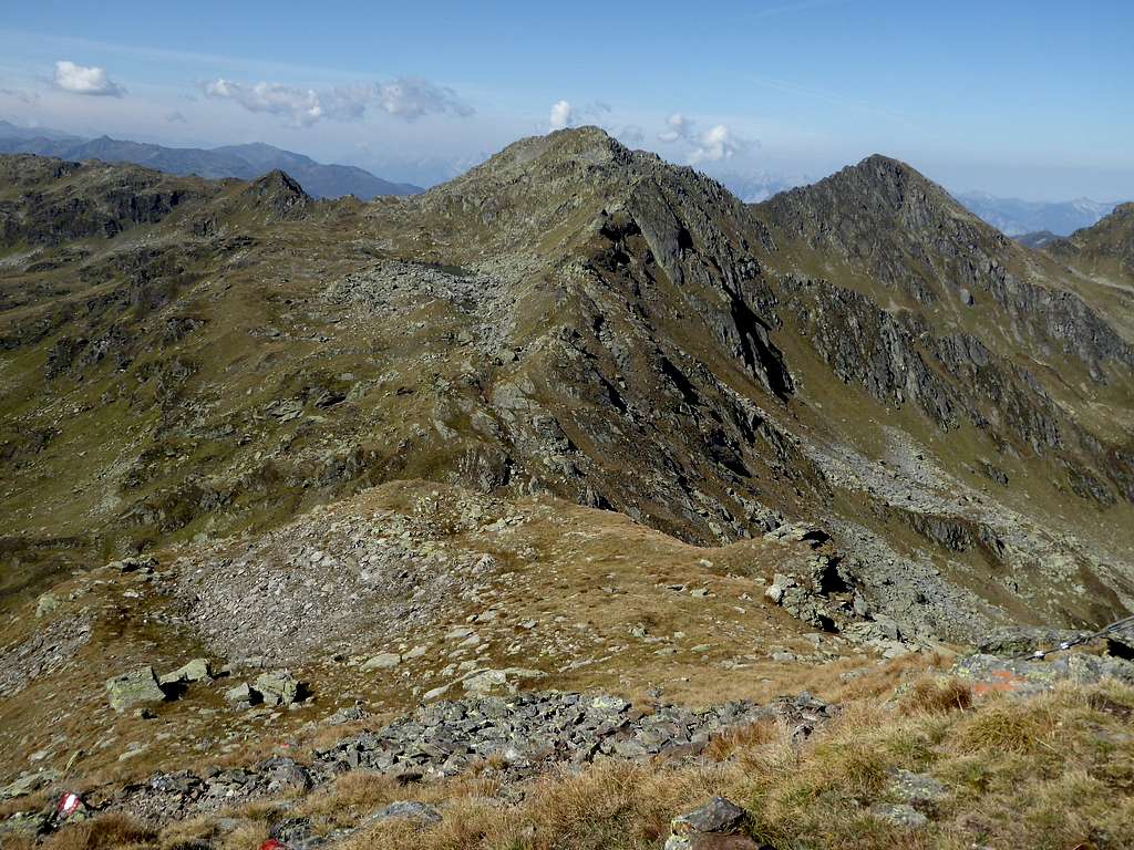
Torhelm marks the southern end of the long, north – south running ridge, starting at Schatzberg to the north. At Torhelm the ridge splits up:
- to the east it drops down to Kastenwendkopf
- to the west it embraces the high valley of Wilde Krimml and culminates at Katzenkopf and Kreuzjoch, the two highest peaks of Kitzbüheler Alpen, the latter being only 60 m higher than Torhelm
Thus Torhelm is the culmination point of three valleys and their cirques: Wilde Krimml to the south, sadly enough “decorated” with a skiing area, Langer Grund to the northeast and Märzengrund to the northwest.


Best trailhead for Torhelm is Langer Grund / Tiefentalalm. There are two normal routes up to the summit.
Very nice is the traverse Torhelm – Schwarzer Bär – Kastenwendkopf with the trailhead at Tiefentalalm, partly an off-trail adventure and a long day. I did it many years ago, unfortunately I made no fotos.
Another traverse route is the ridge Torhelm – Grubachkogel with an epic extension possibility to Regenfeldjoch, Niederjochkogel and Sonnenjoch.
Ski touring is possible starting from the south side (Gerlos, Wilde Krimml skiing area) or from the northeast (Erla Brennhütte, Langer Grund).
Getting There
Best trailheads are
- Tiefentalalm / Langer Grund (in winter and spring: Erla Brennhütte / Langer Grund) to the northeast.
- Gerlos to the south
Tiefentalalm by car:
From Munich, Salzburg or Innsbruck leave Austrian highway A 12 at exit “Wörgl Ost” and proceed on road number 178 until road number 170 to Kirchberg and Kitzbühel branches off. Go on 170 to Hopfgarten. After crossing underneath the railway turn right and immediately left onto Kelchsauer Landstraße, following Kelchsau signposts.
Drive through Kelchsau until you rech the toll station. Pay your toll (machine!) and go straight on onto Langer Grund forest road, passing by Alpengasthof Moderstock and Erla Brennhütte until the toll road ends at Tiefentalalm parking area.


Gerlos by car:
For Gerlos leave highway A 12 at exit “Wiesing” and proceed on road number 169 into Zillertal valley. At the village Zell am Ziller turn left onto road number 165 which winds up to Gerlospass. Park at the Gerlos Isskogel cableway parking area.
Public Transportation:
The next railway station to the north is Hopfgarten. Bus number 4057 goes to Kelchsau. There is no public transportation to Tiefentalalm.
The next railway station to the south is Zell am Ziller. Bus number 4094 goes from the railway station to Gerlos – Isskogel cablecar station.
Routes Overview
Route from Langer Grund / Tiefentalalm:
From Tiefentalalm take the forest road to the south until you reach Oberkaralm. Follow the trail starting at the Alm into the uppermost part of Langer Grund valley. Ascent at the end of the valley more steeply to old and withered Öfeleralm amidst wonderful meadows. The trail ascends west then south into the broad Öfeler col. Follow the trail southbound to Torhelm summit.
Ski Route from Langer Grund:
The ski route runs along this route, using the north and northeast slopes of Torhelm above Öfeleralm and omitting Öfelerscharte. The route starts at Erla Brennhütte, some km north of Tiefentalalm, due to restricted winter service in these Kitzbühel valleys.


Alternative Route from Tiefentalalm:
Alternatively follow the forest road starting at Tiefentalalm to the northwest and ascend to Foissachalm. Take the trail leaving the forest road to the left in front of the Alm hut and follow it up to Regenfeldalm. A beautiful panorama trail starts there to the south below the ridge of Grubachkogel. It reaches the above mentioned normal route at Öfeleralm. Follow the above described route to the summit.


Route from Gerlos:
From Gerlos / Innertal follow the forest road alongside Krummbach creek to Moseltretalm, Krummbachalm and Wilde Krimmlalm. At the first trail junction follow the trail to the right up to Maurerschartl col and the west ridge to Torhelm.
As the ski area of Wilde Krimml is not far away Torhelm should be easily accessible for ski touring via its south side to Maurerscharte.


Traverse Routes:
- Torhelm - Öfeler col - off trail to Grubachkogel ridge - col south of Regenfeldjoch (from here descent to Regenfeldalm, Foissachalm and Tiefentalalm possible) - Regenfeldjoch - Heutal col - Niederfeldjoch - Niederjoch col - Sonnenjoch; long and epic
- Torhelm - Schwarzer Bär - Kastenwendkopf - Schöntalalm - Hocheggalm - Tiefentalalm; a traverse to be recommended!
Red Tape & Accommodation
No Red Tape as far as I know.
Accommodation can be found at
Gerlos to the south
Kelchsau and Hopfgarten to the north
Mountain huts
Tiefentalalm (food and drinks)
Erla Brennhütte (food and drinks)
Alpengasthof Moderstock (overnight stay possible)
Gear & Mountain Condition
Torhelm can be summited all year round.
In the hiking season you need full hiking gear and good shoes. The summit routes to Torhelm are easy hikes on marked mountain trails and - near the valleys - forest roads. The traverse routes, however, require some rock scrambling up to grade I moves and a sense for orientation.
The ski routes are easy ones, the route from Langer Grund can be a long valley slog, depending on how far winter road service is going.
Full ski and avalanche gear is required.
Check the Tirol avalanche bulletin here.


Weather:
Maps
Alpenvereinskarte, scale 1 : 50.000:
number 34/1, Kitzbüheler Alpen West, edition 2018 with trails and edition 2018 with ski routes, both with UTM grid
Topografische Karte von Österreich, scale 1 : 50.000:
number 3219, Neukirchen am Großvenediger, BEV Bundesamt für Eich- und Vermessungswesen, Wien