
|
|
Mountain/Rock |
|---|---|
|
|
36.12273°N / 115.49584°W |
|
|
Hiking, Trad Climbing, Sport Climbing, Aid Climbing, Scrambling, Canyoneering |
|
|
Spring, Summer, Fall, Winter |
|
|
5440 ft / 1658 m |
|
|
Overview


RED ROCKS UNDER ATTACK- read more here: Save Red Rocks.
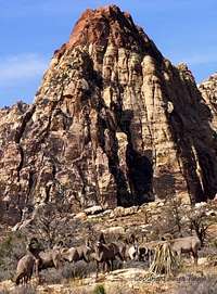
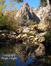
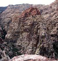
Mescalito is the pyramid-shaped formation splitting the Pine Creek Canyon within the Red Rock Canyon National Conservation Area (approximately 20 minutes driving time from downtown Las Vegas). From the approach trail, Mescalito looks like a miniature version of its near neighbor, Rainbow Mountain. Both share similarily colored characteristic rock bands - grayish lower portions and redish upper regions.
Swain's guide book only mentions in passing that an "extension" of the Dark Shadows route can be used to access the summit however he does not provide a topo or a description on how to continue past the 4th or 5th pitch. More information is provided in Joan Urioste's guide book (out of print; will provide the info. here once I receive the guide book). Joann Urioste's guide book claims that the summit can be reached from top of Cat in the Hat with 3rd and 4th class scrambling (+some fifth class moves). The numerous established climbing routes that exist on Mescalito range in difficulty from about 5.6+ to 5.12. Note that the summit elevation listed was pointed out by bc44caesar who in turn was referring to the Branch Whitney guidebook (see books listed).
Summit Scramble Route Info. (courtesy of bc44caesar):
"Just for your info, Hiking Southern Nevada by Branch Whitney describes a 3rd class route to the summit that I used. Route finding was challenging, but there are occasional cairns. "
Getting There
From downtown Las Vegas (or from I 15), drive west on Charleston Blvd. through a suburbia of Vegas (apartment comlexes and shopping malls). As you leave the human development (just drops off beyond one of the intersections) behind, Charleston turns into NV SR 159. Follow NV SR 159 to the well marked scenic loop road on your right. Take the park's scenic loop (one way only) drive to Pine Creek parking lot (approximately mile 10 of the loop road).
From the parking lot, follow a well-worn trail into Pine Creek Canyon past the Fire Ecology Trail and an old home site (not very much left). At this point, Mescalito is dead ahead of you. Keep hiking towards it.
Numerous routes on Mescalito's walls (south, east, and north faces) are described by Swain including some area "classics" such as Cat in the Hat (5.6+) and Dark Shadows (5.8-). Once you get near its base, stay on the trail to reach the Dark Shadows Wall on Mescalito's north wall (the right hand fork of the canyon) or go left traversing below the east face of the mountain (into the south drainage) to reach routes on the east and south faces (such as Cat in the Hat).
If heading towards Cat in the Hat, Swain's guide book instructs to take the left fork in the main trail for about 75 yards and then follow the tail on the Mescalito side of the creek bed. In actuality, there are numerous 'social' trails (all very faint and overgrown) headed in that general direction. At some point a bushwack becomes necessary. The key is to keep well above the creek bed as you're traversing below Mescalito, BUT not too high or you'll be faced with some (easy) downclimbing.
Summit Descent
From the summit, you will travel westward back across the sandstone and toward the limestone far away and above. While doing so, start working your way to the south side of the crest over ramps and ledges.
Only a short distance away from the summit is a fairly large drop-off to a saddle. Work your way down to the south side of the saddle, make a quick class 4 (or so) move, and then scrambling back up to the other (west) side of the saddle.
From there, keep moving west along the sandstone crest. After perhaps 1/8 mile or so from the saddle, you will look for a chute to the south (I recall a semi-prominent tree nearby). Dropping into the chute a short distance, find your way onto a series of ramps and ledges below that will start leading you down toward the south fork of Pine Creek Canyon.
Once you get onto these ledges, it's pretty simple to gradually work
your way down to the canyon bottom. But - Don't make the mistake of descending too quickly - you will likely cliff-out. Instead, keep gradually working your way down (and west) until you reach a sort of gully that leads down to the bottom of the canyon over class 2 terrain.
Red Tape
The scenic loop road is open 6am to 5pm in winter and 6am to 6pm in summer. Having your car parked at one of the trail heads along this road outside the "open hours" will earn you a $50 ticket. This can be avoided by requesting a "Late Exit Permit" which is free of charge by calling 702-515-5050 and leaving a detailed message (can call on day of the climb before 4 pm). Note that there are restrictions on which climbs the late exti permit will be granted for. Generally, sport routes and other "short" climbs do not qualify for this permit; long multi-pitch routes do. Listen to the recorded message for details.The Park Service charges a fee of $5 per day (per vehicle) or $20 annual pass to access the scenic loop road. The annual National Parks' Pass also works. The toll booths are unattended (hence you get a free pass) on certain holidays (ex. Thanksgiving).
Park service allows dogs in the backcountry. Please keep them leashed and pick up their feces.
When To Climb
As it is true for all climbing in Red Rocks, the question of "when to climb" (or more specifically, "when to climb comfortably") varies from route to route. As an example, Cat in the Hat has a southern exposure thus making it suitable for climbing on cooler days. The slight shadowing provided by the surrouding canyon walls would also probably make the first pitch or two of this route suitable even in the summer."When NOT to climb" is easier to answer: DO NOT climb after rain. Give the rock at least 24 hours (or more depending on duration/intensity of the rain) to dry out following a rainy period. According to Swain's guide book, sandstone becomes more brittle when wet.
Camping
The "13-mile campground" on NV-SR159 (driving from Vegas, you will see a sign for the campground located on left side of the road before reaching the Red Rocks marker) provides the closest overnight accomodations in the area. There are no reservations except for group sites - first come, first serve basis. In addition to the standard drive-up sites, there are numerous walk in sites (park in the communal parking lot and walk to your tent). The campground charges $10/night for both types of sites (self issued). Despite the proximity to Las Vegas, the campground has a safe feel to it as it is frequently patrolled by the Park Service(?). The campground has running water and numerous rest rooms. The campsites have picnic tables and fire pits. There are no trees on the premises - the campground is no doubt extremely hot in the summer months.Mountain Conditions
BLM Red Rock CanyonNational Conservation Area
HCR 33, Box 5500
Las Vegas, Nevada, 89124
Phone: (702) 363-1921
Climbing Rangers at Red Rocks (very nice and helpful):
702-515-5138 or
702-515-5042
Loop road late exit pass line (see Red Tape section above):
702-515-5050
Guide Books
The Falcon guide to the area, "Rock Climbing Red Rocks" by Swain, is an excellent resource. Contains some pictures of routes, nice approach maps, and great topo's of some of the more popular routes. Swain, however, does mention the fact that he has not climbed any of the routes listed for Mt. Wilson for example.An out of print guide book by one of the Red Rocks climbing pioneers, Joann Urioste (the little red book) can also be found (was able to buy a used copy of it at Amazon.com). Urioste talks of routes not mentioned in Swain's book (she describes the "Regular Route" to summit of Mescalito for example) but does not provide much details on many of them. There are no route topo's in her guide book but she does provide some route overview photographs for select routes.
Even though some overlap exists between the two guide books, each DOES contain some unique material. For those planning on doing the less popular routes at Red Rocks, Urioste's book is definitely worth having.
Additionally, Super Topo sells a set of topos for select routes at Red Rocks, including the two routes presently listed for Mescalito. Thanks to mtntrail2 for pointing out this information.
External Links
- SuperTopo.com
Chris McNamara's online topos and guidebook of Red Rock Select. These are outstanding guides and topos of Red Rocks and other rock climbing areas.
- Additional Red Rock Select Routes Info.
This page provides additional information on some of the routes in Red Rocks including the two presently listed for Mescalito.
- Customized and Personalized USGS-Maps-Based Topos
This is an outstanding place to purchase USGS quality maps that have been spliced together according to customer's needs. Reasons:
1. You get to generate the map for the area you need and can preview that map online before ordering.
2. Maps are printed on waterproof/tearproof paper.
3. You can customize which coorinate system to have printed on it and how it'll be displayed (ticks vs. grid lines).
4. Price is excellent (depending on size chosen, from $9.95 to $24.95, the latter of which are huge, wall display quality maps). This really is a good price considering that if you go to your local REI, you'll pay about $6 to $8 PER MAP (obviously might need multiple ones) printed on regular paper.
5. Timely shipping. If ordered on a Monday morning, will usually get to you that same week by Friday (USA of coruse) even via standard mail. Most places that sell USGS maps take FOREVER to get the product to you.
6. You can customize the title of your map to include your name.
I don't work for these guys, but have been ordering maps from them for the past 6 months and have been satisfied every time.
- GPS Coordinates for Start of Route
An excellent web page that (among other things) gives the GPS coordinates for the starting point of Cat in the Hat and other Red Rock routes. Beautiful rock climbing photography from around the U.S. is also included.
- Additional Cat and Dark Shadows Route Photos
This page has a few good photos of Cat in the Hat and Dark Shadows climbs on Mescalito.
rpc - Nov 11, 2010 6:17 pm - Hasn't voted
Re: lat/lonthanks Jim - sorry it took me a while. should be all squared now.