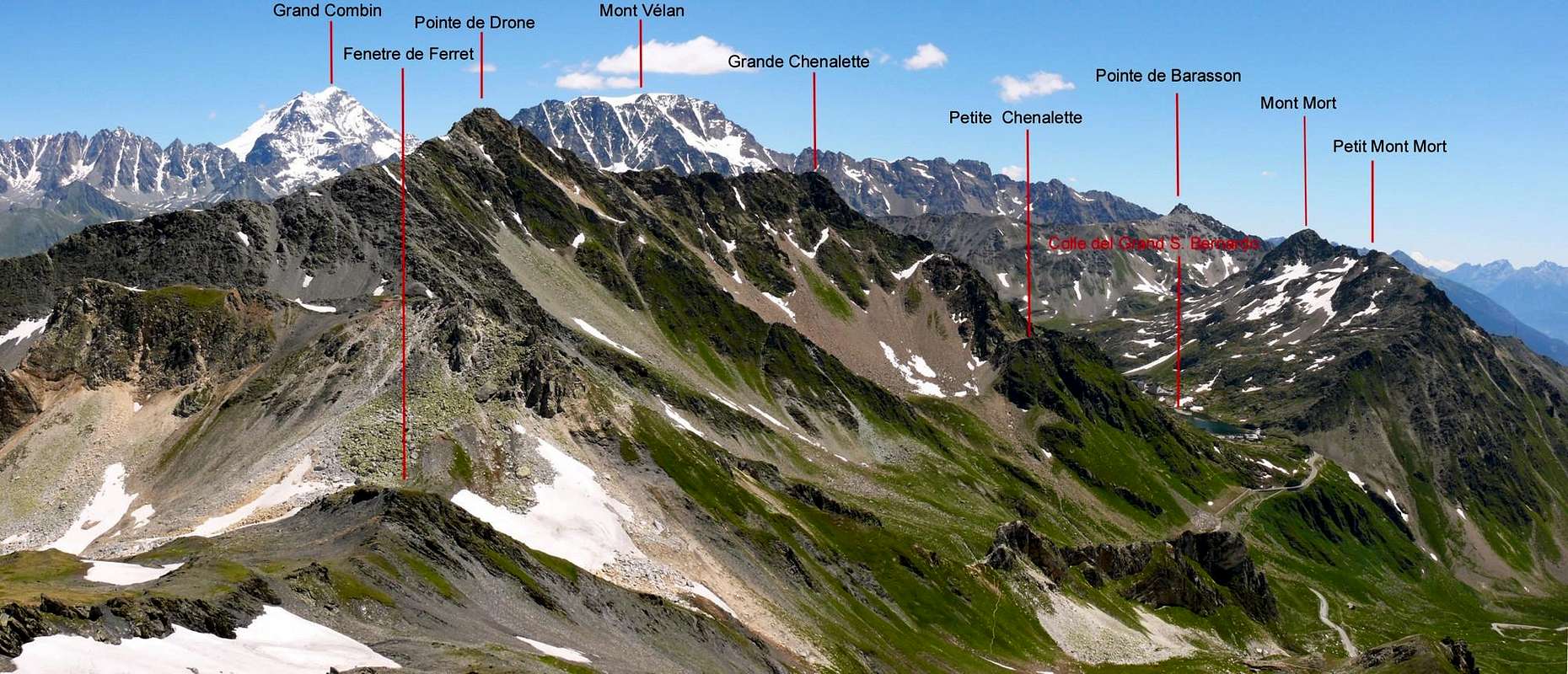
Strong mountain of the border ridge coming down from Mont Vélan to Gran San Bernardo Pass. It is placed East of the pass, and has 3 summits (from E to W): the Petit Mont Mort (2.820m), Sommet Central (2.829m) and Grand Mont Mort (2.867m). Good views on Grand Combin, Mont Vélan and Grand Golliat or Golliaz.
Robusta montagna situata sulla cresta di confine che dal Mont Vélan scende al Colle del Gran San Bernardo, dominandolo da oriente, a cavallo tra l'omonima valle e la Valle d'Entremont svizzera. Possiede tre cime, poste sull'asse EW, denominate Petit Mont Mort (2.820 m), Sommet Central (2.829 m) e Grand Mont Mort (2.867 m). Ottime vedute sul Grand Combin, Mont Vélan e Grand Golliat o Golliaz.
N-NE Arête (Integral): Osvaldo Cardellina, (Jul 16th, 1995), in descent.
Getting There
BY CAR:
From Torino, Milano, etc: Motorway A5. Exit Aosta Est.
From France: through Mont Blanc Tunnel or Petit St. Bernard Pass. It isn't necessary to enter in Motorway A5, you can drive through SS.26 Aosta direction.
BY PLANE:
Aeroporto "Corrado Gex" Saint Christophe (Aosta).
Itinerary
From Aosta, along the SS.27 of gran San Bernardo, crossing Gignod (988m), Etroubles (1.264m), and Saint Oyen (1.373m), leave to the left the road to the tunnel and go up to Saint Rhèmy en Bosses (1.632m) along the valley leading to the Pass of Gran San Bernardo (2.469m; Mansio Romana, Plan de Jupiter, Albergo Italia, Lago e Hospice). Pass the customs and descend along the road of Combes des Morts till a small car parking near the ventiduct of the Tunnel.
Dalla Città di Aosta (583 m) salire lungo SS.27 del Gran San Bernardo, e, dopo aver superato i Paesi di Gignod (988 m), Etroubles (1.264 m), e Saint Oyen (1.373 m), lasciare sulla sinistra la strada che porta al Tunnel del Gran San Bernardo. Salire verso Saint Rhèmy en Bosses (1.632 m) continuando lungo il vallone che porta al Valico del Gran San Bernardo (2.469 m; Mansio Romana, Plan de Jupiter, Albergo Italia, Lago e Hospice). Varcare la frontiera e scendere lungo la carrozzabile della Combes des Morts sino allo sfiato del Tunnel, con piccolo parcheggio.
Route
Start walking along the dirt road, on the west side of the stream, ascending the Barasson combe and passing La Drance and the path to the Hospice; when the road turns to NW start along a path and walk up to the Western Pass of Barasson (2.635m). Along the SE ridge, on debris, bad rocks and small steps (better turn them on the right or on the left side) to the summit (2h'00/2h'30). Descent: N-NE Arête and E slope direct.
Prendere la strada poderale che, oltrepassata La Drance ed il sentiero per l'Hospice, risale l'intera Comba di Barasson, fiancheggiando a W l'omonimo torrente; quando questa svolta bruscamente verso NW, prendere il sentiero e seguirlo sino al Colle Occidentale di Barasson (2.635 m). Dal colle si percorre la cresta SE su tratti detritici, sfasciumi, blocchi instabili e alcuni piccoli salti, aggirabili a N oppure a S (2h'00/2h'30). Discesa: Cresta N-NE, poi direttamente per il versante E.
Difficulty
This route can be considered F+, PD-.
L'itinerario è classificato F+, PD-.
Gear
Hiking gear.
Da Escursionismo.
Campings
Remember that free camping is forbidden (except for emergency reasons, over 2.500m, from darkness until dawn).
Mountain Conditions
You can get meteo information at the official site of the Regione Valle d'Aosta:
FONDAZIONE MONTAGNA SICURA Villa Cameron, località Villard de la Palud n° 1 Courmayeur (AO) Tel: 39 0165 897602 - Fax: 39 0165 897647.
SOCIETA' DELLE GUIDE DELLA VALPELLINE Etroubles-Strada Nazionale, n° 13 - Tel +39 0165 78559 - Valpelline-Loc Capoluogo, n° 1 - Tel +39 0165 713502 (AO) Italia.
A.I.NE.VA. (Associazione Interregionale Neve e Valanghe).
Useful numbers
Protezione Civile Valdostana località Aeroporto n° 7/A Saint Christophe (Ao) Tel. 0165-238222.
Bollettino Meteo (weather info) Tel. 0165-44113.
Unità Operativa di Soccorso Sanitario Tel. 118.
Acknowledgements
I am greatly indebted to my friend "Osva" for the detailed description of the route. In addition i want to thank Gabriele Roth for the translation of the text from italian.
Parents refers to a larger category under which an object falls. For example, theAconcagua mountain page has the 'Aconcagua Group' and the 'Seven Summits' asparents and is a parent itself to many routes, photos, and Trip Reports.

 7948 Hits
 89.01% Score
 28 Votes