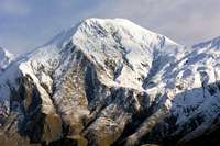
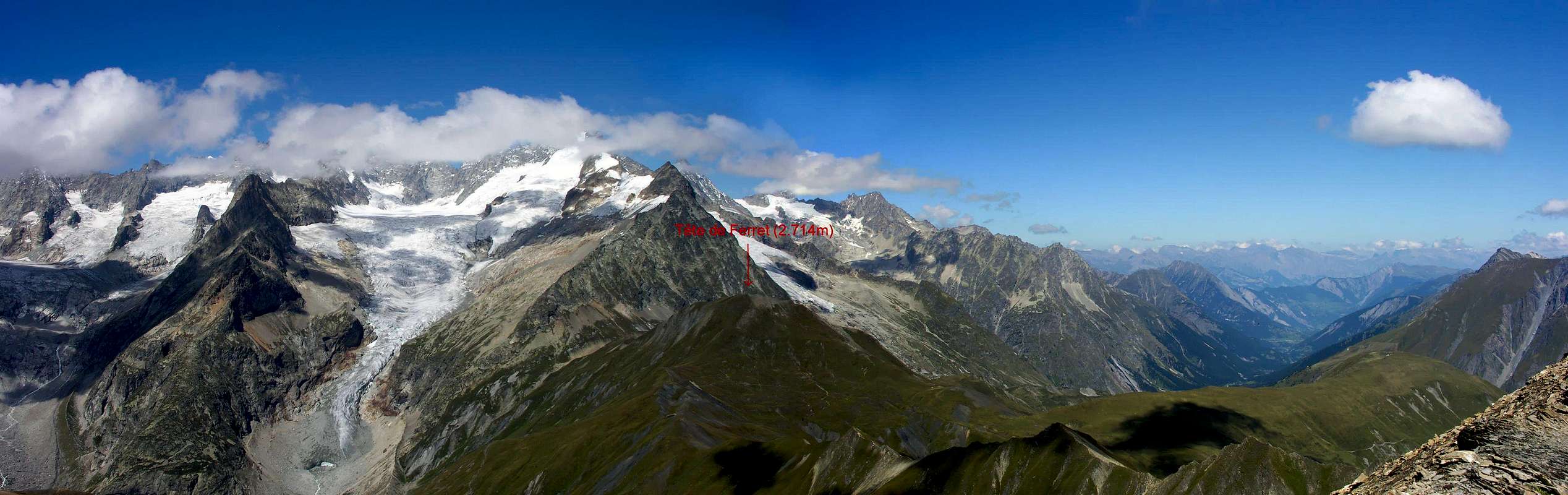
Large, rounded and predominantly grassy elevation on the border crossing between Italy and Switzerland and between the Col du Grand Ferret (2.537m) to the East and the Petit to the opposite side (2.490m). At this point, after the Mont Dolent (3.821m) and its Eastern shoulder or Mont Grapillon (3.620m), Petit Grapillon (3.327m) and Punta Allobrogia (3.164m) ends the most Eastern part of the Mont Blanc Chain. The Western Pennine Alps begin in the direction of Mont Velan (3.734m) and Grand Combin de Valsorey (4.184m) and Grand Combin de Grafeneire (4.314m), even to the Combin de Tsassette (4.141m). Easy and hiking excursion, but it requires some caution, because the trail often crosses steep grassy slopes not to be underestimated and in which misfortunes have already been recorded. Beautiful views of the divisional mountain chain from the Grandes Jorasses descend towards North-northeast to progression the various Aiguilles like the Aiguille de l'Eboulement, the Petites Jorasses, the Leschaux, the Talèfre and the Triolet, to quote the most famous. In the North, the view extends towards the Swiss Val Ferret, while in South East there are the Grand Golliaz (3.237m) and the Grande Rochère (3.326m).
Larga elevazione arrotondata e prevalentemente erbosa posta sulla cresta di confine tra la Val Ferret italiana e la Svizzera e collocata tra il Col du Grand Ferret (2.537 m) ad Est e quello del Petit sul versante opposto (2.490 m). In questo punto, dopo il Mont Dolent (3.821 m) e la sua spalla Orientale o Mont Grapillon (3.620 m), Petit Grapillon (3.327 m) e Punta Allobrogia (3.164 m) termina la parte più Orientale della Catena del Monte Bianco, mentre iniziano le Alpi Pennine Occidentali in direzione di Mont Velan (3.734 m) e Grand Combins de Valsorey (4.184 m), de Grafeneire (4.314 m) ed anche verso il Combin de Tsassette (4.141 m). Gita facile e di carattere escursionistico, ma tale da richiedere una certa prudenza, perché il sentiero attraversa spesso ripidi pendii erbosi da non sottovalutare e nei quali si sono già registrate delle disgrazie. Belle vedute sulla catena divisoria che dalle Grandes Jorasses scende verso Nord-nordest raggiungendo in progressione le varie Aiguilles come l'Aiguille de l'Eboulement, le Petites Jorasses, la Leschaux, il Talèfre ed il Triolet, per citare le più famose. A Settentrione la vista spazia verso la Val Ferret svizzera, mentre a Sudest si ergono il Grand Golliaz (3.237 m), sopra quella italiana, e la Grande Rochère (3.326 m).
First Ascents
First on the summit: Unknown.
In winter: Unknown.
Getting There
From A5 Morgex toll drive along the SS.26 toward Courmayeur, cross it and once in Entréves follow for the Val Ferret, passing towards North the Villages of la Palud (1.370m), Plampincieux (1.593m) e la Vachey (1.642m). Till the end of the road (Arnouva - 1.769m) - car parking, where begin the trail on foot.
Dall'uscita dell'Autostrada A5 nel comune di Morgex (921 m) proseguire lungo la SS.26, verso il Paese di Courmayeur (1.228 m) e, raggiunta la Frazione di Entrèves (1.326 m), continuare verso N lungo la Val Ferret. Oltrepassate le Frazioni di: la Palud (1.370 m), Plampincieux (1.593 m) e la Vachey (1.642 m) si raggiunge l'Alpeggio di Arnouva (1.769 m palina di divieto di transito alle auto), dove inizia l'itinerario a piedi.
Approaches & Route
From Arnouva follow along the road (open only to the cars of the ones that have a booking at Rifugio Elena) and along the path n° 25 get the Refuge.
A) - Through the West-northwest Crest To the last curve, to take the path n° 24 that it brings du to the Petit Ferret Pass (2.540m). No continue following the indications that conduct to the two Bivacchi Fiorio (2.800-2.810m2h'30/3h'00); but, abandoned this route when it is turning southwest, proceed to the Colle del Petit Ferret, reaching the same in a short time. From the hill follow to the East-southeast the easy border crest on pathl trails and easy rocks; overtaking a small elevation (2.558m) and the next depression, you pass a slope of debris reaching the summit (0h'30/0h'40 from the hill; 2h'30 altogether from Arp Nouva or Arnouva).
B) - Through the South-southeastern Slope Reach in short time the Refuge Elena though this trail: from Arnouva (1.769m) follow along the road (open only to the cars of the ones that have a booking at Elena Shelter) and along the path n° 25 get the Prè de Bar Pasture (2.062m - 1h'30). Along the path up to Tramail (2.264m) and the following junction (2.316m). Leave, on the right, the path to Col du Ban Darrey and follow toward North on always easy path n° 25; reached the Grand Ferret Hill to continue along the easy and grassy Southern Slope arriving shortly and easily to the Summit (0h'25/0h'35 from hill; 1h'30/2h'00 by Elena Refuge).
Da Arnouva (1.769 m) proseguire per breve tratto sulla strada, chiusa al traffico, sino al bivio (1.793 m) dove parte il sentiero n° 25 per il Rifugio Elena.
A) - Per la Cresta Ovest-nordovest All'ultimo tornante, prendere il sentiero n° 24 che porta al Colle du Petit Ferret (2.540 m). Non continuare seguendo le indicazioni che conducono ai due Bivacchi Fiorio (2.800 m – 2.810 m2h'30/3h'00); ma, abbandonata questa via quando questa svolta a Sudovest, procedere verso il Colle del Petit Ferret raggiungendo lo stesso in breve tempo. Dal Colle seguire verso Est-sudest la facile cresta di frontiera su tracce di sentiero e facili roccette; scavalcata una piccola elevazione (2.558 m) e la depressione, si supera un pendio di detriti pervenendo alla Sommità (0h'30/0h'40 dal colle; 2h'30 complessivamente da Arp Nouva).
B) - Per il Versante Sud-sudest Raggiungere in breve tempo il Rifugio Elena dal fondovalle con questo percorso: da Arnouva (1.769 m) proseguire per breve tratto sulla strada, chiusa al traffico, sino al bivio (1.793 m), dove parte il sentiero n° 25 per il Rifugio Elena ed il Colle del Gran Ferret. Risalire alla Tsa de Djuan (1.933 m) e continuando verso Nord, con alcuni saliscendi, percorrere alla base tutto il Vallone de la Belle Combe per entrare in quello di Combette arrivando al Rifugio Elena, ristrutturato, presso l'Alpe Prè de Bar (2.062 m; 1h'30). Continuare sull'ottimo sentiero e risalire al Tramail (2.264 m) e al successivo bivio (2.316 m). Abbandonato a sinistra (Nord) il sentiero n° 25 per il Colle del Gran Ferret, proseguire verso Settentrione su sentiero sempre agevole; raggiunto il Colle del Gran Ferret continuare lungo il facile ed erboso Versante Meridionale raggiungendo in breve tempo facilmente la Sommità (0h'25/0h'35 dal colle; 1h'30/2h'00 dal Rifugio Elena).
Parents refers to a larger category under which an object falls. For example, theAconcagua mountain page has the 'Aconcagua Group' and the 'Seven Summits' asparents and is a parent itself to many routes, photos, and Trip Reports.

 2543 Hits
 84.27% Score
 18 Votes