
|
|
Mountain/Rock |
|---|---|
|
|
46.36887°N / 13.67120°E |
|
|
Hiking, Mountaineering, Trad Climbing, Ice Climbing, Big Wall, Mixed, Scrambling, Skiing |
|
|
Spring, Summer, Fall, Winter |
|
|
7700 ft / 2347 m |
|
|
Overview
Geographical structure: Eastern Alps > Julian Alps > Mangart and Jalovec group.Bavski Grintavec is the highest mountain which leads in the long ridge from the end of valley Trenta (NE) to the almost start of valley Trenta (SW).
This ridge has a lot of high and very hard approachable mountains. Some of them are from NE Plesivec (2008m), Trentski Pelc (2109m), Srebrnjak (2100m), Skodela (2331m), Bavski Grintavec (2347m) and the last peak Vrh Brda (2152m) on the SW. Bavski Grintavec is the only mountain on that ridge reachable by secured routes. Others mountains have harder accessions and no marked routes.
From Bavski Grintavec is to the north another ridge. It leads to the Jalovec (2645m). The ridge has a lot of high mountains: from south Smihelovec (2117m), Zagorelec (2090m), Skutnik (2172m), Nizki vrh (2162m), Zadnji Pelc (2315m), Srednji Pelc ( 2336m), Veliki Pelc (2388m) and Pelc nad Klonicami (2442m).
These mountains are also very hard approachable. There are no routes but you must take guidebooks in hands and then you will know some secret paths as animals, forestry...
 |  |  |  |  |
Getting There
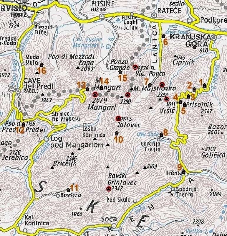
The detailed map. Red spots are summits, posted on SP.
Valley of Trenta is base starting-points for all routes on the Bavski Grintavec. It is approachable from Bovec or from Vrsic pass ( 1611m). On Vrsic you come from Kranjska Gora.
One of starting-point is secondary valley of Trenta called Zadnja Trenta. Here leads one of the easiest route to the summit of Bavski Grintavec. You drive by Koca pri Izviru Soce (Hute by the spring of Soca) where you can sleep and take a look on spring of Soca. You drive from hute a few kilomters on macadam road to the parking place on altitude 962 metres.
Second starting-point is village Soca in the valley Trenta. It is on altitude around 500 metres.
Third starting-point is in secondary valley of Trenta called Bavsica. You drive with car to the hute Mladinski center where you park. Here you can also sleep. The altitude is 701 metres.
Trenta is by many most beautiful and most romantic valley of Julian Alps. It is certainly one of longest (around 22km), placed in the heart of Julian Alps, dividing them into western and eastern part. Its mouth or end is near the small town of Bovec where it enters Bovec basin. Through it runs the most beautiful Slovenian river, crystal clear Soca! It has amazing light blue – light green color and is very popular for rafting. Along the river there are few villages and hamlets. Largest and most beautiful are Soca and Trenta villages.
Trenta is very deep valley. Some of the peaks rise 2000m above it. Trenta begins bellow beautiful Bavski Grintavec (2347m) peak. Its 5km long upper part, squeezed between Jalovec group and Trentski Pelc ridge is called Zadnja Trenta. This is wildest and most beautiful part of the valley. At the end of Zadnja Trenta, where valley begins to make 180 degree turn around Trentski pelc group is source of Soca river. It appears on the surface 100 meters above valley floor, coming out of deep hole filled with crystal clear blue water, surrounded by smooth and dark cliffs.
A kilometer lower, at bridge over Soca and Limarica rivers, Vrsic pass road begins to ascend. Few hundred meters up the road is famous monument to Julius Kugy which as ever looking at Jalovec. This is one of most beautiful panoramas in Julian Alps!
 |  |  |  |
Routes Overview
Some general possibilities are written:1. The easiest route goes up from Zadnja Trenta - Planina Zaplotok - then 2 possibilities: - Kanja preval (pass) then on N ridge and on top over hard feratta.
- On crossing where is going route to the Kanja preval (pass) go left to the upper route which leads you to the N ridge above the hardest problems in feratta.
- and on top.
2. In summer very hot route from village Soca over the south slopes to the summit. Altitude is very high: 1800 metres!
From Soca you lead marked route to the meadow Na Soco on altitude 1400m. Then follow the route to the top through the beautiful landscape. Just below the summit you must climb but not hard.
3. The first marked route starts in valley Bavscica where you park your car by Mladinski center hute. You go up to the meadow Bukovec and there turn right towards Bavski Grintavec. You come to the another crossing where you have two possibilities: - If you go to the left you come on the Kanja preval (pass) and up over the N ridge.
- If you turn right you come on SW ridge and to the top. I didn`t walk there but the road is marked and secured.
4. SKI tours from Bavski Grintavec and ravines. A lot of ravines have already been skiing. I named some ravines. The estimation of dificulty is for skiing.
and a lot of more...
 |  |  |
Red Tape
Bavski Grintavec is in Triglavski Narodni park.On the route from valley Zadnja Trenta you cross two forest reserves called Zapodnem and Apica. Apica includes a meadow Zaplotok which is meadow of butterflies and flowers. It is breathtaking!
When To Climb
In Summer (August) could be very hot specialy on the south side from village Soca soo it will be better if you go in June, July or September.In April, May you perhaps have problems with snowfields.
It`s nice if you go in May to the meadow Zaplotok and look all kinds of flowers and butterflies and enjoy of view to Srebrnjak, Bavski Grintavec and other mountains.
Camping
The camping in this are are not allowed because this is Triglavski Narodni park.Mountain Conditions
In Summer (August) could be very hot specialy on the south side from village Soca soo it will be better if you go in June, July or September.In April, May you perhaps have problems with snowfields.
It`s nice if you go in May to the meadow Zaplotok and look all kinds of flowers and butterflies and enjoy of view to Srebrnjak, Bavski Grintavec and other mountains.
 |