
|
|
List |
|---|---|
|
|
Welcome to Colorado's County Highpoints
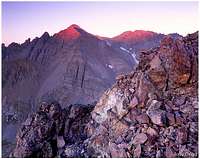
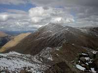
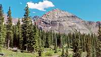
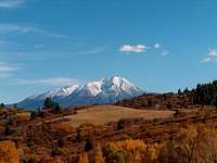
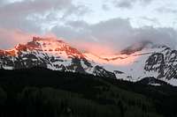 Vermilion Peak, San Juan County
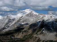
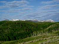
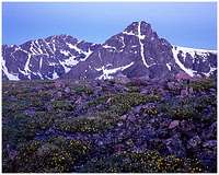
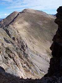 Pettingell Peak, Grand County
Colorado has 64 counties. Of these, 43 counties have mountains and 21 are on the plains. The plains counties include Denver, Colorado's state capitol. Climbing the county highpoints is an interesting and educational challenge, which offers a well-rounded sampling of the state's geography. All county high points may be climbed by a class 4 or easier route, putting all 64 highpoints within reach of the average climber. Several years ago I developed an interest in climbing all the mountainous county highpoints in my home state of Colorado. This goal has led me into a variety of hiking experiences, into many of the remote corners of the state. Each highpoint offers unique features and its own particular beauty, as well as unique mountaineering and orienteering challenges.
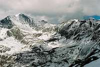
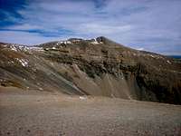
 Blanca Peak, three counties
The elevation of the highpoints in mountainous counties ranges from 9836' Thunder Butte in Douglas County, to 14,440' Mount Elbert in Lake County. In the plains counties, elevations are mostly below 6000', although Elbert County, east of Douglas County, reaches 7360'. As you would expect, several counties share highpoints in common.
Mountainous Counties
Mountains dominate the western two-thirds of Colorado. All the county highpoints are on mountains documented on SummitPost, though not necessarily on the summits of those mountains. The links in the list below will take you to the appropriate SummitPost page.
| County | High Point | Range | Elevation | Information |
| Alamosa | Blanca Peak | Sangre de Cristo | 14,345' | Three counties' high point |
| Archuleta | Summit Peak | San Juans | 13,300' | South San Juan Wilderness |
| Boulder | Longs Peak | Front Range | 14,259' | Rocky Mountain National Park |
| Chaffee | Mount Harvard | Sawatch | 14,420' | Third highest in Colorado |
| Clear Creek | Grays Peak | Front Range | 14,278' | Highest point on North American Continental Divide |
| Conejos | Conejos Peak | San Juans | 13,172' | Shares the county name |
| Costilla | Blanca Peak | Sangre de Cristo | 14,345' | Three counties' high point |
| Custer | East summit of Crestone Peak | Sangre de Cristo | 14,260' | East summit is 34' lower than west summit |
| Delta | Mount Lamborn | Elk | 11,396' | Gunnison National Forest |
| Dolores | Mount Wilson | San Juan | 14,250' | |
| Douglas | Thunder Butte | Front Range | 9,836' | Lowest mountainous highpoint. Site of Hayman Fire. |
| Eagle | Mount of the Holy Cross | Sawatch | 14,005' | Was once a National Monument |
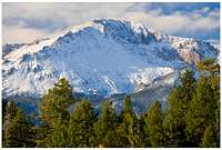
| El Paso | Pikes Peak | Front Range | 14,115' | Can reach the summit by foot, tramway, or car |
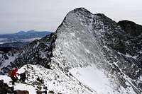
| Fremont | Bushnell Peak | Sangre de Cristo | 13,105' | Straddles the Saguache and Fremont county line |
| Garfield | Flat Top Mountain | Flat Tops | 12,354' | Flat Tops Wilderness |
| Gilpin | James Peak | Indian Peaks | 13,294' | James Peak Wilderness |
| Grand | Pettingell Peak | Front Range | 13,553' | on the Continental Divide just north of Eisenhower Tunnel |
| Gunnison | Castle Peak | Elk | 14,265' | High point for Pitkin County also. Southernmost 14er in Elk Range. |
| Hinsdale | Uncompahgre Peak | San Juan | 14,314' | Highest peak on Colorado's western slope |
| Huerfano | Blanca Peak | Sangre de Cristo | 14,345' | Huerfano County high point is slightly northeast of summit |
| Jackson | Clark Peak | Medicine Bow Mountains | 12,951' | Rawah Wilderness |
| Jefferson | Buffalo Peak | Kenosha | 11,589' | Lost Creek Wilderness |
| La Plata | Windom Peak | San Juan | 14,092' | Remote |
| Lake | Mount Elbert | Sawatch | 14,440' | Colorado state highpoint |
| Larimer | Hagues Peak | Mummy | 13,560' | Rocky Mountain National Park |
| Las Animas | West Spanish Peak | Sangre de Cristo | 13,626' | Spanish Peaks Wilderness |
| Mesa | Leon Peak | Grand Mesa | 11,236' | The summit features a 20th century abandoned fire lookout |
| Mineral | Phoenix Peak | San Juan | 13,895' | Also known as Gwynedd Mountain and Creede Crest. La Garita Wilderness. Near the Wheeler Geological Area. |
| Moffat | Black Mountain | Elkheads | 10,815' | Finding the true summit may be the biggest challenge. |
| Montezuma | Hesperus Mountain | La Plata | 13,232' | |
| Montrose | Castle Rock | San Juan | 11,453' | Highest one of 18 officially named Castle Rock's in Colorado |
| Ouray | Mount Sneffels | San Juan | 14,156' | Regarded by many as Colorado's most beautiful mountain. |
| Park | Mount Lincoln | Mosquito | 14,291' | |
| Pitkin | Castle Peak | Elk | 14,265' | High point for Gunnison County also. Southernmost 14er in Elk Range. |
| Pueblo | Greenhorn Mountain | Wet Mountains | 12,347' | Greenhorn Mountain Wilderness |
| Rio Blanco | Northwest arm of Orno Peak | Flat Tops | 12,027' | Two miles northwest of Orno Peak's summit |
| Rio Grande | Bennett Peak | San Juan | 13,203' | Walkup grassy slopes |
| Routt | Mount Zirkel | Park | 12,180' | Mount Zirkel Wilderness |
| Saguache | Crestone Peak | Sangre de Cristo | 14,294' | West summit of Crestone Peak |
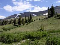
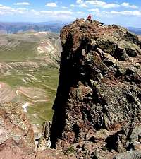
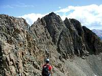
| San Juan | Vermilion Peak | San Juan | 13,894' | Least populated county |
| San Miguel | Wilson Peak | San Juan | 14,017' | Lizard Head Wilderness |
| Summit | Grays Peak | Front Range | 14,278' | Highest point on North American Continental Divide |
| Teller | Devil's Playground | Front Range | 13,060' | Also see Sentinel Point route |
Plains Counties
In eastern Colorado, the highpoints are subtle rises on the Great Plains, and sometimes not even that. However, at least one of these highpoints has its own page on SummitPost. Reaching these highpoints has little to do with mountaineering and everything to do with driving long distances over the plains, following directions, gaining access to land, and straining to discern the highest point. It is a rare and unusual person who can enjoy that, but more power to 'em!
| County | High Point | Elevation | Information |
| Adams | DIA Ridge | 5,665' | Easy drive up, exit I-70. |
| Arapahoe | Smoky Hill Ridge | 6,215' | No longer outside of town. |
| Baca | Carrizo Mountain | 5,280' | If you can find Carrizo Mountain, the highpoint is a small rise on the mesa top. No permission required. |
| Bent | San Jose Ranch Mesa | 4,855' | Permission and short uphill hike required. |
| Broomfield | Rocky Flats | 5,845' | SE corner of CO 128 and Indiana Street |
| Cheyenne | Bledsoe Ranch Road | 5,255' | Bledsoe Ranch. Permission and short hike required. |
| Crowley | Schubert Hill | 5,220' | Schubert Ranch. 2.5 mile hike. |
| Denver | Kipling & Belleview | 5,685' | Alley just east of Kipling, north of Jellison. |
| Elbert | Elbert Rock | 7,360' | Five areas, including two small rock outcrops, compete for the HP title. |
| Kiowa | Selenite Bluff | 4,690' | Davis Ranch. Near Lincoln County line. |
| Kit Carson | Bledsoe windmill | 5,290' | A mile or two from Cheyenne County highpoint. Both on private land. |
| Lincoln | County line rise | 5,960' | Drive up. Access permission not required. |
| Logan | State line bluffs | 4,940' | On ranchland owned by a private grazing association. Ask permission. |
| Morgan | Judson Hills | 4,935' | Private ranch; contact owner in advance. |
| Otero | Dry Bluff | 5,260' | Comanche National Grassland |
| Phillips | Phillips county line rise | 4,120' | 11 areas vy for HP honors. One of them is the lowest county HP in Colorado. |
| Prowers | Two Buttes | 4,711' | Twin peaks rise sharply from the plains, offering a rare climb in eastern Colorado. Private land. |
| Sedgwick | Sand Hills | 4,120' | Lowest county HP, along with Phillips County. Concrete block and a large stump marking the HP. |
| Washington | Presidents Hill | 5,420' | An imperceptible rise on a county line road. |
| Weld | Bison Butte | 6,385' | Guided nature walk is part of the bargain on the Terry Bison Ranch. |
| Yuma | Yuma corner | 4,445' | An imperceptible rise on a county line road. |
Colorado County Map

See full size map at get-direction.com.
External Resources
 James Peak, Gilpin County
Hiking Colorado's Summits (guidebook) www.cohp.org Colorado Counties lists of John
Honor Roll
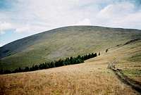
 Flat Top Mountain, Garfield County
Credit to cohp.org and peakbagger.com for this list of people who have touched all of Colorado's county highpoints. There may be many more.
 Bushnell Peak, Fremont County
Kevin Baker Layne Bracy John Collard Renata Collard Phil Congdon Beckie Covill Dave Covill Teresa Gergen Adam Helman Doug Hill Dawn Howard Kirk Mallory John Kirk Bob Martin John Mitchler S Mueller Dan Nielsen David Olson Gerry Roach Jennifer Roach Gary Swing Patrick Thornley G Vandersluis Charlie Winger Jobe Wymore
Gallery
A pictorial directory of the county highpoints...
 Bennett Peak, Rio Grande County
 Black Mountain, Moffat County
 Blanca Peak, Alamosa, Costilla, and Huerfano counties
 Buffalo Peak, Jefferson County
 Bushnell Peak, Fremont County
 Castle Peak, Gunnison and Pitkin counties
 Castle Rock, Montrose County
 Clark Peak, Jackson County
 Conejos Peak, Conejos County
 Crestone Peak, Custer and Saguache counties
 Devil's Playground, Teller County
 Mount Elbert, Lake County
 Flat Top Mountain, Garfield County
 Grays Peak, Clear Creek and Summit counties
 Greenhorn Mtn, Pueblo County
 Hagues Peak, Larimer County
 Mount Harvard, Chaffee County
 Hesperus Mountain, Montezuma County
 Mount of the Holy Cross, Eagle County
 James Peak, Gilpin County
 Mount Lamborn, Delta County
 Leon Peak, Mesa County
 Mount Lincoln, Park County
 Longs Peak, Boulder County
 Orno NW, Rio Blanco County
 Pettingell Peak, Grand County
 Phoenix Peak, Mineral County
 Pikes Peak, El Paso County
 Mount Sneffels, Ouray County
 Summit Peak, Archuleta County
 Thunder Butte, Douglas County
 Uncompahgre Peak, Hinsdale County
 Vermilion Peak, San Juan County
 West Spanish Peak, Las Animas County
 Wilson Peak, San Miguel County
 Mount Wilson, Dolores County
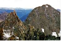 Windom Peak, La Plata County
 Mount Zirkel, Routt County
McCannster - Apr 3, 2011 9:17 pm - Voted 10/10
Prowers County HPJust made a page for the Prowers County HP, a plains high point, but hey, it's actually a hill! http://www.summitpost.org/two-buttes-prowers-county-hp/708071
Jeremy Hakes - Nov 17, 2011 10:01 am - Voted 10/10
BroomfieldActually, your map DOES include Broomfield on there... that little blob of existence. :)
bdloftin - Jul 30, 2020 1:17 pm - Hasn't voted
La Plata County High PointThe high point of La Plata county was surveyed and determined to be Windom Peak by a few feet. See notes in both linked sites: https://listsofjohn.com/peak/42 https://www.peakbagger.com/peak.aspx?pid=5861