
|
|
List |
|---|---|
|
|
What is a "Two-Fer" County Highpoint?
A well-written SummitPost page is already dedicated to USA County Highpoints in general. There are also well-written SummitPost pages dedicated to county highpoints in specific States. However, the intent of this SummitPost page is to define and display "two-fer" county highpoints only.One might ask what a "two-fer" county highpoint is. In simple terms, as defined by the County Highpointers Association, a "two-fer" is a county highpoint shared by two adjacent counties. In other words, a "two-fer" highpoint is located along a county line and is the highest point for the adjacent counties along that county line.
There are four types of two-fer county highpoints: True two-fers, near two-fers, partial two-fers, and trip two-fers. The first two types are closer to the definition of a "two-fer" than the latter two types.
True two-fers are those county highpoints that strictly follow the "two-fer" definition given above.
Near two-fers are two county highpoints that are located within 1/4-mile of each other on the same ridge.
Partial two-fers occur when counties share multiple possible highpoint candidates and at least one of those highpoint candidates is a true two-fer as defined above.
Trip two-fers occur when one county highpoint is typically located within a one-mile hike or five-mile drive/ride of the second county highpoint's route.
For county highpointers, two-fers present great opportunities to eliminate multiple county highpoints during singular trips. In a sense, summiting a two-fer is like getting double the reward with half the effort for a county highpointer.
For a national map showing each two-fer county highpoint location, please visit this link.
Is There Such A Thing As A "Three-Fer" County Highpoint?
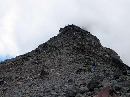
There is actually one so-called "three-fer" county highpoint in the United States: Blanca Peak in Colorado. Blanca Peak contains the highest point for three counties: Alamosa County, Costilla County, and Huerfano County. However, the peak is not a true three-fer in the sense that all three counties have their highest point at the summit. The summit of Blanca Peak is the highest point for both Alamosa County and Costilla County, and is a true two-fer in that regard, while the highest point for Huerfano County is located only a short distance from the summit along the northeast ridge of the mountain. Blanca Peak
Another near "three-fer" county highpoint, although to a lesser degree than Blanca Peak, is Mount Jefferson in Oregon. The summit of Mount Jefferson is the highest point in Jefferson County and Linn County. However, the highest point for neighboring Marion County is located on the north ridge of the mountain, nearly 1500' lower and 0.6 miles away from the summit. The Marion County Highpoint is a "liner" county highpoint, with no distinctly verified and/or officially distinguishable location of the exact highest point on the ridge. The Marion County Highpoint is considered a trip two-fer county highpoint, as it is located close enough to standard approaches for the Mount Jefferson summit to be a feasible addition to such trips.
 Marion County Highpoint
TRUE TWO-FERS
| STATE | COUNTY HIGHPOINT | COUNTIES |
| Alabama | Johnson Top | Madison, Jackson |
| Arkansas | Poteau Mountain | Scott, Sebastian |
| California | Mount Whitney | Inyo, Tulare |
| Colorado | Blanca Peak | Alamosa, Costilla |
| Colorado | Castle Peak | Gunnison, Pitkin |
| Colorado | Grays Peak | Clear Creek, Summit |
| Idaho | Meade Peak | Bear Lake, Caribou |
| Kentucky | Leesburg BM | Harrison, Scott |
| Kentucky & Virginia | Birch Gap | Dickenson, Pike |
| Montana | Edith Peak | Broadwater, Meagher |
| Montana | Snowshoe Peak | Lincoln, Sanders |
| New Mexico | Truchas Peak | Mora, Rio Arriba |
| North Carolina | Calloway Peak | Caldwell, Watauga |
| North Carolina & Tennessee | Clingmans Dome | Swain, Sevier |
| North Carolina & Tennessee | Roan High Knob | Mitchell, Carter |
| North Carolina | Standing Indian | Clay, Macon |
| Oregon | Mount Hood | Clackamas, Hood River |
| Oregon | Mount Jefferson | Jefferson, Linn |
| Oregon | South Sister | Deschutes, Lane |
| Oregon | Mount Thielsen | Douglas, Klamath |
| Pennsylvania | Big Mountain | Franklin, Fulton |
| Pennsylvania | Blue Mountain | Cumberland, Perry |
| Tennessee | Cross Mountain (The Flagpole) | Anderson, Campbell |
| Texas | Unnamed, 3000' Location | Hemphill, Wheeler |
| Utah | Delano Peak | Beaver, Piute |
| Utah | Eccentric BM | Daggett, Uintah |
| Utah | Thurston Peak (Francis BM) | Davis, Morgan |
| Virginia | Apple Orchard Mountain | Bedford, Botetourt |
| Virginia | Hawksbill Mountain | Madison, Page |
| Virginia | Rocky Mountain | Amherst, Rockbridge |
| Virginia | Mount Rogers | Grayson, Smyth |
| Washington | Mount Daniel | King, Kittitas |
| West Virginia | Ivy Knob | Raleigh, Wyoming |
| Wyoming | Cloud Peak | Big Horn, Johnson |
| Wyoming | Gannett Peak | Fremont, Sublette |
 Mount Daniel: HP of King & Kittitas Counties, Washington State
NEAR TWO-FERS
| STATE | COUNTY HIGHPOINT | COUNTIES |
| California | Snow Mountain (East) | Colusa, Lake |
| Colorado | Crestone Peak | Custer, Saguache |
| Georgia | Tray Mountain | Habersham, White |
| Georgia | Brasstown Bald | Towns, Union |
| Illinois | High Knob | Gallatin, Hardin |
| Kansas/Missouri | Unnamed 1150' and 1130' Locations | Cass, Miami |
| Kentucky | Pilot Rock | Christian, Todd |
| North Carolina & Virginia | Fisher Peak | Surry, Carroll |
| Vermont | Mount Mansfield | Chittenden, Lamoille |
| Wyoming | Medicine Bow Peak | Albany, Carbon |
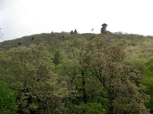 Brasstown Bald: HP of Towns & Union Counties, Georgia
PARTIAL TWO-FERS
| STATE | COUNTY HIGHPOINT | COUNTIES |
| Florida | Unnamed, 135' Location | Hardee, Manatee |
| Kentucky | Unnamed, 960' Location | Boone, Kenton |
| Kentucky | Unnamed, 1420' Location | Fleming and 1 of 3 Rowan |
| Maryland | Unnamed, 880' Location | Montgomery and 1 of 2 Howard |
| Missouri | Unnamed, 1480' Location | Taney and 1 of 8 Ozark |
| Nebraska | Unnamed, 2280' Location | Kearney and 1 of 2 Franklin |
| New Mexico | McKnight Mountain | Sierra and 1 of 2 Grant |
| Oklahoma | Unnamed, 1030' Location | 1 of 2 Nowata and 1 of 3 Washington |
| Tennessee | Flanigan Hill | Giles; 3 of 4 Maury |
| Tennessee | Unnamed, 2380' Location | Grundy; 1 of 2 Marion and 1 of 3 Sequatchie |
| Virginia | Unnamed, 1920' Location | Clarke, Loudon |
TRIP TWO-FERS
| STATE | COUNTY HIGHPOINT (IF NAMED) | COUNTY/COUNTIES | DISTANCE APART/CIRCUMSTANCE |
| Arkansas | Randolph, Sharp | 2 miles apart by vehicle | |
| California | Kern, Ventura | 2.5 miles apart by trail | |
| California | San Mateo, Santa Cruz | 5.5 miles apart | |
| Colorado | Cheyenne, Kit Carson | 1 mile apart on same ranch | |
| Colorado | San Miguel | 0.6 mile off Mt Wilson route (Dolores Co.). Plan on separate summit days. | |
| Colorado | Teller | 0.2 mile off Pikes Pk (El Paso Co.) toll road | |
| Florida | Collier, Hendry | 5 miles apart | |
| Florida | Okechobee | 4 spots within 5 miles of Indian River Co. | |
| Georgia | Polk | 0.2 mile off Flagpole Mtn route (Cherokee Co., Alabama) | |
| Georgia | Bald Mountain | Murray | 3.5 mile road and 0.4 mile hike off route to Fannin Co. |
| Georgia | Meriwether | 0.5 mile from Talbot Co. and 4 mile from Harris Co. | |
| Georgia | Pine Log Mountain | Cherokee | on route to Bartow Co. liner |
| Indiana | Fayette, Rush | 4 miles apart by vehicle | |
| Iowa | Buena Vista, Cherokee | 4.5 miles apart | |
| Iowa | Cerro Gordo, Hancock | 3 miles apart | |
| Iowa | Howard, Mitchell | 1 mile apart | |
| Iowa | Des Moines, Louisa | 4 miles apart | |
| Kansas | Bourbon, Neosho | 4.5 miles apart | |
| Kansas | Butler, Elk | 1.5 miles apart | |
| Kansas | Edwards, Pawnee | 4 miles apart | |
| Kansas | Osage, Shawnee | 3.5 miles apart | |
| Kansas | Osborne, Russell | 3 miles apart | |
| Louisiana | Catahoula, LaSalle | ||
| Maryland | Backbone Mountain | Garrett, Preston Co. (WV) | 1.2 miles apart by trail |
| Minnesota | Anoka, Isanti | 0.7 mile apart | |
| Minnesota | Blue Earth, Le Sueur | 1 mile apart | |
| Minnesota | Faribault, Freeborn | 1 mile apart | |
| Mississippi | Prentiss, Union | 0.75 mile apart on the same ridge | |
| Missouri | Audrain, Calloway, Boone | 1.7 miles apart; Boone 5 miles from both | |
| Missouri | Bollinger, Perry | 3 miles apart | |
| Missouri | Buchanan, Platte | 5 miles apart by vehicle | |
| Missouri | Carroll, Livingston | 2.0 miles apart | |
| Missouri | Clay, Ray | 3.5 miles apart | |
| Missouri | Dallas, Laclede | 2 miles apart | |
| Missouri | Linn, Macon | about 5 miles apart | |
| Nebraska | Gage, Johnson | 3 miles apart | |
| New Mexico | Lincoln | 0.5 mile off hike to Sierra Blanca (Otero Co.) | |
| New Mexico | Valencia | 1.5 miles west of Crest Trail to Torrance Co. from the north | |
| New York | Duchess, Litchfield (CT) | 0.7 mile apart (and 3 miles to Columbia Co) | |
| North Dakota | Kidder, Wells | 1.5 miles apart | |
| North Dakota | Sioux, Corson (SD) | 5 miles apart by vehicle | |
| Ohio | Miami, Shelby | 3 miles apart by vehicle | |
| Oklahoma | Cleveland, Oklahoma | 1 mile apart | |
| Oklahoma | Custer, Washita | 4 miles apart | |
| Oregon | Marion | 0.6 mile from Mt Jefferson summit (Linn and Jefferson Counties) | |
| Pennsylvania | Blue Knob - Schaefer Head | Bedford, Blair | 2.4 miles apart; 3.2 miles by road plus 0.9 mile hike |
| Pennsylvania | Fayette, Westmoreland | 1.8 miles apart | |
| South Dakota | Bruel, Charles Mix | 5 miles apart | |
| South Dakota | Deuel, Hamlin | 3.5 miles apart | |
| South Dakota | Douglas, Hutchinson | 3 miles apart | |
| South Dakota | McCook, Minnehaha | 2.6 miles apart, or 4 miles by road | |
| Tennessee | Old Black | Cocke | 0.2 mile off Mt Guyot route (Haywood Co., North Carolina) |
| Tennessee | Haw Knob | Monroe, Graham (NC) | trailheads 1 mile apart |
| Tennessee | Lincoln | one mile hike from Alabama two-fer of Madison/Jackson Counties | |
| Texas | Brown, Comanche | 4.7 miles apart | |
| Texas | Concho, Menard | 1 mile apart | |
| Texas | DeWitt, Karnes | 1.6 miles apart | |
| Texas | Gonzalez, LaVaca | 2.9 miles apart | |
| Texas | Grimes, Montgomery | 2.9 miles apart | |
| Texas | Jack, Young | 0.5 mile apart on the same ridge | |
| Texas | Jasper, Newton | 3.7 miles apart | |
| Texas | Parker, Wise | 4.7 miles apart | |
| Texas | Polk, Tyler | 2 miles apart | |
| Utah | Gilbert Peak | Summit | 1.3 miles off route to Kings Pk (Duchesne Co.). Plan on separate summit days. |
| Vermont | Signal and Butterfield Mtns | Caledonia, Orange | 1.6 miles apart with no trail |
| Vermont | Big Jay | Franklin | 1 mile off trail from Jay Pk (Orleans Co.) |
| Virginia | High Knob | Wise | less than 1 mile off routes to Norton City and Scott Co. |
| Virginia | Chestnut Knob | Bland | on route to Garden Mtn (Tazewell Co.) |
| Virginia | Fluvanna, Louisa | two miles apart | |
| Virginia | Poor Mountain | Montgomery | 3 miles by vehicle from Roanoke Co. |
| West Virginia | Marion, Taylor | 0.4 mile apart | |
| Wisconsin | Blue Mounds | Dane, Iowa | 2.5 miles apart, or 5 miles by road |