
|
|
Mountain/Rock |
|---|---|
|
|
38.89290°N / 113.0092°W |
|
|
Millard |
|
|
Hiking |
|
|
Spring, Summer, Fall, Winter |
|
|
7231 ft / 2204 m |
|
|

Overview
What a perfect name for a mountain range in Utah, the Cricket Range. I'm sure many of you know how crickets played a role in the early settling of Utah and how the seagulls saved the day. Or you might think Buddy Holly and the Crickets vacationed here or Jimminy Cricket was a resident before he moved to Hollywood to star with Walt Disney. Whatever the reason for the name, it doesn't change the fact that this is another of those out of the way and rarely visited summits in the western Utah desert.This peak is referred to as the Cricket Range HP so it is a rather generic type of name. At 7231' high, this peak is the highest one in the Cricket Mountain range even though this is no giant nor is it a particularly attractive summit.
Brushy trees cover much of the slopes and thus there isn't much that would attract anyone other than a prominence peak bagger. You see, this one has 2091 feet of prominence and that brings it in at a lowly #76 out of Utah's 81 prominence peaks that have at least 2000 feet of prominence. Very few of you reading this page will ever have a reason for venturing out here but just in case you do get the itch to see this part of Utah, I'll try to help you find your way to this peak. Its a fun little detour for those of you who are so inclined.
The state of Utah has designated much of the Cricket range for those who love to venture out on dirt roads on their off the road vehicles. See this LINK for a good map provided by the BLM.

Getting There
 Turnoff
 From Beaver Utah on I-15, turn off on Highway 21 and head for Milford. It is 30 miles from Beaver to Milford. In Milford, take 257 north towards Delta for 23 miles to a marked turnoff for the Cricket Mountains OHV area. A sign right at the entry of the road indicates 5 miles to Headlight Canyon and this is the road you want. At the fork that leads down to Headlight Gap, stay right on the road as it will continue on to Headlight Canyon. Overall it is about 11 miles from highway 257 to where you want to park your vehicle. A high clearance vehicle is best although a carefully driven passenger vehicle could most likely make it in the 11 miles o.k. I found a spot off of the road to park and then went cross country up towards the peak. (see map)
Note:
A shorter way to get to the turnoff on highway 257 if you are coming from Salt Lake City is to take highway 132 from Nephi. At Lyndyll, take U.S. 6
to Delta and about 5 miles west of Delta take highway 257 as it heads south for Milford. About 43 miles later, watch for MP 23 and the Headlight Canyon turnoff. This route will save someone coming from SLC a lot of miles.
The hike and the route
There is no trail but it is easy cross country. My GPS indicated it was only 3 miles round trip and about 1100 feet of elevation gain. I was up and back in two hours and that included a stay on the summit where I signed into the register. This peak sees very few visitors. The register was placed by John Vitz in 2001 and the next entry was made by a couple from California in 2004.The next visitors were our summitpost members Greg and Kadee in March 2008 and then a trio from Arizona in May of 2008. With my visit, 2008 has been the most active year for peak visitors. The views from the top are really worth the hike as you look down on the dry salt flats of Sevier Lake. I have attached a map to this page which will show the route I used to get up but on the way down I cut more directly downhill as I headed back to my vehicle.
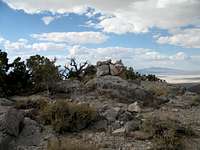
I found no benchmark on top this peak and the register is tucked inside the large rock cairn that adorns the highest spot.

Summit visitors


Both peakbagger.com and Lists of John indicate on their summit logs that about 18-20 people have visited this one. If you go to peakbagger, you will find several trip reports and some GPS tracks provided by some of those who have made the effort to visit this one. For example, Kay Komuro has a link to her photos from her visit.
Eric Willhite also has a webpage trip report you can find HERE.
Red Tape
This is BLM land and no permit is required. Stay on the marked roads and avoid driving off road. Be sure to have adequate water and a dependable vehicle as during the week you may see no one at all.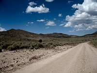 BLM road
Cedar City Field Office
176 East D.L. Sargent Drive
Cedar City, Utah 84720
(435) 865-3053
 The top
Camping
No organized campgrounds are in this area but you can car camp on BLM land. Please do not make new fire rings and pack out your garbage. A campground can be found at Minersville Reservoir, located between Beaver and Milfordand my wife and I found nice accomodations at the Oak Tree Inn motel in Milford. This motel is found at the west edge of town on highway 21. We spent two nights there and were happy with the room. The price included a complete breakfast for two people.
Beaver has several good motels and plenty of places to eat.
Weather

My trip report
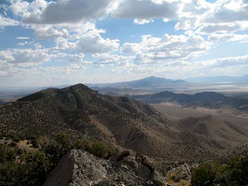
 The view towards Notch and Swasey Peaks
My wife and I left Lehi about ten a.m. and headed south on I-15. The easiest way to get to the turnoff that leads into the Cricket Mountains is via Beaver as mentioned in the section above. Another route you can take is to turn off at Nephi and head for Delta Utah. About 5 miles west of Delta is state highway 257 with a sign that says "Milford 70 miles". It is 47 miles to the turnoff near MP 23 but this way (via Nephi) is shorter than going through Beaver should you be interested in going this way.
In Delta we gassed up and had a quick lunch at McDonalds and made our way as described to the Headlight Canyon turnoff. The first section of the dirt road was very decent and when we came to the junction of BLM 1 and 2, we turned north onto BLM 2 and found it to be a rougher road although probably ok in most passenger vehicles if you have decent clearance. 4wd is not necessary but I wouldn't drive that road in rainy weather or with snow on the ground.
I had GPS'd where I thought it would be the best spot to park and start the hike from (see map) and when I arrived at that point, I noted that my odometer registered close to 11 miles from the pavement of 257.
The temperature was 84 degrees so I packed in an extra quart of water even though I knew the hike wouldn't be a long one. Still, I have run out of water before when I didn't expect to and on a hot day, it really sucks.
My wife remained in the truck while I started off but we kept in contact via handy talkies. The route I took headed up the side of a knob and dipped a bit into a ravine like depression before starting back up and heading for the saddle. I actually didn't go to the waypointed saddle as I found the terrain easy enough to just contour over towards the top and
I was glad to find no underbrush to deal with nor any rattlesnakes. There were plenty of scrubby trees and I just worked my way through them and eventually had the full summit in my view. When I arrived at the summit area, I found a large cairn atop the rock which was the highest spot and tucked inside the cairn was a glass bottle containing a register with just a few names in it. John Vitz had placed a register in 2001 and Gordon and Barbara from the Simi Valley replaced it in 2004. The next signees were
SP members Greg and Kadee, then three friends I hiked with just a couple days later on George Hansen and Graham Peaks and then myself. Very little visitation in the past 7 years but this peak would really only interest
someone who was interested in a prominence peak.
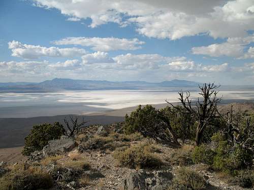
The views southwest were outstanding as Notch and Swasey peaks were obvious above the whitish Sevier Lake, which when dry is a salt flat.
Views northeast to Frisco Peak and the Wah Wah's were nice too but I
only spent about ten minutes on top before heading back to my wife who was
waiting in the heat and dealing with some irritating flies. The descent was quick and soon I was back at the truck, ready to head on down the road
to Milford, where we would spend the night.
This hike is quick and easy but it is sure isolated. We saw no one else during the time we were in the area but with the area being designated
as an OHV area, that must surely change on the weekends.
About Milford
Milford is the nearest town of any size and a good place to get gas and supplies. It has a population of about 1400 people and more information can be found at Wikipedia.Cell phone coverage is limited or non existent in the Cricket Mountain Range area. I have AT&T and could get no signals, not even in Milford. Other cell services may be O.K. in Milford but be forewarned. There are two gas stations in town and a grocery store a few blocks north on highway 257 (just beyond the center of town where highway 21 turns west)
 Frisco Peak and the Wah Wah's in the distance
Sevier Lake and future additions
Here's a couple links to this interesting "Lake".Link
As I update this page from time to time, I may add information about the area in this section.
As of September 2015 I have not found anything new to add. Google Sevier Lake and you may get newly added information about this area.
Realize that this area is very isolated and during the weekdays does not have many visitors. (see disclaimer below) Go prepared with a vehicle in good shape, plenty of gas and water and a spare tire or two. Do not expect cell coverage or readily available help if you have problems of any kind. Despite the fact that this is one of the states OHV areas, traffic is minimal during the summer and winter months.
Disclaimer
Hiking, climbing or traveling in this type of country can be inherently dangerous, the above information is provided only as a courtesy. You accept all risk and responsibility for your activities in this area and I recommend that you let others know of your plans and where you will be hiking/climbing prior to heading to this area. Be self sufficient and carry plenty of food, water and shelter in the event of a breakdown. Good quality tires are a necessity on the rough and rocky roads you will encounter as is a vehicle in good condition. Roads may become impassable when wet. Avoid the area during electrical storms and avoid high ridges &exposed areas. Having said all that, have a good trip and please let the author of this page know of changes that you encounter.Please let me know if road conditions or access changes.