
-
 5512 Hits
-
 90.34% Score
-
 32 Votes
|
|
Mountain/Rock |
|---|---|
|
|
47.36107°N / 11.35579°E |
|
|
Hiking, Big Wall |
|
|
Spring, Summer, Fall, Winter |
|
|
8176 ft / 2492 m |
|
|
Overview
 Hoher Gleiersch from the valley floor.
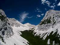
Hoher Gleiersch (or Hochgleiersch as it is sometimes called) is the westernmost prominent mountain of the Gleiersch-Halltal chain of the Karwendel. Its strange name comes from romanic "glarea" which simply means scree and well Hoher Gleiersch has a lot of that on its south side. The north side is a sheer drop of about 600m/2000ft down to the Hinterautal. From the top you have a breath-taking panorama of Karwendel' s main ridge to the north. The south offers splendid views of the glaciated mountains south of the Inn-valley.
Since Hoher Gleiersch is a mountain close to the heart of Karwendel it offers everything Karwendel stands for.
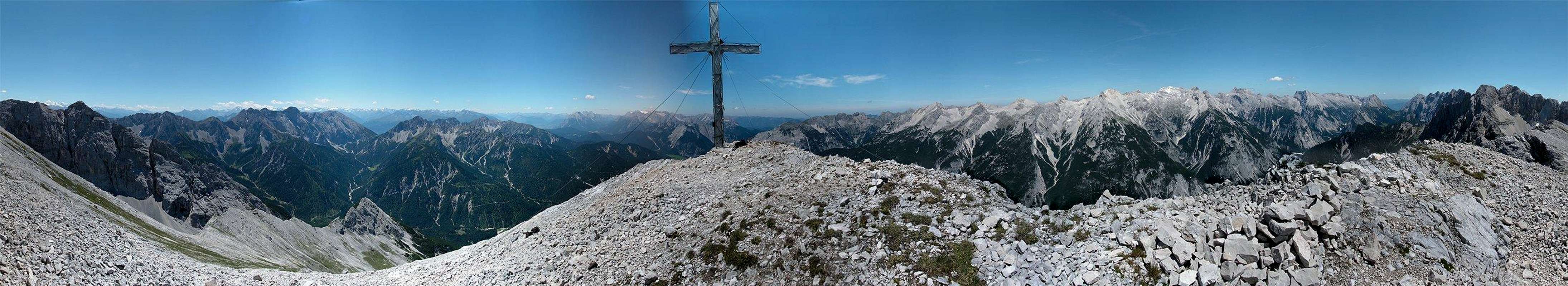
 Beautiful views from the top.
Starting at Scharnitz (964m/3163ft), there are two popular routes along the south and north-west ridge leading up to the summit of Hoher Gleiersch. While the trail along the south ridge is marked quite well and you don' t have problems finding your way, you' ll have to search for your path along the north-west ridge. The KOMPASS map 26 - Karwendelgebirge shows a ski-route along the north-west ridge, but I don' t think Hohe Gleiersch is visited often in winter since the upper slopes are very steep. The impressive north walls of Hoher Gleiersch offer several climbing routes.
Maps and routes overview
 South slopes.
Maps:
- KOMPASS #26 - Karwendelgebirge
Good overview map of the hole Karwendel. For hiking porpuses this map is sufficient (scale 1:50000). The map can be bought at www.amazon.de or at KOMPASS. - Alpenvereinskarte 5/1 Karwendelgebirge, West
More detailed map (1:25000) of the western part of Karwendel
 Gleirscher Riegelkar
Routes:
There are only two popular routes up to Hoher Gleiersch. Both of them lead along the steep southern slopes. The north face of Hoher Gleiersch offers several climbing routes.
- North west ridge (ski-route)
Starting in Scharnitz you have to follow trail #221 into the Gleiersch-valley until you reach a four-way crossing. Turn left onto the unmarked forrset road and follow it until it ends (look out for the shurtcut visible on the map!). Now you have to ascend the south slope until you reach the ridge which leads to the summit. - Via Amtssäge
Follow trail #221 until you reach the alp Amtssäge. Shortly behind the hut a trail leads up to Hoher Gleiersch. Don' t bother with the blocked fence-door and simply climb over it (I' ve tried a while to open it). If you intend to use your bike to get to Amtssäge I suggest taking trail #57 instead of #221. You' ll have to do some extra meters to ascend but after this short section you mostly roll for several kilometers until you reach to four-way crossing mentioned above.
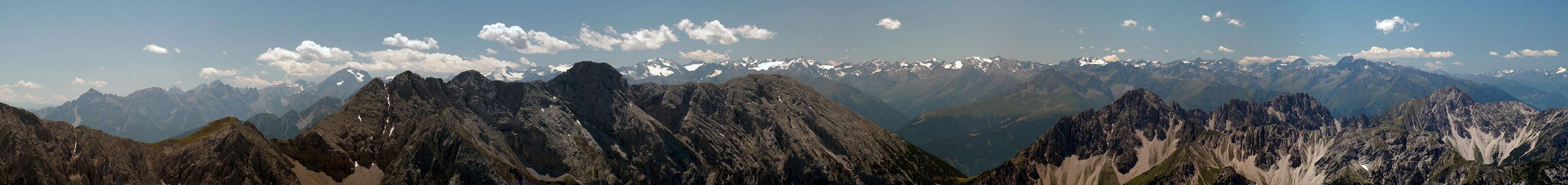
Panoramic views
  |
 |
Getting There
 Scharnitz
| By car: | To reach the trailhead, you have to drive to the city of Scharnitz at the Austrian/German border. Road 177 and B2 which connects Innsbruck (Austria) and Garmisch-Partenkirchen (Germany) runs through Scharnitz. From Garmisch-Partenkirchen you have a highway connection to Munich and Innsbruck provides a conenction to Italy (Brenner). After reaching Scharnitz you' ll have to drive to the parkinglot of the Karwendel (watch for the signs close to the bridge at Scharnitz). |
| By train: | If you go to Hoher Gleiersch by train your trailhead is the train station at Scharnitz. About every hour the train from Garmisch-Partenkirchen (Germany) to Innsburck (Austria) stops there. From Garmisch-Partenkirchen you have access to the trains to Munich, Ehrwald (Austria) and Rheutte (Austria). Innsbruck is the gateway to Italy (Bozen/Bolzano, Verona). For more information visit the homepage of Deutsche Bahn for german and ÖBB for austrian train connections. There are sign at the train station leading to the trails leading into the Karwendel. |
Mountain conditions
Weather:
- www.wetter.com
Precise, but sometimes inaccurate weather forecast for the city of Scharnitz. - ZAMG
Not as detailed as the link above, but quite accurate forecasts. - OEAV weather forecast
Weather forecast especially for mountaineering porpuses. Unfortunately this page is available in german only. - Avalanche report (Tyrol/Austria)
As noted before, this german internet page offers the current avalanche report for Tyrol.
Webcams:
 | Webcam at Seefeld looking up to Ross-hut (1751m/5745ft), about 10km from Hoher Gleiersch. |
Red Tape
 Butterfly on the summit
There are no permits, fees or seasonal closures.
There is a parking at the beginning of the Karwendel which isn' t free for sure, but I have no information about prices.
Hoher Gleiersch is part of the nature reservation area Karwendel and therefore it is forbidden to camp on the mountain. Additionally you shouldn' t pick up flowers and don' t leave anything but footprints.
Camping
The area around Scharnitz is very touristic with tons of hotels and places to stay. For more information visit the multilangual homepage of the area of Seefeld. Innsbruck and Garmisch-Partenkirchen aren' t far away as well.
Because of the nature reservation area Karwendel, camping on the mountain is forbidden. Additionally you should carry everything back down with you and leave only footprints. There are no real huts close to the mountain. There are two alps at the bottom of the mountain (Amtssäge and M&oulm;slalm/Arzler Kristenalm), but I don' t know if they offer overnight stays.
Page history
| 25/Nov/2007 |
|