
-
 15231 Hits
-
 79.24% Score
-
 11 Votes
|
|
Mountain/Rock |
|---|---|
|
|
47.39068°N / 11.50131°E |
|
|
8474 ft / 2583 m |
|
|
Overview
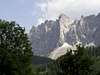
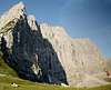
The Karwendel central chain (Hinterautal - Vomper chain) spreads from Birkkarspize in the west to Lamsenspitze in the east.The central part of this chain between Laliderer Spize and Grubenkar Spitze features an impressive north face, several kilometers wide and almost 1000 m high.
The Laliderer Spitze is the peak crowning this wall., with a dominant position over Spielissjoch and Falken Hut in the north. On this side, the easiest ascent route is the Herzog Kante (Herzog edge UIAA IV-V).
From the south, the access is more easy . This route for (very) experienced hikers through the Rossloch is very long : there is no hut in the Hinterautal and the best solution is to use a mountain bike to the start of this route.
 |  |  |  |  |
Getting There
The Karwendel can easily be reached by car, train and even airplane. From Innsbruck there are regular trains to Munich (2-3 hrs, either directly or via Mittenwald, Scharnitz and Seefeld) and Vienna. Planes fly into Innsbruck which connects to several European cities. Coming by train is best, as you are visiting a nature reserve (We want to keep the nature that we can visit, don't we?). The train will bring you to most places on the south, east and west border: Aachenkirch, Schwaz, Innsbruck, Seefeld, Scharnitz and Mittenwald. These are all common places to enter the Karwendel.1) Start point to the south side : Scharnitz between Mittenwald and Innsbruck, train station (2 hours from Munich). From Scharnitz, follow the Hinterautal to Kasten Alm and Rossloch.
2) Start point to the north side : Scharnitz or Hinterriss
- From Scharnitz, follow the Karwendel valley to Karwendel Hut and Falken Hut
- From Hinterriss to Falkenhut over Johannestal, Laliderertal or Engtal. To Eng (Grosser Ahornboden) bus line from Lenggries over Hinterriss.
 |
Red Tape
Karvendel is a natural reserve.With its 54325ha (134182 acres) the Karwendel is Austria's largest nature reserve. Even larger than the famous 'hohe tauern' which contains the high parts of Austria (like the Zillertaler Alps). Because it is lower in altitude and also not spread over several smaller areas, it also contains more variety than other reserves making the Karwendel unique.
Mountain biking
Many trails are passable for mountain bikes, certainly in the lower valleys. For hikers mountain bikes may be risky as some of them tend to descend very quickly. However mostly the lower parts of the Karwendel are shared between them. On the higher trails biking is risky as the slopes are very steep and the trails narrow. Most cabins can be reached by mountain bike. The Karwendelhaus and Hallerangerhaus are often visited by mountain bikers.
When To Climb
Summer season: July to octoberRoutes overview
1) Normal route from the south* Scharnitz (964 m) - Kasten (1220 m): 260 meters gradient 1:00 (with a mountain bike)
* Kasten - Roßloch (1430 m): 0:30 (mountain bike) - 1:00
* Roßloch - Laliderer Spitze (2583 m): 1130 meters gradient, 3:30
* Laliderer Spitze - Roßloch: 1130 m down, 2:00
* Roßloch - Kasten - Scharnitz: 470 m down 1:30 (mountain bike)
2) Herzog edge (Herzogenkante)
3) North face direct (climbing report in german)
4) Schmid Krebs route (climbing report in german). Read also the section climbing history (the rescue)
5) Roping down route ; begins just under the summit : Spindlerschlucht, and leads to Falken Hut.
 |  |  |  |  |
Huts
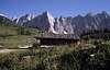
- Falken Hut 1846 mThe Laliderer wall arises above it, making this old cabin look smaller than it is. Heavily visited from the Engalm but most of these people leave in the afternoon.
sleeping places: 28/136/-, winter room: 11
reachable from: Hinterriss (3,5) Eng-alm (2-3)
- Karwendel Hut 1765 m
Largest cabin in the area, holds almost 200 sleeping places!
Here you can take a hot shower and even pay with credit card.
sleeping places: 45/150/-, winter room: 26
reachable from: Scharnitz (5) Hinterriss (4)
- Posthotel, Hinteriss
Simple and sufficient hotel in this nice and very small town
 |  |
Camping
Camping not allowed, but a necessary overnight bivy is ok. There is a bivy shelter just some 100 m below the summit (no water !) : Karl Schuster Biwak. | 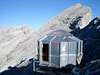 |
Mountain Conditions
Weather in SeefeldAlways remember that the Karwendel is part of the limestone alps and therefore the rock breaks very easily. A hook that may seem secure may come loose unexpectedly, when force is applied in special way. Also rocks may come loose when stepped upon by the climber in front of you. This killed a climber in 1994. Many experienced climbers fail ascents in the Karwendel.
Maps
KompassGPS 4026 Karwendelgebirge
ISBN: 3-85491-253-6
Alpen vereins karten 5/1, 5/2 and 5/3 1:25.000 , Karwendelgebirge west, mitte, ost.
Alpen vereins karte 1:50.000 31/5 Innsbruck und Umgebung. Good for the easier (lower) trails, but not only for the Karwendel.
Freytag and Bernt 323, 1:50.000 Karwendelgebirge, gives a good overview of the whole area. Do not use it for high tours however as it gives a very poor indication on steepness of the trails.
Climbing history
- First climber : unknown- Herrmann Von Barth climbed during the summer 1870 on 88 summits in the Karwendel. He was the first explorer of the massif.
- N face direct first climb : Mathias Rebitsch with Franz Lorenz (1947)
- Biography of Mathias Rebisch (in german)
- Herrmann Buhl opened a lot of new routes in the north face.
- The Rescue
One of the most thrilling rescues in the Karwendel is the rescue of two German climbers in June 1979 on the 900mtrs high Lalidererwand. It is a story told over and over and shows the Karwendel has, beside its friendly appearance, also a dangerous character.
On 15 June 1979, Wolfgang Grunenberg and Hubert Wehrs planned to climb the Lalidererwand via the popular Schmid-Krebs-Route. In June there is still a lot of snow in the shadow areas, specially on the north side, making the climb the two Germans tried more risky than it would have been in August or September. Also the weather did not look good, as it often is in June. Cumulus clouds drift slowly over the Karwendel and also the radio-forecast was not good. But both were experienced climbers and trusted their skills. Also they carried a sleeping-bag, just in case. The tour is indicated as being 7-12 hours (but also done in 5) and on top there is a small cabin for shelter during the night. So they hooked together and started the climb. At first all goes well, the chimney and the Krebsrisse (IV), the most risky parts, are taken without taken without trouble although drops of rain are felt. At the Pfeilerkopf, it's 2 o'clock, and they decide to wait and see how the weather turns out. Soon it is pouring with rain and lightning shoots through the air, followed by mighty echoing thunders. In these conditions the Lalidererwand becomes alive and hell on earth. Streams and stones come down everywhere. Around 6 o'clock in the evening they realize they are trapped and start shouting for help, 6 times a minute according alpine emergency signals. Slowly the rain turns into snow. More by co-incidence, they are heard by someone in front of the Falkenhutte. He warns the huttenwirt (hut warden), who was by good custom informed by the two climbers about their tour, so he knows they are on the Schmid-Krebs-route as no other climbers were present. And he also knows what it is like when the Lalidererwand becomes alive. He sends out an alarm to the berg-rescue group in Seefeld. In the same night a rescue team is assembled. As an helicopter cannot be used in these conditions, they are driven to Kastenalm in the Hinterautal. From this side the climb to the cabin is much easier and can be done in 5 hours when the conditions are good. But these man have to travel in awesome weather, through fresh snow and with the burden of the rescue materials. They carry two 800mtr steel cables, each weighing 100kg! Also two 100mtr cables as the Lalidererwand is 900mtrs high. For rescues in the Karwendel 800mtr cables are specially made as the Karwendel has many high walls. In those cases connected cables tend to get stuck between rocks and won't move up or down. In the afternoon the rescue team reaches the edge, wet to the skin and exhausted. However they immediately try to get a fix for the cable, which is difficult on the edge as it mainly consists of loose rocks. Using more cables, fixed on several places, they are finally ready to start the descent. Fritz Popella goes down first, the weather is still the same, with clouds hanging against the Lalidererwand giving rain and snow. Visibility is almost zero. There is no answer to their calls, the Lalidererwand seems to absorb them. Halfway down the wall Fritz gives the sign to take him up again as he did not see or hear anything. It takes three hours to get him up. Next, more to the east, Otto Neuhauser goes down. He goes down further but the only responses he gets from his cries are the sounds of stones and water coming down. As the people on the edge are too tired to get him up in due time, Otto Neuhauser decides to descend further to the Falkenhutte, depressed. The man on the top cannot get the cable up again and it becomes useless for further attempts. They go to the cabin for the night. Without this cabin, which has nine sleeping places with blankets, the rescue attempt would not have been possible. The two climbers have to stay another night on the Lalidererwand, without real protection against rain and cold. As this rescue attempt has failed, a second team is assembled, with a third 800mtr cable, and they are on their way. It is still raining and snowing and they have to get to the edge in the same conditions as the first group. The Lalidererwand now is covered with snow and ice and frightens even the most experienced climbers. When the second team arrives another try by the first team has failed and the second cable is lost as well. The second team holds Laliderer expert Walter Spitsensatter. He immediately sees that the first group was too far to the west as they did not know the exact path of the Schmid-Krebs-route. He determines the point for the next try. At that moment on some places there was 3 meters of new snow! When Walter Spitsensatter descends he has to cut ice from the wall to prevent it cutting the cable and breaking loose, with him below. 200mtrs down he is unsure, is he still too far to the west? Visibility is less than 50 meters, so orientation, even for an experienced climber its extremely difficult, if not impossible. He uses rocks to get more to the east. Sometimes he suddenly falls 2-3 meters when the cables get loose from a rock. When he yells he only gets the echo from the wall. When it is 7 o'clock in the evening, Walter Spitsensatter hears a sound that does not seem to come from the wall. He goes more east and yells again. Then the answer comes! Walter now can see the red sleeping bag. He has found them! But he is now 50mtrs too far east, now cursing his decision to go more east. If he had not gone east, he would have come exactly to the right spot. He starts giving directions to the two so they can meet. He will descend and go more west, and they should descend and go more east. Soon he sees it is of no use. The two are not able to get closer to him and he can not reach them. Then it is 8pm, and too late for another try. "Can you hold on another night." he yells to them. "Yes, we can." is the reply from Grunenberg. Walter Spitzensatter descends to the Falkenhutte, remembering a tragedy on the North Wall of the Eiger in similar conditions. Then, the climbers were dead the next day. In the Falkenhutte he hears that the people on the edge could not get the third cable up and it was lost as well. Three days after the two climbers got into trouble, the fourth cable is brought up, and still it is raining and snowing. Now Klaus Hoi and Werner Sucher descend with a new system. They have 40mtr climbing cable connected to the steel cable. Therefore they are much more free than the earlier rescuers. After two hours they reach Wolfgang Grunenberg and Hubert Wehrs. Both are completely exhausted. They are fixed to the steel cable and the descent to the bottom starts. At 3pm they reach the bottom. Hubert Wehrs is too exhausted to walk and has to be carried to the Falkenhutte. The largest rescue operation in the Karwendel had a happy ending. Over 200 people participated in this rescue.
External Links
- Steinmandl.de
Route description and pictures (in German)
- http://ulrichprinz.de/alpin/at/laliderer
My climbing report of the "Direkte Nordwand