
-
 6324 Hits
-
 84.27% Score
-
 18 Votes
|
|
Mountain/Rock |
|---|---|
|
|
47.37653°N / 11.55899°E |
|
|
Mountaineering, Trad Climbing, Scrambling |
|
|
Summer, Fall |
|
|
8573 ft / 2613 m |
|
|
Overview
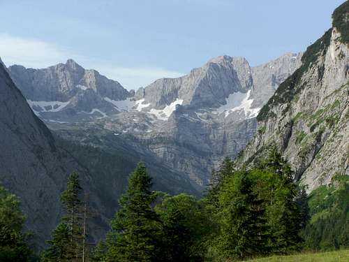 Eiskarlspitze (right) as seen from Eng valley
The - in my opinion - most impressive valley of Karwendel range is the Eng valley. Most Karwendels main valleys are west - east orientated. Eng valley has a more north - south orientation and ends after about 25 km, enclosed by impressive rockfaces and high peaks. The world gets narrow - eng in German - and that is why this valley got that name.
Eng valley belongs to Austria / Tirol but is a dead-end valley accessible by car or bus only from Germany. The connection to Achensee region or to Inntal valley can be made only via high and alpine notches or via cols with forest roads, closed to public traffic.
On the down side: there is a toll road going to the very end of that valley which means: many, many people in summer and early autumn. The toll road is closed in late autumn, winter and spring. Especially in autumn and spring, when the snow is gone, you will find many mountain bikers heading to the valleys end.
On the up side: There are many hikes to mountain huts, summits, many bike routes and many climbing routes starting from Eng valley. You can stay two weeks without being able to finish with all the possibilities this valley provides for you. And the best is: most hikes and peaks are not very crowded as most people stay in the valley or just hike from mountain hut to mountain hut, bypassing all those beautiful and sometimes challenging Karwendel summits.
One of those summits blocking Eng valley to the south and showing impressive rockfaces is Eiskarlspitze, the “peak of the ice cirques”. There are in fact two high cirques with normally everlasting snow fields, fed by snowdrift and avalanches in winter and spring. A name that fits.
Eiskarlspitze is in the eastern part of the nearly 15 km long main Karwendel ridge, running from Pleisenspitze near Scharnitz to Birkarspitze - highest peak of Karwendel - to Lamsenspitze and Hochnisslspitze in the east. Located between Spritzkarspitze (west) and Hochglück (east), Eiskarlspitze shows a steep and impressive rockface down to Eng valley and an endless rock slope to the south (Vomper Loch).
East of the peak there is a huge cirque with many karst features, called Hochglückkar, which is located some 400 m above Eng valley. West of Hochglückkar are located the Eiskarln, the cirques with the snow- and icefields which gave the name for Eiskarlspitze.
Eiskarlspitze was first summited by Hermann von Barth, July, 16th, 1870.
Eiskarlspitze is my favorite mountain in Eng valley. It is among the highest peaks of the region, provides a very interesting normal route, is not very well known and an impressive viewpoint. Besides my companions I never met more than one other party during my ascents, most times we were simply alone.
 Eiskarlspitze and Eiskarl waterfall Eiskarlspitze and Eiskarl waterfall |  Hochglückkar with Hochglück notches Hochglückkar with Hochglück notches |
Getting There
 At Hochglückscharte during Eiskarlspitze ascent
Main trailhead is Engalmen at the end of Eng valley.
You reach Eng valley by car
You can reach Eng valley from Munich by rail and bus, too. Check this possibility here.
The southern ascent via Vomper Loch to Eiskarlspitze is not done very often. You reach Vomp
Route Overview
 Eiskarlspitze summit ridge
There are several routes to Eiskarlspitze, all of them require at least mastering UIAA grade II and more.
Main mountaineer routes are:
- East ridge route: Eng or Lamsenjochhütte - Hochglückkar - Westliche Hochglückscharte - east ridge; grade II scramble - normal route
- Eiskarln route: Eng - lower Hochglückkar - traverse to Eiskarln - northwest ridge; grade III climb, bad rock, difficult route finding
- Ödkarl route: grade III- epic, south ascent, difficult to find
- traverse to Spritzkarspitze; grade III climb, can be combined to a loop with Hochglückkar route and Eiskarl route
Eiskarlspitze hosts some interesting climbing routes, too.
- North arete: UIAA grade IV
- Northern rockface from eastern Eiskarl: grade IV
- Northern rockface: Hand Georg Brendel Gedenkweg: grade VIII-
For more detailed information please refer to:
Bernd Eberle, Peter Mair, Mike Rutter, und Ralf Sussmann
Kletterführer Karwendel: Alpine Ziele & Klettergärten incl. Martinswand
Panico Alpinverlag
1. june 2004
Red Tape & Accommodation
 Eng Almen, main trailhead
Red Tape
Eng valley and Eiskarlspitze are part of the “Alpenpark Karwendel”, an important and strictly protected national park.
There is no entrance fee for the park but many regulations to follow.
There is a National Park Information Center at Hinterriß. Information panels, starting at the parking area of Engalmen, show some interesting features of the Alpenpark Karwendel.
Accommodation
Camping is not allowed within Alpenpark Karwendel.
Motorhomes and caravans are tolerated at the parking area of Engalmen.
Food and lodging can be fount at
Mountain hut
Gear & Mountain Condition
 Eiskarlspitze as seen from Hochglück
Eiskarlspitze is mainly a summer and autumn summit. Normally the routes are open by end of june. Huge corniches can block the north side traverses on the east ridge.
However a spring ascent can be possible in combination with a ski tour to Hochglückscharte. The summit register shows east ridge ascents in april and may as well. It depends on the snow situation and the skills of the mountaineer if that can be done successfully.
The east ridge requires UIAA grade II scramble in parts; belaying is difficult (many slabs, no fixed bolts) but in parts possible. A spring ascent should be more difficult.
The Eiskarln route is a UIAA grade III climb (in parts) in mostly bad and loose rock.
Both routes may need crampons and ice axe because of steep and hard to icy snow fields.
Current Weather:
Maps & Guide Books
 Evening at Hochglückkar
Guide Books
Heinrich Klier, Fritz März, und Walter Klier
Karwendelgebirge. Alpenvereinsführer alpin: Ein Führer für Täler, Hütten und Berge. Verfaßt nach den Richtlinien der UIAA
Bergverlag Rother
2005
Bernd Eberle, Peter Mair, Mike Rutter, und Ralf Sussmann
Kletterführer Karwendel: Alpine Ziele & Klettergärten incl. Martinswand
Panico Alpinverlag
1. june 2004
Maps
Alpenvereinskarte
Karwendelgebirge, Mitte
Scale 1 : 25.000
Deutscher Alpenverein
February 2008
Alpenvereinskarte
Karwendelgebirge, Ost
Scale 1 : 25.000
Deutscher Alpenverein
December 2005