
-
 49544 Hits
-
 87.76% Score
-
 25 Votes
|
|
Mountain/Rock |
|---|---|
|
|
39.61700°N / 105.66°W |
|
|
13602 ft / 4146 m |
|
|
Mount Evans Wilderness Overview
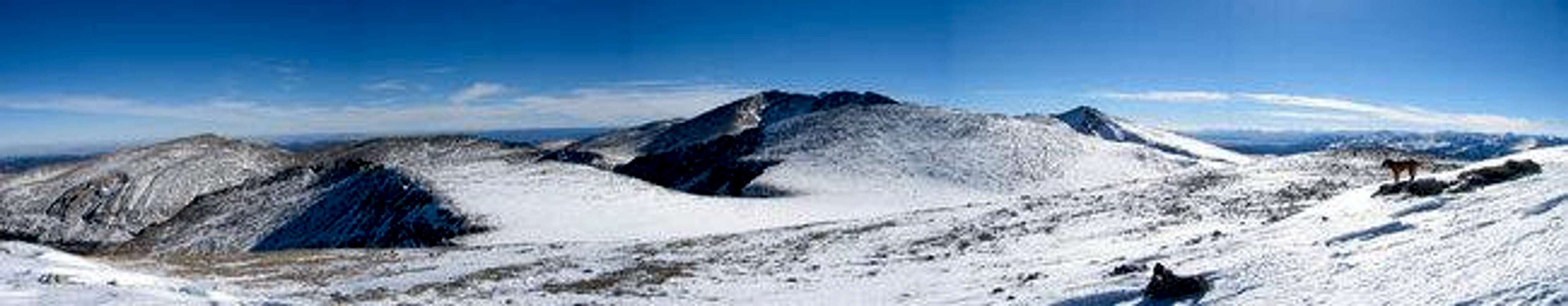
The Mount Evans Massif from Gray Wolf Mountain's summit. Rogers Peak, Mount Warren, Mount Evans, Mount Spalding, and Mount Bierdstadt are lined up from left to right.
The Mount Evans Wilderness is the closest wilderness to Colorado’s capitol city, Denver. It guards the glaciated highlands of the Mount Evans Batholith. It protects a 74,401 acre preserve that abounds in alpine flora and fauna. Although only 32 miles from the golden domed Capitol Building it is a world away. Mount Evans and its satellite summits form the spectacular mountain backdrop that is visible to millions along the Front Range. When approaching Colorado’s Rockies from the east, Mount Evans, along with Pikes Peak and Longs Peak, are the first high summits to loom over the horizon.
Designated wilderness in 1980 the Mount Evans Wilderness is remarkable in both how it is uniquely accessible, and yet even more uniquely, hides some very remote and lonely places. The Wilderness is penetrated by the 15 mile long Mount Evans Highway which climbs from the high Denver Mountain Park of Echo Lake. This roadway, built in 1927, is the highest paved roadway in North America. It is a windy two lane affair that offers a very intimate look at a diverse alpine ecology. Mount Evan's even had a restaruant near the top called the Summit House, until it burned down in 1979. Yet away from the roads lie 67 miles of trails crisscrossing glaciated valleys, lovely lake graced cirques, and alpine highlands. This diverse trail system offers a far more privileged wilderness experience.
The Mount Evans wilderness contains two fourteeners, the namesake Mount Evans, and the adjacent Mount Bierstadt. These two high summits see the vast majority of all visitors to the wilderness. Yet the wilderness contains 17 other named summits. These are: Rosedale Peak, Royal Mountain, Bandit Peak, Rosalie Peak, Tahana Mountain, Mount Logan, Spearhead Mountain, Arrowhead Mountain, Kataka Mountain, Geneva Mountain, Epaulet Mountain, Mount Spalding, Gray Wolf Mountain, Mount Warren, Rogers Peak, Goliath Peak, and Sugarloaf Peak. These summits offer many potential destinations.
- Mount Evans Geology: The Mount Evans region is dominated by the massive Mount Evans Batholith (A batholith is an igneous mass that has a determinate surface area exceeding 62 square miles, increases in mass in a downward trend, and has no determinate downward floor. It is essentially a mass of rock that extends up from the depths of the earth's crust). The Mount Evans Batholith represents a 1.44 billion year old magmatic intrusion into the surrounding 1.7 billion year old Precambrian Basement Rock. It occupies an immense area and consists of a distinctive coarse grained pink granite. The rolling tundra of the high summits is graced with many weathered boulders of this photogenic rock. This ancient granite lied buried and hidden until subsequent erosion stripped off the layers of sedimentation that had been deposited over the passing ages. The Laramide Uplift began the process of exposing the batholith. This rock was finaly exposed, carved, and sculpted by glaciers during the most recent glacial episodes in Colorado, occurring in two bursts 160 to 10 thousand years ago. The erosive power of glaciers left the previously rounded highlands riven with cirques, draped with morraines eroded off of them, and glacial lakes extending like strands of pearls along the valley floors (hence the name paternoster in reference to the resemblence to prayer beads). The effects of this past glaciation are readily apparent on visits today.
For more information on the geology of the Mount Evans area please see Jeremy McCreary's wonderfully informative website.
For more information on the Mount Evans Wilderness please see Mount Evans.com
Gray Wolf Mountain Overview
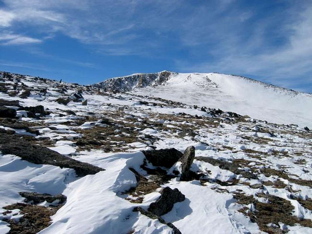
Gray Wolf Mountain is a high thirteener in northern end of the Mount Evans Wilderness. Gray Wolf Mountain is connected to the more popular Mount Spalding by a high and gentle expanse of rolling tundra. In spite of this demure southern appearance Gray Wolf has been deeply gauged by glaciation and the cliffs rising above the Chicago Lakes and Hells Hole are quite spectacular. The Hells Hole escarpment in particular is rugged and handsome. In spite of these cliffs many routes exist that skirt them.
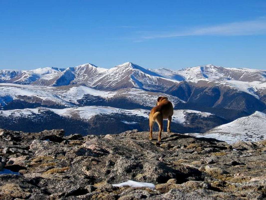
Gray Wolf Mountain is, if not a well known mountain, an often seen mountain. It is visible from Denver as a summit just poking over the shoulder of Rogers Peak. From the Chicago Lakes Overlook near Summit Lake it stands out as a rugged summit across the drainage. Gray Wolf Mountain has a spur that sticks off to the east that greatly adds to the impression of roughness from the summit lake vantage. This spur would also likely be worth visiting as its terminus would be a perch high above the Chicago Lakes.
The summit views of Gray Wolf are worth tasting. This is a unique vantage on the Mount Evans Massif and the northern Front Range. From its top you can spy both the skyscrapers of Denver and the huge intermountain basin of South Park. I was lucky to be able to linger here for over an hour in early November soaking in the beauty.
For a historical look at Gray Wolf mountain please see this 1915 photograph from the Chicago Lakes Overlook. Here is a well known view of Summit Lake and Gray Wolf Mountain taken by Louise Charles McClure in 1926. The famous William Henry Jackson apparently climbed at least partway up Gray Wolf Mountain to shoot this 1890 photo of Mount Evans and lower Chicago Lake
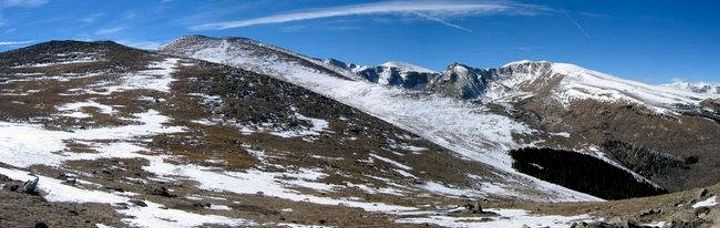
Rogers Peak, Mount Spalding, and Gray Wolf Mountain above the lower Chicago Lakes drainage. This view is from near the Mount Evans Highway as it climbs above timberline.
Approaches
There are three potential ways to access Gray Wolf Mountain.
- The most popular and common route. Drive to Guenella Pass 12 miles south of Georgetown. This is a scenic byway and it is well signed. The trailhead gives access to the willow ridden western route on Gray Wolf.
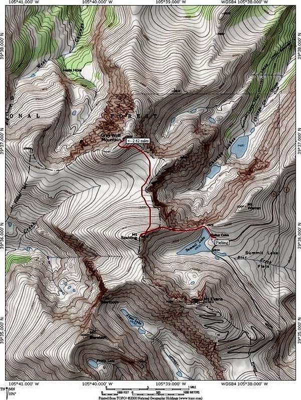
- The easy Mount Spalding Traverse is acessed by the Summit Lake Trailhead. To get to summit Lake take Highway 103 from either the central exit in Idaho Springs or the Squaw Pass Road turnoff of the Evergreen Parkway near Bergen Park. All acesses are well marked with signs pointing to Mount Evans. 18 miles from bergen park or 15 miles from Idaho Springs Echo Lake is reached. From the east side of Echo Lake continue up the seasonal toll road. This road is only open from June till September and costs $15 to use.
Follow the Mount Evans Highway 10 miles to Summit Lake.
- The route prefered by the author is the Chicago Lakes Route which starts at Echo Lake. Turn on Highway 103 from either the central exit in Idaho Springs or the Squaw Pass Road turnoff of the Evergreen Parkway near Bergen Park. All acesses are well marked with signs pointing to Mount Evans. 18 miles from bergen park or 15 miles from Idaho Springs Echo Lake is reached. The trailhead is at the west side of the lake.
Routes on Gray Wolf Mountain
There are three approaches to Gray Wolf Mountain: Chicago Creek, Guenella Pass, and Summit Lake. See above approaches for directions.
- Guenella Pass Route. I will describe this briefly as I have not attempted it. I have however viewed the route from many angles and decided I didn't want anything to do with it. It is however the most expeditious route up Gray Wolf. The reason for my distaste is the Guenella Pass willows.
From the Guenella Pass parking lot follow the Mount Bierstadt trail to the first lake. From here you just need to navigate through the willows trending north east. Along the way you will cross a dimunative willow chocked drainage whose source is the headwall that makes up the Sawtooth Ridge. Once past the willows the southern slopes of the west ridge of Gray Wolf should prove easy. It all depends on how you feel about chest high willows.
- Mount Spalding Traverse: 5.25 miles roundtrip, 1,500 feet elevation gain (on two mountains), Class 2.
Begin at the Summit Lake parking area. Go north along the eastern side of the lake to the Chicago Lakes Overlook. From here go up the fun scampering terrain of Mount Spalding's east ridge. From Mount Spaldings summit Gray Wolf Mountain rises above high tundra just to the north. This is gentle terrain and may be strolled across. One caveat though, from the summit of Gray Wolf Mountain all escapes off the highlands lead into drainages that are a good walk from the Summit Lake Trailhead. Thus if you need to abandon the high ridge for the Chicago Lakes drainage to escape a storm you will have a much longer day.
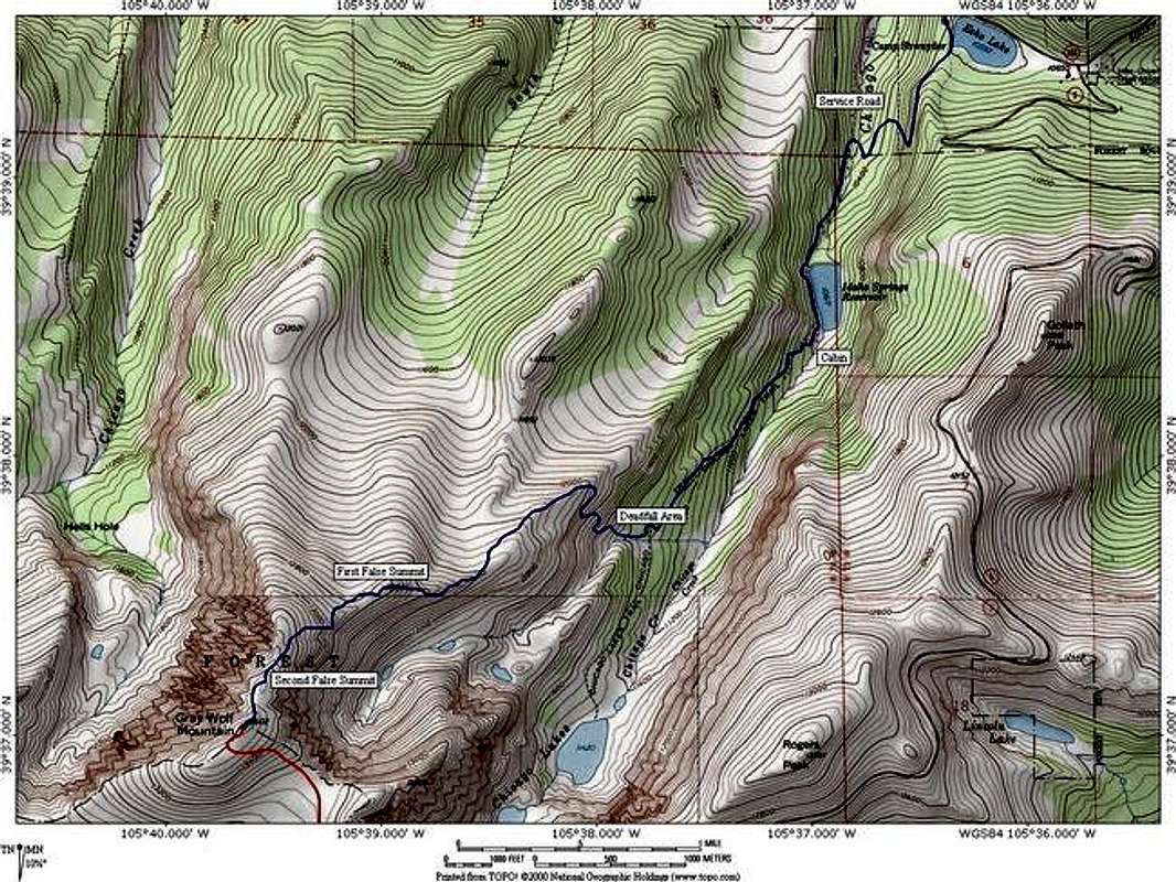
- Chicago Creek Route (ascent via north-east ridge): 11.2 miles, 3,000 feet elevation gain, class 2.
Begin at Echo Lake. Follow the trail around the western side of the lake with the signed junction with the Chicago Lakes Trail. Continue straight at the junction and continue along a slope above the Chicago Creek Drainage. The trail quickly switch-backs down to Chicago Creek. After crossing the creek continue south-west on a service road. A reservior that provides water to Idaho Springs is passed on the left. After passing a cabin the road disappears leving an excellent trail that finaly enters the wilderness. This portion of the trail meanders into the upper reaches of the Chicago Lakes Basin terminating near the second lake. The route however leaves the trail after passing into an area of downfallen trees. The route requires gaining the ridge visible to your left. The easist way to get up it is to continue along on the trail until you near the point it is closest to the ridge and a creek that runs in from the west. This way you buy pass boulder hopping amidst downfallen trees. Cross the creek heading north then find your way up the steep slope. Above is timberline and the wide open tundra of Gray Wolf Mountains north-east ridge. The summit is visable from low on the ridge. Continue up this long long ridge enjoying two false summits. In winter the ascent up the first false summit seemed to host an area of acumulation above a steep slope that should probably be avoided in dangerous snow conditions. There likely would be an alternate route just to the north that would bypass this one suspect slope. By and large the ridge is expansive and gentle. Continue along the obvious route. After the second false summit the true summit is seen as a rounded mound a little to the south west. From the top the view is expansive.
Red Tape
This mountain is in the Mount Evans Wilderness. Wilderness regulations aply. The Mount Evans Highway is a fee area. For more information please contact:
Clear Creek Ranger District
101 Chicago Creek, Box 3307
Idaho Springs, CO 80452
303-567-2901
Mountain Conditions

External Links