
-
 26050 Hits
-
 89.01% Score
-
 28 Votes
|
|
Mountain/Rock |
|---|---|
|
|
48.93470°N / 121.789°W |
|
|
5712 ft / 1741 m |
|
|
Overview

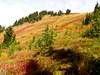
While the summit is little more than a bump on an east-west ridge, this delightful little peak has some incredibly impressive North Cascades payoff views and neat little features itself. First, there are three trails to achieve the summit, each with its own merits and advantages. The easiest goes just over 3 miles with 1600 feet of gain but travels through forests with lakes and colorful meadows. You'll pass Damfino Lakes in under a mile. These were named when a ranger who was asked the name of the lakes replied "Damn if I know." At about 2.5 miles you will travel through beautiful meadows under the summit. Another goes directly up from Highway 542 for 4-5 miles with 3800 feet of gain. This trail faces south and melts out in May or June making for a good early season workout. The longest trail goes up through Welcome Pass and then is a view-filled ridgewalk. This last one is 7.5 miles to the summit with 4400 feet of gain from all the ups and downs.
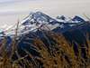
Regardless which trail you may chose, the views are amazing. First of all, there is nothing higher between Excelsior Peak and Mt. Baker which is only 11 miles south. The views of the north side of Baker alone make this a worthwhile trip, plus, they come right at the end as you reach the summit so the payoff is huge. Aside from that, Shuksan is only a half turn to the left. To the north are the Border Peaks and other icy glaciated mountains far into Canada. On clear days, you can see the Olympics to the southwest as well. Meadows also are all around you on the summit.
This is a pretty popular hike as the Excelsior Ridge is close to a main road so accessibility is easy. Expect some people on the trail but not as many as you would think. This is still pretty far north and on a dead-end highway. You may run into some horses and riders near the summit. There is a great flat camping spot just a couple hundred feet below the summit but remember, this is grizzly country so be prepared and hang your food if you are staying here.
Excelsior Peak lies within the Mount Baker-Snoqualmie National Forest and you will need a pass to park and hike (see below for details). The summit was the site of a lookout from about 1035 until 1969 although little remains of it now. What does remain are incredible views in one of the best areas in the Pacific Northwest.
 |  |  |  |  |
Getting There
From Seattle, take I-5 north to Highway 542. Take Highway 542 east through Glacier, WA. If you are looking to do the easy route, go a little less than 2 miles east of Glacier, and turn left on Road 31, Canyon Creek Road. It is just after the Douglas Fir Campground. Take Road 31 for about 14 and 1/2 miles to a parking lot in a clearcut.The south-facing route that goes up from Highway 542 starts about 8 miles east of Glacier at a small parking area with a trail sign across the road that reads Trail No. 670.
To get to the longer ridgehike, take Highway 542 11.5 miles past Glacier to Service Road 3060 on the left somewhere between mileposts 45 and 46. Go left up this road to the end. Take the trail up 2.5 miles to Welcome Pass and go left on Trail 630. 5 miles of ridgewalking gets you to the summit.
Red Tape
Northwest Forest Pass required to park.When To Climb
Mid-July through September. The easy trailhead is at 4277 feet so snow will linger here late. You can probably access the south route from Highway 542 in May though.Camping
Near Canyon Creek Road #31 is Douglas Fir Campground. Nice sites and clean restrooms.Just past the Service Road for the ridge trail is also Silver Fir Campground
There are spots to camp around Damfino Lakes although the area is full of blueberries and I would avoid it when they are fresh and ripe as there would surely be bears in the area. As stated above, there is a nice spot just below the summit in the meadow to camp and the summit itself would make a nice campsite.
Mountain Conditions
Glacier Public Service Center(360) 599-2714
Mt. Baker Ranger District
Weather for Glacier, WA
The Summit View

Cascade Scrambler - Sep 1, 2012 11:51 pm - Hasn't voted
Canyon Creek Road closedCanyon Creek Road is closed, apparently permanently, at milepost 0.0.
Brian Jenkins - Sep 2, 2012 2:33 am - Hasn't voted
Re: Canyon Creek Road closedWell that stinks. Thanks for the info. Hope you didn't have to find out the hard way on that. Brian
Cascade Scrambler - Nov 9, 2012 11:55 pm - Hasn't voted
Re: Canyon Creek Road closedNah, I picked a couple different mountains for that day, and Excelsior was my first choice. Upon finding out the road was barricaded with large boulders and barricades, I moved on to #2 on my list. No worries though. Here's what it looked like as of September 2012: http://images.summitpost.org/original/824647.JPG
Brian Jenkins - Nov 12, 2012 9:29 pm - Hasn't voted
Re: Canyon Creek Road closedYep, that looks pretty permanent.
EastKing - Jun 18, 2015 10:22 am - Hasn't voted
Canyon Creek Road now openAs of 2015 the road is now open and the Damfino Lakes Trailhead has been renovated. The road is rough but it is open.