

-
 68076 Hits
-
 89.85% Score
-
 32 Votes
|
|
Area/Range |
|---|---|
|
|
48.70626°N / 121.11431°W |
|
|
Hiking, Mountaineering, Trad Climbing, Ice Climbing, Mixed, Scrambling, Skiing |
|
|
Spring, Summer, Fall, Winter |
|
|
10781 ft / 3286 m |
|
|
Overview
Please don't down rate this page, it is under construction. I do want to make this page as good as possible!
(Currently Working on the Access Part)
"I have roamed many foreign parts my boys, and many lands have seen. But Columbia is my idol yet, of all the lands she is queen."
-Parson Smith, June 8th, 1886
When trapper Allen (Parson) Smith carved those words into a tree 12 feet this side of the Canadian Border, he was one of the many who traveled great lengths to reap the rewards of the legendary North Cascades. The rewards of those days were pelts, furs, gold, copper, and many other minerals.
Nowadays however, people come here for different reasons. To climb towering volcanos draped with glaciers, to lead trad routes up granite spires, to hike high passes and lucious meadows, or to backpack long and far, deep into the heart of a wilderness that has never known the plunder of man.
And wild it is. It took over 100 years of expeditions before a trans-Cascade route was discovered. Alexander Ross was one of the more famous explorers. In the early 1800s he set out on his first quest to find said route. He traveled from the Methow, along the Sawtooth Crest, before heading over Twisp Pass, down Bridge Creek and the Stehekin river, and over Cascade Pass to the Skagit.
Ultimately, now the only way you can drive across the range is via the North Cascades Highway. It follows the Methow drainage up over the Crest at Rainy Pass, and finally down Granite Creek to the Skagit. This isn't your standard road, however, sometimes it doesn't open as late as June, and closes each October. In April 2011, there was a whopping 70 feet of snow at Washington Pass, one of the passes on the highway. That's at 5000 feet. Now can you imagine what it's like in the high country?
Where to Draw the Boundaries?
From the North to the South the Fraser River (Canada BC) represents the Northern section, while Highway 2 is considered by many the Southern Border. It is debatable to say that I-90 is more along the lines of the Geographical Divider but for the sake of what is commonly known as the North Cascades by most alpinist this page will consider the Southern border Highway 2.
For the boundaries from West to East the foot hills East of the Puget Sound make up the North Cascades West border. The Columbia and the Similkameen River are considered to be the East border of the North Cascades.
Access into the North Cascades
Also this section in under construction!
There are many access points to get into the North Cascades, but there are 4 major access highways to get into. For the sake of simplicity I'll start from North to South.
Access to the Canadian North Cascades: From East to West Highway 3 drives along the Northern most boundary of the North Cascades.
Mount Baker Highway: Highway 542 comes from the West to the East
Directions to the North Cascades National Park: Drive East on Highway 20...
History/Background Information
The first known people to live in the region of the North Cascades were the Skagit, Sauk-Suiattle, and the Nooksack native American tribes who were on the Western part of the North Cascades. On the Eastern side were the Okanagan people which to this day the major rivers and wilderness's are named after these tribes... (more history coming later)
Attempts to find a route across the range, suitable for trains and trade, started in the early 1800s, when miners first started to explore the area. Alexander Ross made one of the most notable early attempts. He and an Indian guide traveled from the Methow Valley west, traversing Sawtooth Ridge, before dropping over Twisp Pass and through the Stehekin drainage to Cascade Pass. On the west side of the pass Ross encountered a "west flowing stream [Cascade River], and knew [he] had reached the Skagit".
But trouble was far from over. That night a horrible storm hit, causing trees to crash all around them. Ross later described it as a "hurricane". His Indian guide saw this as a message from the gods that they had "tresspassed on the sahale [high country]", which was the home of the gods and a place man must never go. The Indian abandoned Ross, who later found his way back to the Okanogan, and told of his discovery of a pass and travels. MORE COMING SOON!
Later on it became a National Park on October 2, 1968 when Lyndon B. Johnson signed the North Cascades Act. In 1988 Congress designated approximately 93 percent of the three areas as the Stephen Mather Wilderness to provide additional legislated protection although rarely is it called that.
North Cascades National Park
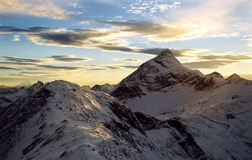
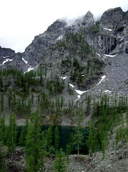
The North Cascades National Park is considered by many to be the heart of the North Cascades, home to some of the greatest views in Washington State. It contains 685,000 acres of Glaciated Mountains, Rivers ,and lakes. There used to be 750 documented glacier in the 1950's. In 2005-2006 there are 650 Glaciers that are left, nearly 70 of these are gone. Nevertheless, there are more glaciers here than anywhere else in the lower 48.
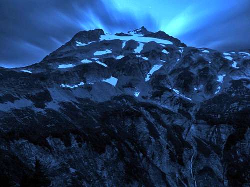
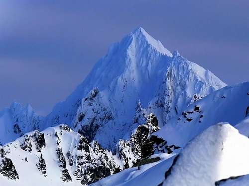 Eldorado Peak in Winter
Cascade Valley

The Cascade Valley ends at the city of Marblemount which is on the west side of the valley. Cascade Valley marks the Southern border of the North Cascades National Park (not the North Cascades itself). One could describe the Cascade Valley being split up into 3 sections, the North, Middle, and South Cascade River which divides the land. The Middle and Southern valley forks are in the Glacier Peak Wilderness. This is among a great set of Cascade Peaks, which is why it is my favorite valley. It is most commonly entered through the West side from Marablemount, which a road goes through most of the Cascade Valley, but not through the middle and South Fork. It can some times be closed through out the winter months, and Early spring, and depending on the snow pack or if there was a wash out, it can even be closed 3 miles from the trailhead the enture year, but is often opened by August through October, and some times open June and July.
North Fork: The North Fork is the most commonly the most populated in summer, due to Cascade Pass, which is a great day hike and is only 3.9 miles to get to. And of coarse for those who want more, theres Sahale Arm and Sahale Mountain. Also theres Bosten Basin and Hidden Lake Peaks which are also Classic North Cascade hikes, and for those who are more into climbing, there's Eldorado Peak, Bosten Peak, Mount Torrment, and Forbidden Peak.
Middle Fork: The middle Fork of the Cascade Valley is said to have an old trail that goes through part of it, which goes to Mount Formidible. This Mountain can also be accessed through the Ptarmigan Traverese, which is a multi day back pack trip through non trail terrain which requires knowledge in Glacier travel.
South Fork: The South Fork which I believe theres no trail, and is a long trek, goes to South Cascade Lake, which near it is South Cascade Glacier, which is unfortunately melting away due to Global Warming. Also Dome Peak is a part of this section of the Valley.
This section is also under construction...
The Canadian Cascades
Coming Soon...
 Looking South Towards Mount Baker from Canada
The Mount Baker Area
Coming in from the Seattle Area:
Get off at exit 230 and take a right onto highway 20. Very soon at a light the road takes a left at a light which you turn onto S.Burlington Blvd and then a right onto Avon Ave. Technically it is still considered part of the highway but with sub names which in my opinion makes it slightly confusing if I didn't already know the way. In 5.8 miles take a left onto highway 9 (North). After 22 miles you end up in the city of Deming, take a right onto highway 542. From here the road goes all the way to the Mount Baker Ski Resort, but before the ski area there are plenty of options to choose from! I'll list a few good examples on the way, Mount Baker (directions)
Coming from North of Bellingham (Lynden, Abbotsford, and Vancouver):
From Lynden: Head east on 546 which then turns into highway 9. Then as you head north you take a right (East) onto Highway 547 (W Front Street) which goes all the way to Kendall, go straight which goes onto 542 (East Again) which will take you to the Mount Baker Ski Resort.
From Vancouver: Head south to Bellingham until you see 542 which from here you go East on it until you get to the Mount Baker Ski Resort.
 Mount Larrabee during Winter |
 Lenticular Forming on Shuksan's Summit |
 Mount Sefrit |
The Pasayten
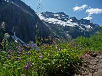
Much of the beauty of the North Cascades is raw: you look at it, your jaw drops, you move on. But then there's that special kind of beauty, where at first you may not see it, or think that the effort:reward ratio is a little skewed, but then you think about it. You notice the solitude. You realize that here is one of the few areas in the state that have grizzly bears and moose. You see mining relics and old, tilting cabins, footprints of an age where everywhere was this wild. This remote. This untouched. And that's the Pasayten.
Compared to the shaggy, craggy, glacier-dollaped Alps of most of the range, the Pasayten seems like easy terrain. But long approaches, unmaintained trails, and heavy blowdown solves that problem for 'ya.
I (Tangeman) personally have only been in the Pasayten three or four times. But it gets to you. You get addicted to it's wildness and solitude. And realize it's what mountain areas should be like.
 It's wild country...
Pasayten Peaks are often reffered to as "High Rollers" because they're high and gentle. But don't let it fool you, there is ruggedness...

Red Tape
Outside of the North Cascades National Park there are no overnight permit regulations, although many of the trailheads require a northwest forest pass. In the North Cascades National Park a Back country Permit is required for overnight camping.
Camping

Camping Near South Twin
For now here is the big list!
https://www.nps.gov/noca/planyourvisit/backcountry-camps.htm
Weather and Conditions of the North Cascades

Storm Clouds Heading In

Lenticular Cloud over Shuksan
Weather: Keep in mind that weather for the North Cascades is hard to predict at times. Just the other day I was on a climb which they predicted decent weather which a storm came in with heavy rain. So always be prepared for storms in the high lands of the North Cascades. And always keep an eye on the horizon.
Weather for cities in the Canadian Cascades:
Road Conditions:
https://www.nps.gov/noca/planyourvisit/road-conditions.htm
Avalanche Forecast:
Western North Cascades Avalanche Forecast from Nwc
Eastern North Cascades Avalanche Forecast from Nwac
Steven's Pass Area forecast from Nwac
External Links
Coming Soon...
What's in a name?
Under Construction! Chill, people...
Here's a section devoted to explaing some of the name origins of features in this range.
North Cascades:'Cascades' simply comes from the numerous streams, creeks, rivers, and waterfalls born by heavy snowfall and rain. It's just the northern part of the range.
Mount Baker:named by George Vancouver in the 1700s after Captain Joseph Baker. The Indians called it Koma Kulshan.
Silver Star Mtn: This awesome peak near Mazama is so named because of a star that can supposedly be seen on the west face. Whether it was a snow design or rock formation, I don't know, I've never been able to make it out, but someone must've.
Pasayten: Some say it's an Indian word meaning "water from gentle mountains", which would be fitting. Others say it's from the French, (many French trappers trapped in the area) they say it's derived from "Pays du Saten" which translates to "Land of Satan". This would go along with some Pasayten area names like Devils Dome, Hell Basin, Devils Pass, Devils Peak, and others.
Three Fools Area: In the 1800s, a group of three miners were prospecting in the Ruby Creek area, when rumor told them there were greater gold fields to the North. The fell for this scheme, and made it as far as the NW Pasayten. Their fate is told in such names as Three Fools Creek, Freezeout Pass, Blizzard Peak, and Nightmare Camp.
Glacier Peak: It shouldn't be a mystery to how this mountain got it's name. It's original name, however, was a Sauk-Suiattle name "DaKobed", which means "Great Parent". This name was preserved in the Dakobed Range southeast of the mountain. Others may know Glacier Peak as YES! Peak.
Napeequa River: The name of this tributary of the White River literally translates to "White River" in a Wenatchi dialect. The Indians did not give it this name, however, water milky with glacial silt was too common to be a name-giving characteristic.
Mount Spickard: This mountains original name was 'Mount Mox', but that was changed after Warren Spickard died on nearby Mox Peak.
Gardner Massif: Gardner and North Gardner were named by Winthrop founder Guy Waring after Isabella Gardner, a Boston woman. That is the same person that nearby Isabella Ridge is named after.
 Copper Glance Lake, below Sherman Pk, the highpoint of Isabella Ridge.
Mount Lago: This high Pasayten Peak was named after explorer and early first ascentionist Lage Wernstedt.
Guidebooks, etc.
Here is a list of recommend on guidebooks for the range, and just informational and interesting reads.
Guidebooks:
Cascade Alpine Guide, vol. 2 and 3 by Fred Beckey. A classic.
Hiking from here to WOW: North Cascades by Kathy and Craig Copeland. One of the better hiking guides out there.
Selected Climbs in the Cascades, vol 1 and 2 by Jeff Smoot. Another classic.
Just..books.
The Smiling Country by Sally Portman. Tells the history of the Methow Valley. Very interesting.
more later...
Wildlife and Flowers
 Deer near Mount Logan Deer near Mount Logan |
 Mountain Snake Mountain Snake |
 Goat on Sahale Goat on Sahale |
 Tiger Lillie Tiger Lillie |
 Marsh Marigold Marsh Marigold |
 Flowers with Mount Sefrit Flowers with Mount Sefrit |
Sunsets and Sunrises
 Sunrise on White Horse Sunrise on White Horse |
 Sunset on Mount Baker Sunset on Mount Baker |
 Alpenglow on White Chuck Alpenglow on White Chuck |
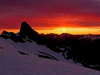 Sunrise on Jack Mountain Sunrise on Jack Mountain |
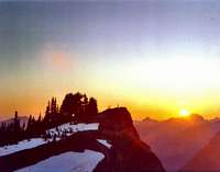 Sun Setting on Mount Dickerman Sun Setting on Mount Dickerman |
 Buckner Mountain Buckner Mountain |
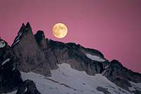 Gunsight with the Moon Gunsight with the Moon |
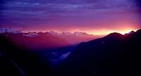 Ptarmigan Traverse Sunset Ptarmigan Traverse Sunset |
 West McMillan Spire West McMillan Spire |
Fall Colors
 Granite Mountain Granite Mountain |
 Snowy Lake Snowy Lake |
 The Pickets during Fall The Pickets during Fall |
 Mount Pugh Mount Pugh |
 Red Colors on Sahale Red Colors on Sahale |
 Golden Light on Hinkhouse Golden Light on Hinkhouse |
Evening and Morning
 Evening on Big Four
 Three Fingers Mountain
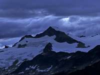 Eldorado Peak
 Sahale during Evening
Eric Sandbo - Nov 11, 2011 7:08 pm - Hasn't voted
The CascadesThe Cascade Range wasn't named after all the waterfalls that decorate it, though it seems to make perfect sense. Pioneers on the Oregon Trail finished their journey by rafting down the Columbia, except if they went over the falls at the Dalles, they risked their lives. Those falls are drowned under the reservoir behind the Dalles Dam now, but the entire mountain range is named after them. To people desperate to reach Oregon City before winter slammed into them, the mountains would have been easily bypassed on the river -- except for those Cascades.