
-
 17460 Hits
-
 82.48% Score
-
 15 Votes
|
|
Mountain/Rock |
|---|---|
|
|
37.29992°N / 113.09329°W |
|
|
Scrambling |
|
|
6430 ft / 1960 m |
|
|
Overview


Because of a seeming similarity in appearance to the dome of the Mormon Tabernacle in Salt Lake City, early Mormon ranchers dubbed this small but fun and aesthetic peak such. It is literally right next to the road (with a short but miserable approach due to brush) and can be climbed in less than two hours round-trip (3-4 hours is more likely for most parties, though), but this peak is the epitome of one that packs a lot of bang for the buck. Once the approach is over, the route is highly enjoyable, and summit views are jaw-dropping.
This peak has no route easier than Class 5 on it, with the easiest going at about 5.2, though the exact variation I took had me in one spot that felt more like 5.4. Pitches can be rappelled but don't offer too much in the way of opportunities for placing protection, so leave the nuts and cams and such at home, bring rope and slings for rappels if desired, and be ready for a few pitches of Class 5 scrambling, some of it highly exposed.
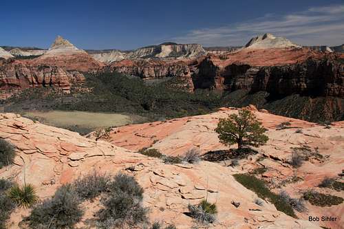
It's worth the scare, though. The views from up top extend west to the Pine Valley Mountains and east to the peaks that comprise the west rim of Zion Canyon, but the money shot is that between the summit and Zion Canyon's west rim. This is Kolob Terrace country, remote and scenic, and you get a killer view of two of Zion's most iconic peaks, North Guardian Angel and South Guardian Angel, the latter of which is also reputed to be one of the most challenging and least climbed of the major nontechnical peaks of the Southwest (challenging mainly because of the route-finding and climbing challenges along the approach).
In short, this little peak kicks some serious ass.
Getting There
From Virgin, turn north onto Kolob Terrace Road. This road, even though it passes through Zion National Park, is not signed for the park, but it is signed for Kolob Reservoir. Drive 9.5-10.5 miles on this paved road and use one of the small pullouts to park. Park as close to the northwest ridge of Tabernacle Dome as you can.
Route
From the road, it is a short but unpleasant hike and bushwhack to the base of the peak. Drop into a wash, climb out, drop into another wash, climb out again, and then drop into a third wash adjacent to the base of the peak. Use game trails wherever you find them. Expect to bleed if you do not have long sleeves and pants on.
There is a much easier approach possible from a dirt road shortly up the road, but this would mean crossing private property. I have no idea how friendly the landowners are and certainly do not advocate trespassing.
Update: I have been told that the landowner sold the property to the park and that trespassing no longer is a concern.
You will find that a number of chutes/gullies head up to the lower portion of the northwest ridge; your goal is to find the one that works the best. I'd provide a photo with a route line, but I'm not so sure that the way I planned from the road was the way I actually went up. Instead, use these comments and the photos below: find a somewhat brushy gully that in 2012 had a large dead tree fallen in it near the top that made for useful handlines, traverse to your left a bit (includes an exposed section), and climb a clean chute that resembles a slot or a dryfall. If you use those lines, the climbing stays at about 5.2; a different chute I used on the ascent was more like 5.4.
 |  |  |
Above the chutes, work your way left and gradually up and to the right of some prominent hoodoos until you reach the base of the northwest ridge proper. Now head up. The ridge climbs about 250' to the summit from here. At first, you're on pretty easy Class 3/4 slabs. Around the middle, though, the ridge steepens and the holds become a bit more elusive; the going is now Class 4/5 and exposed to the point that a slip would probably prove fatal, and two trees with slings around them attest to the fact that some choose to rappel this section on the descent.
 Hoodoos... Hoodoos... |  |
 The ridge... The ridge... |  |
Above this steeper section, the grade abates and becomes Class 2/3 the rest of the way. The highpoint is one of a few small outcrops, and the summit area itself is a big slickrock bowl with expansive views. At the highpoint in 2012, there was a cairn but no register.
Summit view of the Guardian Angels
Camping
The closest campground is several miles north at Lava Point; it is small and only open late spring through early fall, so not worth planning on. You can't set up a tent roadside or at trailheads within the park out here, but if you sleep in the car, chances that a ranger will mess with you are close to nil, especially if you're smart enough not to catch your forty winks at the Left Fork (Subway) trailhead. Kolob Terrace Road cuts through parkland, private land, and BLM land; dispersed camping is okay on BLM land. Just make sure you know whose land you're on.Red Tape
No fees. The major concern out here is to be careful about trespassing. Update: an SP member has informed me that the landowner adjacent to the peak sold the property to the park and that there no longer are any trespassing issues.One thing worth mentioning since this is a Class 5 peak: establishing new bolts is prohibited. If you think you need to install bolts to climb this peak, please stay home and wait for the movie.
ratagonia - Apr 21, 2015 9:44 pm - Hasn't voted
Tab Dome AccessThe private landowner sold to the Park. No trespassing issues now.
Bob Sihler - Apr 22, 2015 9:22 am - Hasn't voted
Re: Tab Dome AccessThat's great to know. I will add it to the main page. Thanks!