
-
 26347 Hits
-
 86.29% Score
-
 22 Votes
|
|
Mountain/Rock |
|---|---|
|
|
37.18469°N / 112.97871°W |
|
|
Hiking, Trad Climbing, Sport Climbing, Aid Climbing, Big Wall, Scrambling, Canyoneering |
|
|
Spring, Summer, Fall, Winter |
|
|
6555 ft / 1998 m |
|
|
Overview
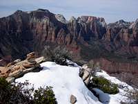
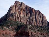
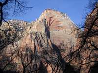
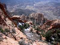
The Watchman is one of Zion National Parks most recognized feature. It sits prominently above the South Entrance Park Headquarters, the Watchman Campground and the town of Springdale, Utah. As part of a jagged ridge line that runs on the East side of the Zion Valley, it guards the southern portion of this ridge. The most famous and recognizable shot of this giant rock buttress is usually taken from the north near the Watchman Campground.
Like many of the area's peaks, The Watchman contains several challenging free and aid climbs, along with one known scrambling route that requires careful route finding to avoid 5th class. The technical climbs generally start on the west to north rock walls, as viewed from the Springdale area. The non-technical scramble ascends a northern portion of Johnson Mountain before descending to the base of the west face of The Watchman- a portion of the mountain hidden from roads views. The true summit of the Watchman is several towers south of what appears to be the high point as viewed from the Zion Valley. Views from the summit are tremendous and all encompassing and include nearby Mt. Kinesava, Johnson Mountain, Bridge Mountain, The West Temple, Towers of the Virgin, and the East Temple, to name just a few. In fact, there are over 20 officially named peaks within 5 miles of The Watchman. This area is truly a climbers and hard scramblers paradise.
Routes
- The West Face Scramble Route- Class 3-4 with route-finding challenges. One wrong slot leads you into Class 5 territory. See Routes for more.
- S&M- 5.10+ IV, A0. 6 pitches of mostly free climbing (one small aid section) that ascends an off-width crack with finger tip moves. Starts on a tower just to the right of the highest point of the Watchman ridge as viewed from Springdale. Scramble up to the true summit and descend via the Scramble Route, or make 3 rappels from the notch. First ascent by the Austins, 1984.
- The Vigil- 5.11 IV 10 pitches. Highly recommended climb starts just to the left of S&M in a right facing dihedral that is 100 feet from a cleaner looking crack system near a white ramp. A large talus boulder lies next to (left of) the start of the route. The pitches go at 5.8, 5.7, 5.10, 5.9, 5.11 (or A2), 5.11, 5.10, 5.8, 5.11, then 3rd class. A large tree marks the top of the 4th pitch on Violation Ledge and is visible from the Springdale area. Continue 3rd-4th class to the true summit and use the scramble descent or take 4th-5th class on the northwest ridge, then rappel into the gulley.
Getting There
Weather, Seasons, Conditions
Many of the southern summits of Zion (like Kinesava) can be climbed virtually year round. Be aware that snowstorms can occur during the winter and snow will linger on the north sides. Strong late winter / early spring sun usually melts the west to south exposed sections.
Zion Valley Climate Data:| Jan | Feb | Mar | Apr | May | Jun | Jul | Aug | Sep | Oct | Nov | Dec | Annual | |
| Average Max. Temperature (F) | 51.8 | 56.8 | 64.0 | 72.8 | 83.0 | 93.8 | 99.6 | 97.0 | 90.1 | 78.0 | 62.7 | 53.1 | 75.2 |
| Average Min. Temperature (F) | 29.0 | 32.7 | 37.0 | 43.6 | 52.2 | 61.3 | 68.6 | 67.2 | 60.3 | 49.3 | 36.9 | 30.0 | 47.3 |
| Average Total Precipitation (in.) | 1.67 | 1.86 | 1.89 | 1.17 | 0.79 | 0.47 | 0.99 | 1.42 | 1.06 | 1.06 | 1.25 | 1.35 | 14.99 |
| Average Total SnowFall (in.) | 3.4 | 1.7 | 1.0 | 0.1 | 0.0 | 0.0 | 0.0 | 0.0 | 0.0 | 0.1 | 0.6 | 2.0 | 8.9 |
| Average Snow Depth (in.) | 0 | 0 | 0 | 0 | 0 | 0 | 0 | 0 | 0 | 0 | 0 | 0 | 0 |
For current weather conditions and forecast at Springdale, UT click here
General Zion Valley Overview Map
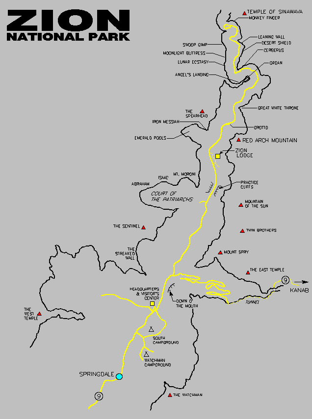
Most scrambles and approaches involve some level of bush-whacking in Manzanita, Sage, juniper, and many types of cactus. Expect many scratches and prickers on your trip.
DonnieB - Mar 30, 2006 7:30 pm - Hasn't voted
AdditionsAdditional Watchman Beta (Pic's, GPS tracks and Map)
SawtoothSean - Mar 31, 2006 2:53 am - Hasn't voted
Good StuffNice addition to the page- good to have the additional pics and map. The GPS waypoints would make it easy for those that don't want the route-finding hassles. Thanks.
wschueller - May 14, 2017 5:57 pm - Hasn't voted
Access deniedAccess update May 2017. The bridge over the Virgin River onto Canyon Springs Drive now has a posting "Private Property. No Trespassing". Even wading across the river during low water would still involve utilizing this private drive. Theoretically heading south from Watchman campground above the river bank might be feasible but this is steep, loose terrain.