
-
 4030 Hits
-
 80.49% Score
-
 12 Votes
|
|
Mountain/Rock |
|---|---|
|
|
47.48014°N / 11.34508°E |
|
|
Hiking, Mountaineering, Skiing |
|
|
Spring, Summer, Fall, Winter |
|
|
7247 ft / 2209 m |
|
|
Overview
 Reissende Lahnspitze and south slopes as seen from Soiernspitze
This summit has a strange denomination: Reißende Lahnspitze, Torrential Avalanche Peak. If you ever see an avalanche rushing down the south slopes of that mountain you will understand this name. Reißende Lahnspitze can be a nasty piece of work in winter and spring time. A ski tour to this summit needs good planning and knowledge of the avalanche situation.
Being the second highest peak of the Soiern subgroup of Karwendel mountains, Reißende Lahnspitze is a year round outing but rarely a single aim in this subgroup. Located between Feldernkopf to the west and the eponymous Soiernspitze to the east, Reißende Lahnspitze often is one of several summits during one of these nice traverses which are possible in the Soiern subgroup.
As written above, Reißende Lahnspitze is a ski tour for the more advanced ski mountaineer and in summer and autumn a long and strenuous hike which requires some short scrambling near the top as the marked trail traverses the summit some 80 m below the summit cross.
My preferred tour is the traverse of Feldernkopf, Reißende Lahnspitze and Soiernspitze, climbing up and descending down to one of the Mittenwald trailheads. This is a long one day outing which is especially in late autumn and even in December with little snow a great thing to do: no people around, many chamois, slightly annoyed by your presence, good views and, if you are lucky, a good summit nap in the still warm November / December sun.
Getting There
 Reissende Lahnspitze and Soiernspitze
Main trailheads for Reissende Lahnspitze are
You reach Krün and Mittenwald by car
If you go by train, the best trailhead is Mittenwald / Kasernen, about 0,5 hours away from Mittenwald railway station.
Main Routes Overview
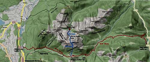 Routes of Soiern subgroup
There are many routes up to Reissende Lahnspitze, some of them can be combined to nice round trips.
from Mittenwald / Isarhorn or Mittenwald / Kasernen trailhead
- Route 1: trailheads – forest road – turn left on Lausberg trail – Lausberg – Signalkopf – Seinskopf – Feldernkopf (Ridge crest trail) – summit: an excellent traverse of several summits of the Soiern subgroup;
- Route 2: trailheads – forest road – Ochsenalm trail to Feldernkopf (Ridge crest trail) – summit (the upper part of the route is the same as route 1);
- Route 3: trailheads – forest road or Aschaualm and Jägersteig – Fereinalm – Hirzeneck (Hirzeneck trail) – Soiernspitze - summit;
 Traverse Feldernkopf - Reissende Lahnspitze Traverse Feldernkopf - Reissende Lahnspitze |  Summit view Summit view |  Summit as seen from near Schöttelkarspitze Summit as seen from near Schöttelkarspitze |
from Krün
- Trailhead – forest road to Fischbachalm – forest road or trail (Lakaiensteig) to Soiernhaus – Soiernsee – Soiernscharte (North cirque trail) – summit;
- or alternatively from Soiernhaus – Schöttelkarspitze – Feldernkopf (Ridge crest trail) – summit;
From Hinterriß
Trailhead – with MTB on forest road to Vordersbachau – Fermersbach valley and Fereinalm; ascent on Hirzeneck trail to Hirzeneck and Soiernspitze. From there descend and ascend again to the south ridge of Reissende Lahnspitze. Climb shortly up to the summit.
A rather long and lonely route (Fermersbach trail) starts near Oswald Hütte / road number L 282 to Hinterriß. Follow the forest road up to Paindl hunters cabin and the trail number 350 above Fermersbach valley to Hirzeneck. Turn right and ascent Soiernspitze on the Hirzeneck trail.From there descend and ascend again to the south ridge of Reissende Lahnspitze. Climb shortly up to the summit.
 Summit with Wetterstein range Summit with Wetterstein range |

Ski route
Normally you start from Mittenwald / Isarhorn trailhead. Use the forest road ascent to Fereinalm. At the meadow flat of Fereinalm choose on of the steep chutes through the dwarf pine zone and ascend then the steep south slope of Reissende Lahnspitze directly to the summit. Descend as ascended. Steep and dangerous (avalanches!) ski tour.
Signposts: The whole region has yellow signposts at trail junctions and trailheads to indicate directions. These signs show hiking hours and minutes to destinations, too, which sadly are often wrong (ways too long or too short). My advice: don´t take them into account!
Red Tape & Accommodation
The whole Soiern subgroup belongs to the nature protection area „Karwendel und Karwendelvorgebirge”, which covers nearly the whole German Karwendel area and is thus part of the huge Alpenpark Karwendel.The entrance is free.
Please respect the following rules in the Nature Protection Area:

 Reissende Lahnspitze
You find all kind of accommodation at
Mittenwald
Krün
Wallgau
Hinterriß
Mountain huts
Soiernhaus
Ferein Alm; also called Fereinsalm, Vereinalm or Vereinsalm; no overnight stay
Krinner-Kofler-Hütte, located near Fereinalm
Gear & Mountain Conditions
 Reissende Lahnspitze as seen from Wörner ascent
Reissende Lahnspitze is a year round summit.
All summer and autumn routes are hiking routes which are marked and signposted. Some of them are, however, strenuous and long, especially the full traverses.
In winter with little snow, Reissende Lahnspitze via south ascents and the ridge crest traverse may be open for a great winter hike.
Full hiking gear and enough to drink is needed for Reissende Lahnspitze.
Reissende Lahnspitze as a ski tour should be handled carefully. As the ski routes normally use the steep south slopes, avalanche conditions should be checked carefully. The denomination of the summit, Torrential Avalanche Peak, points out that there can be nasty avalanche incidents. No ski tour for beginners.
Check the Bavarian avalanche bulletin here.
Current Weather for Mittenwald:
Maps & Guide Books
 Reissende Lahnspitze (background with Soiernspitze)as seen from Mittenwalder Höhenweg
Maps
Topographische Karte, scale 1 : 50.000, Karwendelgebirge, Werdenfelser Land; Landesamt für Vermessung und Geoinformation Bayern
Alpenvereinskarte Bayerische Alpen, scale 1 : 25.000, map number BY 12, Karwendelgebirge Nord, Schafreiter; Deutscher Alpenverein, Landesamt für Vermessung und Geoinformation Bayern, 2010 (covers the easternmost parts of Soiersnspitze with Fermersbach trail and MTB route from Hinterriß)
Alpenvereinskarte Bayerische Alpen, scale 1 : 25.000, map number BY 10, Karwendelgebirge Nordwest; Deutscher Alpenverein, Landesamt für Vermessung und Geoinformation Bayern, 2010
Guide Book
Heinrich Klier, Fritz März, und Walter Klier: Alpenvereinsführer Karwendelgebirge alpin, Bergverlag Rother, 2005