
-
 8382 Hits
-
 84.82% Score
-
 19 Votes
|
|
Mountain/Rock |
|---|---|
|
|
46.48536°N / 12.08789°E |
|
|
Veneto |
|
|
Trad Climbing, Sport Climbing |
|
|
Spring, Summer, Fall |
|
|
7520 ft / 2292 m |
|
|
Overview
Geographical classification: Eastern Alps > Dolomites > Lastoni di Formin > Torrione Marcella
Torrione Marcella 2292 m
Torrione Marcella is a beautiful and well individualized tower typically dolomitic, emerging in the Northern sector of the very long West face of Lastoni di Formin, clearly visible from the road that in Pocol branches off from the Falzarego road in the direction of Passo Giau. Its narrow fine West wall facing the road features a high quality dolomia and it’s cut by two superb routes, running side by side and having two different characters, both deserving a visit in reason of the beauty of the rock and the interest of the climb.
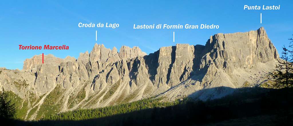
Torrione Marcella and Lastoni di Formin
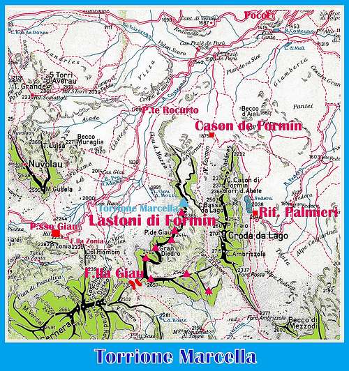
Getting There
The starting point to climb Torrione Marcella is located in a pull-out along the road running from Pocol to Passo Giau. This place can be reached from the town of Cortina d’Ampezzo m. 1230 (Belluno province), the main resort in this area, or from Passo Giau m. 2236, one of the highest pass in the Dolomites, offering a breathtaking view over the majority of the Eastern and Western Dolomites, located 16 km. to Cortina d’Ampezzo. This latter approach is shorter.
Road access to Passo Giau m. 2236
- From Belluno: follow the road SS 51 towards North reaching Longarone and Pieve di Cadore; from Pieve the SS51 turns to left, getting to San Vito di Cadore and Cortina d’Ampezzo. From Cortina take the road SS48 to Falzarego Pass and in Pocol turn to left (signpost Passo Giau), following the Road SP638 to Passo Giau (16 km. from Cortina).
- From Bolzano: take the Brennero Motorway towards North, exit Ponte Gardena and then follow the Val Gardena road to Selva di Val Gardena and Passo Gardena, reaching Corvara and La Villa. Turn to right towards Passo Falzarego, get the pass and here descent towards left along the road SS48 towards Cortina d’Ampezzo as far as Pocol. In Pocol turn to right and follow the road to Passo Giau (signpost).
- From Trento and Verona: take the Brennero Motorway towards North, exit Ora-Egna, then follow the road to Val di Fiemme and Val di Fassa, pass Cavalese and Predazzo; in Moena leave the main road and turn to right, following the Val di S. Pellegrino road to Falcade and Cencenighe Agordino. Here turn to left following the road to Alleghe, Caprile, Selva di Cadore, Passo Giau.
")
|

|
Walking access to Torrione Marcella West face
50 meters South to the signpost “Muraglia di Giau” – a huge stones-wall, which in the ancient times separated the Ampezzo pastures from the Cadore ones - leave the car in a pull-out on the left. A narrow trail crosses the meadows on the left of the road, then two streams. The path continues inside the wood, crossing some other streams and heading towards the visible tower. At the end of the wood, climb the last meadows and screes to the bottom of the wall (1 hour from the road).
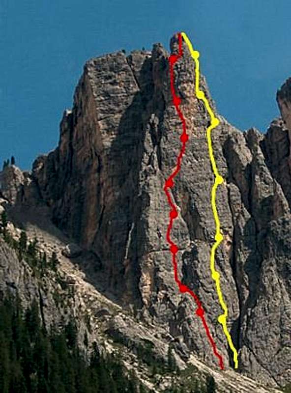
Routes overview: Nikibi and Paolo Amedeo report
Two selected climbs on Torrione Marcella W Face: a classic route (Paolo Amedeo) and a moderne one (Nikibi)
- Via Paolo Amedeo V+, 260 m. First ascent: Mario Dibona and Armando Nascè summer 2001
- Nikibi 6b, (6a, A0) 250 m.. First ascent: Mario Dibona – G. Alexander june 2002
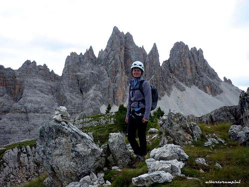
Croda da Lago seen from the summit |
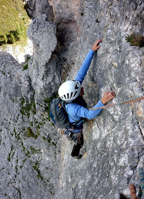
Nikibi beautiful slab |
- Via Paolo Amedeo A superb classic route on excellent "dolomia", requiring a bit of experience in placing running protections. The climbing style is mainly on cracks and dihedrals. The belays are equipped with bolts, while the pitches are equipped with pitons.
Starting point of the route: from the lowest point of the tower, skirt the rocks towards right getting to a corner.
L1 - Climb the corner to a little terrace on the right of a little tree IV+, 30 m.
L2 - Up on the right of the belay, then traverse right to a crack. Climb the crack to some steps. Belay. V+, then IV+, 35 m.
L3 - Climb easier rocks, then cross a corner (don’t climb it) to a crack. Up the crack to a little terrace on the right IV, V, 30 m
L4 - Up some tiny cracks to a little terrace on the right of a little niche IV+, 35 m
L5 - Another crack, then a corner IV+, 40 m
L6 – Climb another crack near an edge, then a corner getting to the summit of the main corner. Climb a narrow gully to a belay on the right of a small yellow roof. V+, V, 35 m.
L7 – Climb a steep wall, skirt a ridge, then climb a little chimney to a grassy pulpit. V+, then IV, 30 m
L8 – Easier rocks to the summit III+, 30 m.
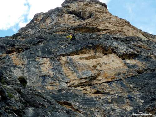
Steep wall on Nikibi |
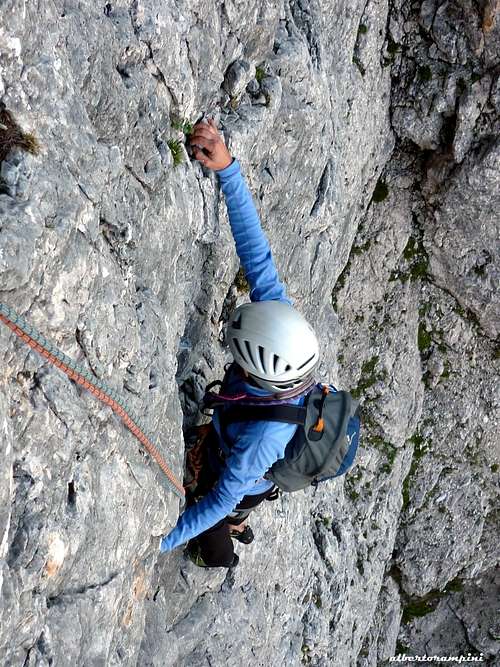
First slabs on Nikibi |
- Nikibi A beautiful moderne route on excellent rock, mainly running on slabs and little overhangs. The route is full-equipped with bolts. The starting point of the route is located in the lowest point of the wall.
L1 – Climb a slab 5a, then 4b, 40 m
L2 – Slants to left, then return right II, 20 m
L3 – Another fine grey slab, then a little overhang; belay under another little overhang. 6a, then 5a, 30 m
L4 – Climb the overhang on the right, then a slab. 6a, then 5a 35 m
L5 – Slants to right take a technical slab and climb it to a reddish wall. 5b, 30 m.
L6 – Climb directly, then traverse right to take a hard wall. Climb it. 6b+ (6a, A0), 35 m.
L7 – Another slab to a little niche, pass the niche on the right to the belay. 5b, then 6a, 40 m
L8 – Climb slants to righ, reaching an easier ridge to a belay. 6a+, then 5a, 40 m
L9 – On easier corners to the summit.
Descent: from the summit head to East (cairns) on an easy ridge to a narrow notch, then getting to the summit grassy tableland. To the left take a narrow path entering the W gully on the right (facing out) of the tower, getting the bottom.
Red Tape
There are not particular restrictions in hiking and climbing, but the whole area had been acknowledged inside UNESCO WORLD HERITAGE and requires the best care and respect. More info about Dolomiti Unesco World Heritage here:
- on Summitpost in the article by Silvia Mazzani: Dolomites living mountains
- on the Unesco Official web-site: Unesco
- on the Fondazione Dolomiti Unesco web-site: Fondazione Dolomiti Unesco

|

|
When to Climb
Best season goes from June to the end of September
Where to stay

- Rifugio Passo Giau just on the col
- Several accomodations in Cortina d’Ampezzo
Meteo
ARPAV DOLOMITI METEO
DOLOMITI METEO VENETO
DOLOMITI METEO Phone +390436780007 fax +390436780008 CENTRO VALANGHE DI ARABBA Phone +390436755711 fax 043679319 e-mail cva@arpa.veneto.it
Guidebooks and maps

Guidebooks
“IV grado e più – Dolomiti Orientali 2” by Emiliano Zorzi – Luca Brigo – Carlo Piovan Idea Montagna Ed.
“Arrampicare a Cortina d’Ampezzo e dintorni – Le vie più belle nelle Dolomiti” by Mauro Bernardi, Ed. Athesia
“Dolomiti Orientali Vol. I – Parte I” by Antonio Berti - Collana Guide dei Monti d’Italia, CAI TCI
Maps
Tabacco sheet 03 – Cortina e Dolomiti Ampezzane 1:25.000 Kompass sheet 55 - Cortina d'Ampezzo 1:50.000