
-
 1406 Hits
-
 75.81% Score
-
 6 Votes
|
|
Mountain/Rock |
|---|---|
|
|
Hiking |
|
|
Spring, Summer, Fall, Winter |
|
|
7293 ft / 2223 m |
|
|
Overview
The easternmost part of Karwendel area, bordered by Falzthurntal to the north, Stallental and Inntal to the south and west, Achensee valley to the east, offers, despite of the lower summits and the more gentle landscape, nevertheless some interesting summits. Rappenspitze, the second highest peak of that part of Karwendel area, is among them.
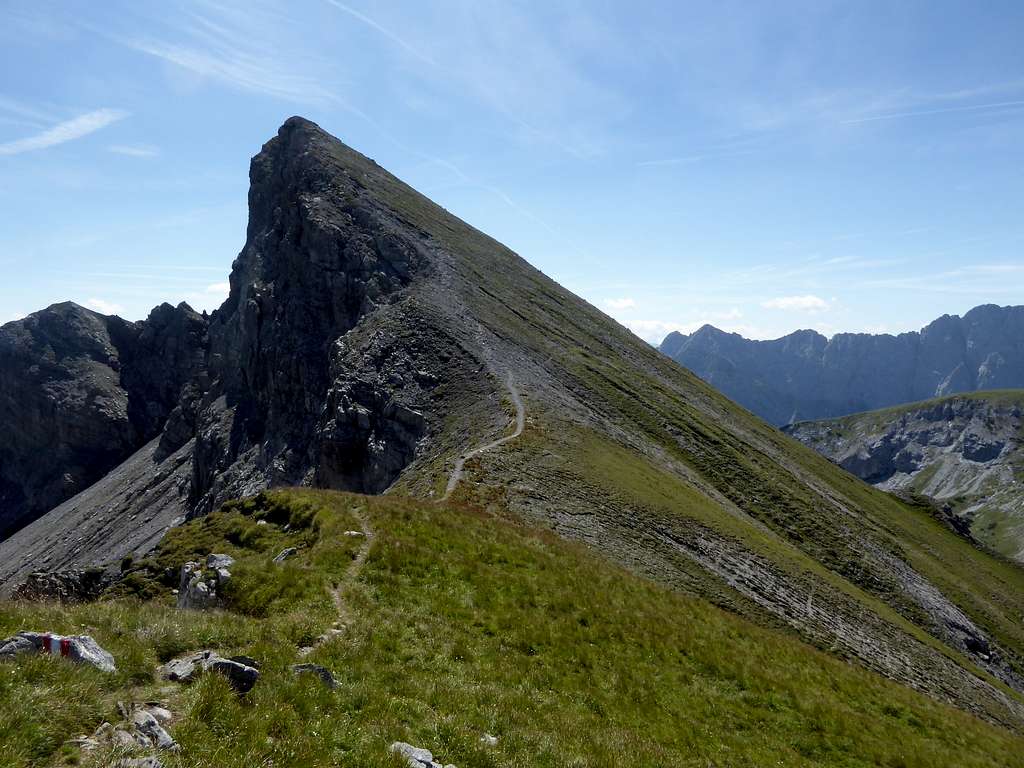
Located east of Falzthurntal between Lunstkopf to the southwest, Kaserjochspitze to the east and rock clad Dristenkopf to the north, Rappenspitze offers easy hikes and interesting traverse routes. It is an excellent lookout, too. Together with Lunstkopf, Kaserjochspitze and Stanser Joch you can create long and nice traverse routes.


Rappenspitze is a ski summit, too. Don´t underestimate a ski tour to Rappenspitze. A summer hike to this summit may be easy; the winter route is demanding and requires an experienced skier.
Getting There
Trailheads for Rappenspitze are:
- Falzthurn Alm / Falzthurn valley (toll road)
- Alpengasthof Gramai / Falzthurn valley (toll road)
- Stans / Inntal valley, parking area Bärenrast / Hinterwies


You reach these trailheads by car:
coming from Munich or Salzburg by using highways number A 8, A 93 (Germany) and then A 12 (Austria, toll road) to exit "Wiesing".
Go on road number 181 to Maurach. At the Rofan cable car follow the signs to Pertisau. At Pertisau proceed to the toll station for the "Karwendel Täler" road. At the first road junction after the toll station turn left. For Falzthurn Alm trailhead turn left at the second road junction and follow this road to its end (parking area). For Alpengasthof Gramai go straight on at this second road junction and follow that road to its end at the Alpengasthof (huge parking area).
For trailhead Bärenrast / Hinterwies exit highway A 12 at "Schwaz". Follow the signs to Fiecht. At Fiecht follow the mountain road up to parking area "Weng" and go on to parking area "Bärenrast / Hinterwies".
Public transportation to these trailheads is difficult. You find railway stations at Schwaz and at Jenbach. From Schwaz on you have to use a taxi. From Jenbach busses or the Achensee Bahn goe up to Pertisau. There is no public transportation into Karwendeltäler.
Routes Overview
Rappenspitze and Lunstkopf Trails
North Route (Ski Route)
At Falzthurnalm take trail 234 up to Dristenalm, Nauderer Kar and the summit. Beautiful ascent! Its the ski route, too. A secondary summit on the north- / northeast ridge is called "Larchkarlkopf", it is marked with a cairn.


West / South route
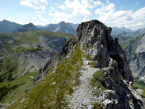
From Alpengasthof Gramai take trail number 01 in the direction to Lamsenjochhütte. After about 1 km take a trail branching off to the left (signpost "Lunstsattel") in parts steeply up to Lunstsattel. Turn left there and follow the trail to Rizuelhals and Naudersalm. Turn left again on a marked route up to Sunntiger, the col between Lunstkopf and Rappenspitze. Follow the south/southwest ridge to the summit. Some rock scramble, one step UIAA grade I.


East route from Stanser Joch
Ascent to Stanser Joch (see the SP page for this). Take trail 234 to the west, passing below Gamskarspitze and Kaserjochspitze at their south side. Descend into Nauderer Kar and take the left hand trail to Rappenspitze at the signpost.
Withe the ascent to Stanser Joch and the descent to Falzthurn Alm and Pertisau you will have a very long day.
South route
From trailhead "Bärenrast / Hinterwies" take forest road number 227 to Stallenalm. Follow trail number 227 (Nauderer Stiege) up to Rizuelhals and to Naudereralm. Proceed as described above to Sunntiger col and to the summit.
Red Tape & Accommodation
Rappenspitze belongs to Alpenpark Karwendel, an important and strictly protected National Park.
There is no entrance fee for the park but several regulations to follow.
Please respect the following rules in the National Park


Accommodation
Gear & Mountain Condition
Rappenspitze is mainly a hiking summit and therefore a summer and autumn outing. Most trails are easy, the southwest ridge requires some rock scrambling.
As a ski tour Rappenspitze is no summit for beginners. It is in parts a steep ascent and requires good ski technique. You need full ski tour and avalanche gear
Check the Tirol avalanche bulletin here.

Weather
Maps
Alpenvereinskarte, scale 1 : 25000
number 5/3, Karwendelgebirge Ost, trails, edition 2015, with UTM-grid