
-
 734 Hits
-
 74.01% Score
-
 4 Votes
|
|
Mountain/Rock |
|---|---|
|
|
47.39593°N / 11.63478°E |
|
|
Hiking |
|
|
Summer, Fall |
|
|
7028 ft / 2142 m |
|
|
Overview
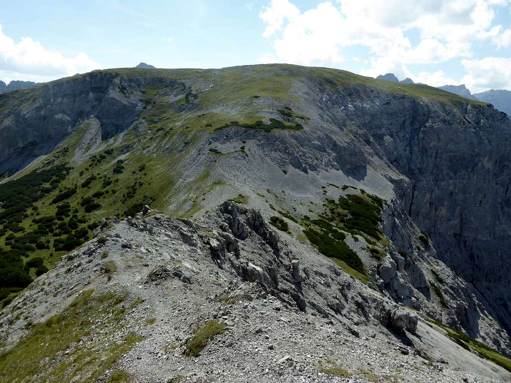
Between bold Rappenspitze and rocky - crumbly Rauher Knöll, the latter being the highest peak of this easternmost Karwendel range, you find a strange mountain. This mountain shows steep to near perpendicular rock faces down to beautiful Falzthurn valley. The summit itself is a broad, near level plateau, bordered by some dens dwarf pine "forests". Two big cairns mark the highest points of this plateau summit.
This summit is called Lunstkopf. It is a completely forgotten summit of Karwendel area, therefore you rarely will find somebody on its top. As I have a heart for those summits, I had to bag it .... As it is so lonely, many chamois are roaming the meadows and dwarf pine zones and will show their displeasure with any hiker disturbing them by snorting loud and indignantly.


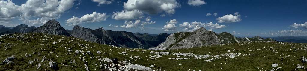
I recommend Lunstkopf with the traverse of neighbouring Rappenspitze. You best climb Rappenspitze starting at Falzthurn Alm trailhead and continue dowm Rappenspitze south ridge. Cross Sunntiger col, a real beautiful place, and climb Lunstkopf off-trail over meadow slopes and some scree. Have a long break in the sun on the summit meadows of Lunstkopf with the high Karwendel ranges just in front of you.
Getting There
Trailheads for Lunstkopf are:
- Falzthurn Alm / Falzthurn valley (toll road)
- Alpengasthof Gramai / Falzthurn valley (toll road)
- Stans / Inntal valley, parking area Bärenrast / Hinterwies


You reach these trailheads by car:
coming from Munich or Salzburg by using highways number A 8, A 93 (Germany) and then A 12 (Austria, toll road) to exit "Wiesing".
Go on road number 181 to Maurach. At the Rofan cable car follow the signs to Pertisau. At Pertisau proceed to the toll station for the "Karwendel Täler" road. At the first road junction after the toll station turn left. For Falzthurn Alm trailhead turn left at the second road junction and follow this road to its end (parking area). For Alpengasthof Gramai go straight on at this second road junction and follow that road to its end at the Alpengasthof (huge parking area).
For trailhead Bärenrast / Hinterwies exit highway A 12 at "Schwaz". Follow the signs to Fiecht. At Fiecht follow the mountain road up to parking area "Weng" and go on to parking area "Bärenrast / Hinterwies".
Public transportation to these trailheads is difficult. You find railway stations at Schwaz and at Jenbach. From Schwaz on you have to use a taxi. From Jenbach busses or the Achensee Bahn goes up to Pertisau. There is no public transportation into Karwendeltäler.
Routes Overview
Rappenspitze and Lunstkopf Trails
West / South Route
From Alpengasthof Gramai take trail number 01 in the direction of Lamsenjochhütte. After about 1 km go left on a trail (signpost "Lunstsattel") leading steeply up to Lunstsattel. Turn left there on a trail leading to Rizuelhals and to Nauderer Alm. Turn left again on the marked route to Sunntiger col between Lunstkopf and Rappenspitze. At Sunntiger turn left and climb a scree slope to meadow slopes leading up to the summit.
Alternatively climb the steep dwarf pine clearings near Lunstsattel on the south side of the mountain. First straight up and then more to your right you will reach the summit off-trail. See the map below.
Another off-trail route is the ridge, starting at Rizuelhals.


East Route
Ascend to Stanser Joch. Take trail number 234 from there passing below Gamskarspitze and Kaserjochspitze at their south side. At the trail junction shortly before trail number 234 descends into Nauderer Kar take the left hand trail down to Nauderer Alm. Use the route to Sunntiger and to the summit, alternatively the route from Rizuelhals to the summit.
South Route
From trailhead "Bärenrast / Hinterwies" take forest road number 227 to Stallenalm. Follow trail number 227 (Nauderer Stiege) up to Rizuelhals and to Naudereralm. Proceed as described above to Sunntiger col and to the summit.


Recommended Traverse Route Rappenspitze - Lunstkopf
Falzthurnalm - trail 234 to Rappenspitze - southwest ridge to Sunntiger - northwest slopes to Lunstkopf - southest slopes to Lunstsattel - trail to Alpengasthof Gramai - trail 01 back to Falzthurnalm
Red Tape & Accommodation
Red Tape
Lunstkopf belongs to Alpenpark Karwendel, an important and strictly protected National Park.
There is no entrance fee for the park but several regulations to follow.
Please respect the following rules in the National Park


Accommodation
Gear & Mountain Condition
Lunstkopf is a hiking summit and therefore a summer and autumn outing. Most trails and routes are easy, the summit routes are off-trail, the south slopes are steep and if you don´t keep to the dwarf pine clearings there will be some bush wacking ....
Weather
Map
Alpenvereinskarte, scale 1 : 25000
number 5/3, Karwendelgebirge Ost, trails, edition 2015, with UTM-grid