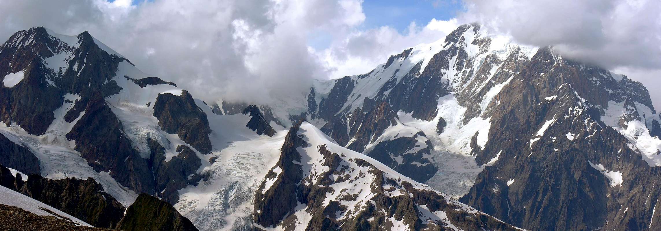
Situated immediately to the East of the Aiguille of Trélatête on a rocky spur, that the same "gives birth" to Southeast and ending after the beautiful peaks of Petit Mont Blanc (3.424m), with the two peaks of the parallel Mount Tseuc and Aiguille de Combal (to the West), rocky cliffs that plunge over Lake Combal (1.950 meters). To the east a high cliff falls with more than 1.000 meters in altitude up to the very big Miage Glacier, engraved by a steep snowy gully that climbs up to the small saddle between the Petit Mount Blanc and the Aiguille, and another just North and parallel to the previous one reaches wider saddle snowy in the North of the Peak. In the West it is instead surrounded by Petit Mount Blanc Glacier, which rises to the Summit of the Aiguille of Trélatête (3.920m). From Lake Combal the rough trail that leads to the Bivouac Gino Rainetto/Giovane Montagna or of the Petit Mount Blanc. Beautiful shots of an eye to the vast Northeast Southwest Slope of Mount Blanc and the surrounding West's three Summits Trélatete and, a little further on in the Southwest, the Aiguilles of the Lex Blanche and the nearby Aiguille des Glaciers.
Situata subito ad Oriente dell'Aiguille de Trélatete su di un contrafforte roccioso, che la medesima "partorisce" a Sudest terminante, dopo la bella cima del Petit Mont Blanc (3.424 m), con le due vette parallele del Mont Tseuc e dell'Aiguille de Combal (ad Ovest), alte e rocciose e precipitanti sopra il Lago di Combal (1.950 m~). Ad Est un'alta parete rocciosa scende con oltre 1.000 m di dislivello fino al grandissimo Ghiacciaio del Miage, incisa da un ripido canalone nevoso che sale fino a raggiungere la piccola sella tra l'Aiguille ed il Petit Mont Blanc; un altro subito a Nord, e parallelo al precedente, raggiunge un'altra più larga sella nevosa a Settentrione della Vetta. Ad Occidente è invece circondata dal Ghiacciaio del Petit Mont Blanc, che sale fino alla Sommità dell'Aiguille de Trélatete (3.920 m). Dal Lago Combal risale il rude sentiero apportante al Bivacco Gino Rainetto/Giovane Montagna o del Petit Mont Blanc. Ottimo panorama a Nordest sul vasto Versante Sudovest del Monte Bianco ed a Ovest sulle vicine tre Sommità della Trélatete e, poco più in là a Sudovest, sull'Aiguilles de la Lex Blanche e sulla vicina Aiguille des Glaciers.
First Ascents
First in the summit: Agostino Ferrari with the two Mountain Guides of Courmayeur Laurent Bertholier and Felix Ollier, Aug 18th, 1898.
In winter: Unknown.
Getting There
BY CAR:
From Torino, Milano, etc: Motorway A5. Exit at Courmayeur.
From Switzerland: through the Grand St. Bernard Tunnel or the homonym pass.
From France: through Mont Blanc Tunnel or Petit St. Bernard Pass.
BY PLANE:
Aeroporto "Corrado Gex" Saint Christophe (Aosta).
Approach
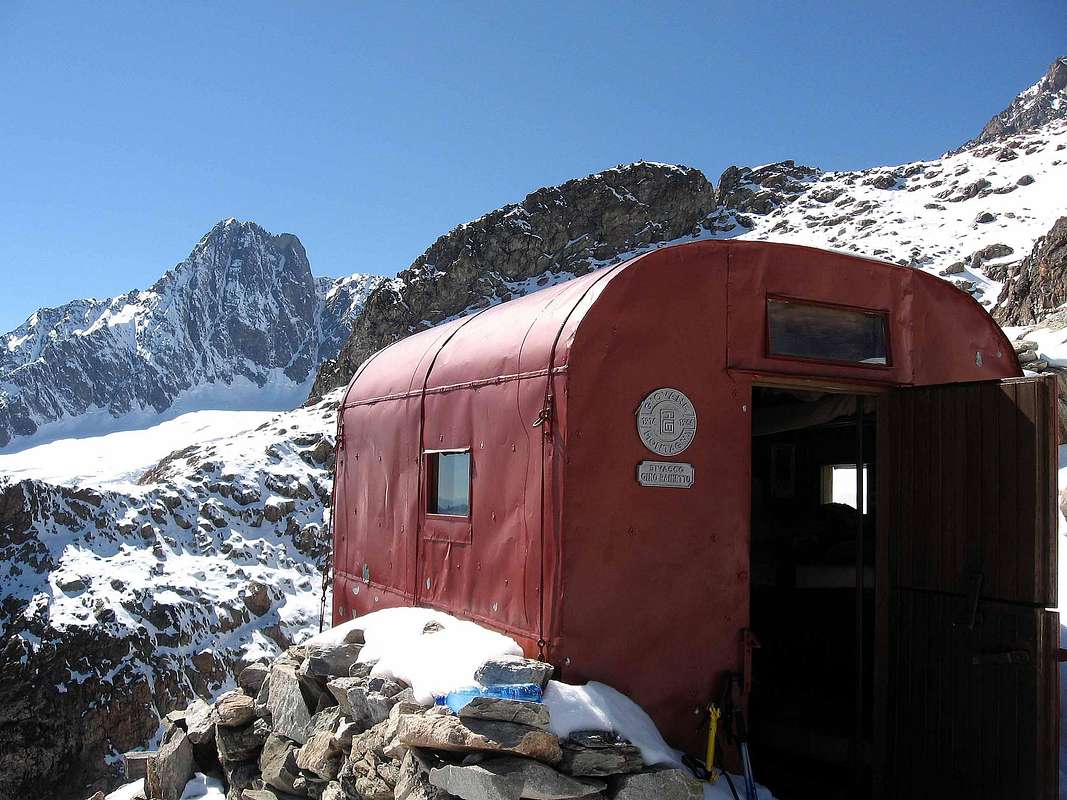
From the street "farm" for the Rifugio Elisabetta (prohibition to transit through iron gate barrier), continue along the same to the junction to the Bar Combal; continue with the path n° 18, leaving to the left the way to the shelter, catching up. From this, situated between the two lakes Miage and Combal, continue, leaving the right one that dates back to Miage, first to the north-northwest and then decidedly to the west reaching the mouth of the valley between the Tseuc and Mont Aiguille de Combal. Traced between moraines, and finally on polished rocks by ice, to the Bivouac Rainetto/Giovane Montagna (3.047m; 3h'00/3h'30).
Dalla strada "poderale" per il Rifugio Elisabetta (divieto di transito con sbarramento tramite cancello in ferro), proseguire sulla medesima fino al bivio per il Bar Combal; continuare con il sentiero n° 18, lasciando a sinistra la via per il rifugio, raggiungendolo. Da questo, situato tra i due Laghi del Miage e di Combal, continuare, lasciando a destra quello che risale al Miage, dapprima a Nord-nordovest e poi decisamente ad Ovest raggiungendo l'imbocco del vallone tra il Mont Tseuc ed l'Aiguille de Combal. Risalire tra morene, ed infine su rocce levigate dai ghiacci, fino al Bivacco Rainetto/Giovane Montagna (3.047 m; 3h'00/3h'30).
Route
In the first part of itinerary, from the bivouac continue to climb to the crest and through a long snowy hump (sometimes icy) reach the Top of Petit Mont Blanc (3.424m), passing in the final stretch a small crevasse, sometimes not always easy and, in general, going around to the right (East; see pictures; (1h'15/1h'30; total 4h'30/5h'00). In the second, get down on easy rock for about seventy meters to the narrow carving between this and the Aiguille de l'Aigle (rooms where a large and snowy couloir from the below Miage Glacier with a vertical drop of over 1.000 meters) formed by a small and snowy saddle that runs to the North. Easily, but always on rocks exposed to the East, quickly reach the Aiguille along the Slope South-southeast that then up, turns into Crest South. The climb takes place on large blocks and square blackish, sometimes overlapping, and requires caution in the event of snow, "verglass", or just with conditions changing weather and poor visibility relative (1h'15/1h'30, in total 5h'30/6h'00).
Nella prima parte dell'itinerario, dal bivacco continuare a salire raggiungendo la cresta spartiacque e tramite una lunga gobba nevosa (a volte ghiacciata) raggiungere la cima del Petit Mont Blanc (3.424 m), superando nel tratto finale una piccola crepaccia, a volte non sempre facile ed, in genere, aggirandola a destra (Est; vedi foto; 1h'15/1h'30; in totale 4h'30/5h'00). Nella seconda, scendere su facili rocce per una settantina di metri allo stretto intaglio tra questo e l'Aiguille de l'Aigle (dove sale un canalone nevoso dal Ghiacciaio del Miage con un dislivello di oltre 1.000 metri), formato da una selletta nevosa, che si percorre verso Settentrione. Sempre su rocce facili, ma esposte ad Est, raggiungere in breve tempo l'Aiguille lungo il versante Sud-sudest che poi, progredendo, si tramuta in Cresta Sud. La salita avviene su grandi blocchi nerastri e squadrati, a volte sovrapposti, e richiede prudenza in caso di neve fresca, "verglass" o, semplicemente, con condizioni di mutare del meteo e relativa scarsa visibilità (1h'15/1h'30; in totale 5h'30/6h'00).
Difficulty
Difficulty: F+/PD-.
Difficoltà: F+/PD-.
Gear
Mountaineering equipment, including rope, iceaxe, and crampons.
Da alta montagna, corda, picozza e ramponi.
Huts
Bivacco GINO RAINETTO(3.047m)
Campings
Remember that free camping is forbidden (except for emergency reasons, over 2.500m, from darkness until dawn).
When To Climb
The period from mid June to mid September usually offers the best conditions. The rock climbs would be substantially more challenging of season.
Mountain Conditions
You can get meteo information at the official site of the Regione Valle d'Aosta:
Parents refers to a larger category under which an object falls. For example, theAconcagua mountain page has the 'Aconcagua Group' and the 'Seven Summits' asparents and is a parent itself to many routes, photos, and Trip Reports.

 9829 Hits
 87.75% Score
 25 Votes