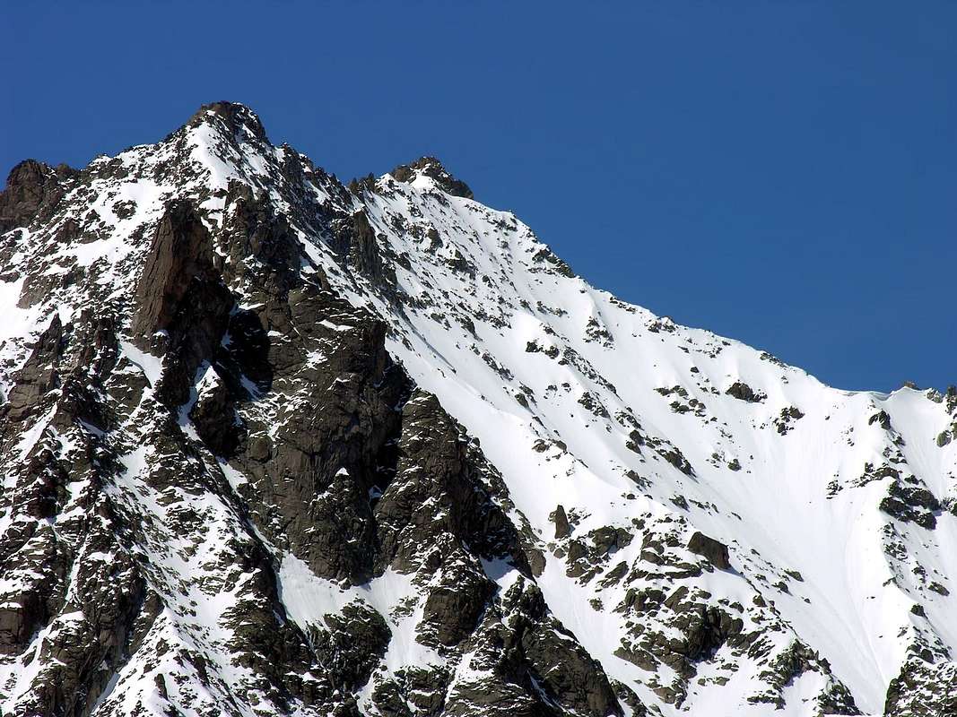
Beautiful pyramid, perfectly triangular when seen from the north. It has two summits, of which the northern one is taller. On its NW spur two other peaks rise, named after Michel and Alphonse Payot. Great views of the Mont Blanc range, especially of the Aiguilles des Chamonix and of the ridge that includes Dent du Géant, Rochefort, and Grandes Jorasses.
Bella piramide triangolarmente perfetta se vista da nord. E' costituita da due cime, della quali la Nord è la più elevata. Sul suo sperone NW si innalzano altre due vette dedicate a Michel e Alphonse Payot. Grandi viste sulla Catena del Monte Bianco con colpi d'occhio eccezionali sulle Aiguilles des Chamonix e sulla Cresta Dente del Gigante, Rochefort e Grandes Jorasses.
First Ascents
Punta Nord:
First in the summit (from NE Slope): Lionel Dècle, Henry Devouassod Edouard Coupelin, (Aug 17th, 1876).
In winter from Rochefort Pass and E Arête: G. Carugati, miss Carugati, Joseph Petigax and Laurent Petigax, (Jan 21th, 1907), in descent.
S Arête (from Cima Sud): P. Reuchel, solo, (Aug 04th, 1908), in descent.
WS Slope (from Colle del Gigante): Agostino Ferrari, Joseph Petigax and Fabien Croux, (Sep 07th, 1896).
NE Slope: Lionel Dècle, Henry Devouassod Edouard Coupelin, (Aug 17th, 1876).
Punta Sud:
First in the summit (from Colle del Gigante and E Arête): A. Hess, O. Leitz and Laurent Croux, (Jul 22th, 1898).
In winter: Unknown.
S Arête (from Colle del Gigante): P. Reuchel, solo, (Aug 04th, 1908), in descent.
W Wall: Unknown.
Getting There
BY CAR:
From Torino, Milano, etc: Motorway A5. Exit at Morgex.
From Switzerland: through the Grand St. Bernard Tunnel or the homonym pass.
From France: through Mont Blanc Tunnel or Petit St. Bernard Pass.
From A5 Morgex toll drive along the SS.26 toward Courmayeur, cross it and once in Entréves follow for the Village La Palud - car parking car parking - Funivies of the Monte Bianco.
Dall'uscita dell'Autostrada A5 nel comune di Morgex (921 m) proseguire lungo la SS.26, verso il Paese di Courmayeur (1.228 m) e, raggiunta la Frazione di Entrèves/La Palud (1.370 m), parcheggiare l'auto nel parcheggio delle "Funivie del Monte Bianco".
Route
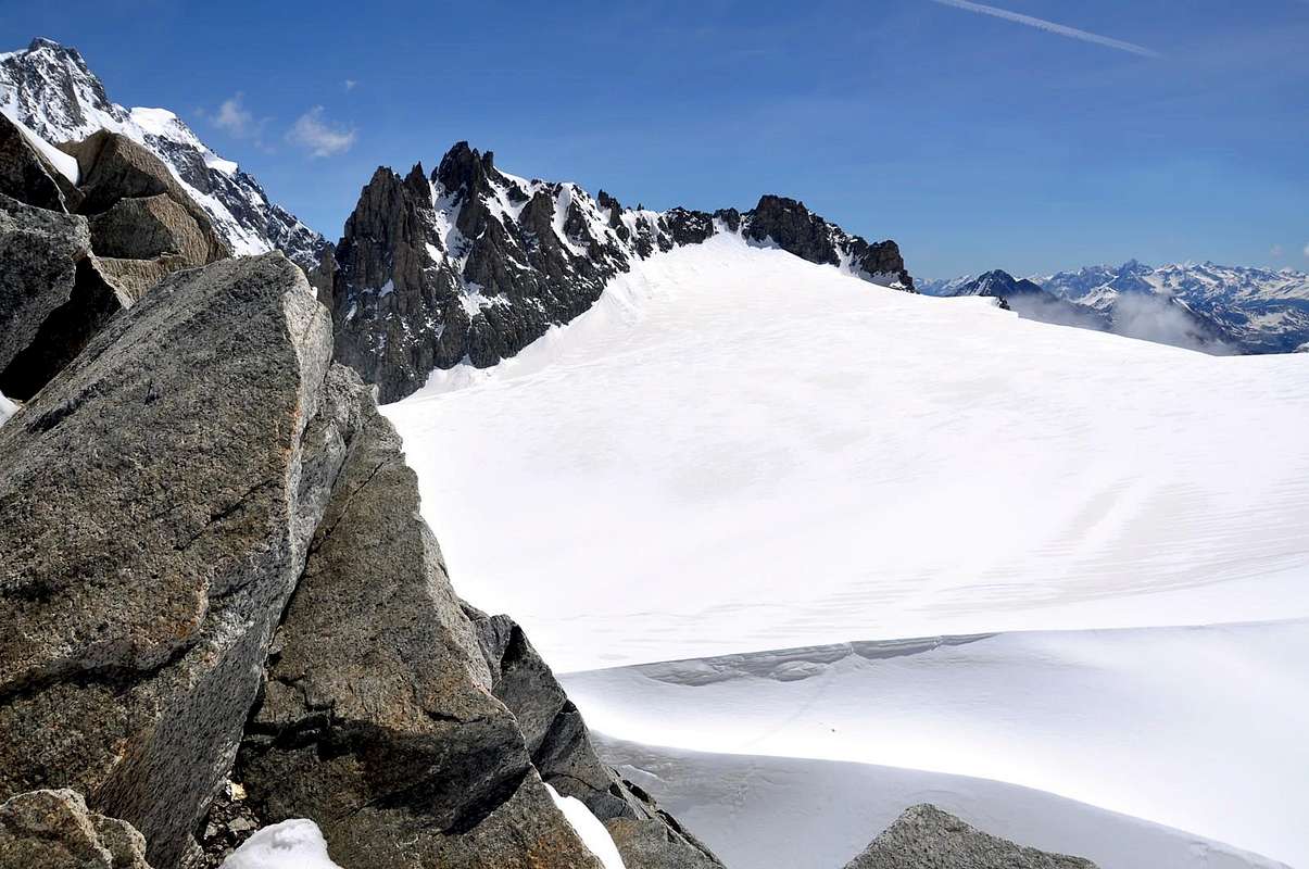
From the arrival of Punta Helbronner cablecar (3.462m) go down until Colle del Gigante (3.365m) and then down on the Gèant Glacier, following the direction of altitude (3.331m) to the base of NW Punta Nord spur (via del Dente); lap this spur and go up to the Colle di Rochefort (3.387m). Climb easily the East crest, triyng to avoid some block in the southern part or run across all the crest (II°).
Dall'arrivo della funivia di Punta Helbronner (3.462 m) scendere al Colle del Gigante (3.365 m) e sempre perdendo leggermente dislivello scendere su Glacier du Géant in direzione della quota (3.331 m) alla base dello sperone NW della Punta Nord (via del Dente); doppiarlo e risalire al Colle di Rochefort (3.387 m). Arrampicare abbastanza facilmente la cresta E di confine, evitando a sud qualche blocco oppure percorrerla integralmente (II°).
Difficulty
Difficulty: F+/PD-.
Difficoltà: F+/PD-.
Gear
Mountaineering equipment, including rope, iceaxe, and crampons.
When To Climb
The period from mid June to mid September usually offers the best conditions. The rock climbs would be substantially more challenging off season.
Tel.: Nuovo numero telefonico +39 3402270121 Cell. Gestore +39 3356184758 Funivie Monte Bianco +39 016589925
Red Tape
No permits are required and no fees must be paid to climb Aiguilles Marbrées. Since it is on the Italian-French border, carry some means of identification.
Campings
Remember that free camping is forbidden (except for emergency reasons, over 2.500m, from darkness until dawn).
Mountain Conditions
You can get meteo information at the official site of the Regione Valle d'Aosta:
"Guida delle Alpi Occidentali", di Giovanni Bobba e Luigi Vaccarone C.A.I. Sezione di Torino Volume II (parte II), 25 Maggio 1896.
"Guida dei Monti d'Italia-Monte Bianco" (Vol.II°) di R. Chabod, L. Grivel, S. Saglio, G. Buscaini-Club Alpino Italiano/Turing Club Italiano, 1968 (in Italian).
"I Rifugi della Valle d'Aosta" di Stefano Ardito, Ed. Guide iter, Febbraio 2003.
"A piedi in Valle d'Aosta" (Vol.1), di Stefano Ardito, Ed. Guide iter, Giugno 2003.
"80 itinerari di Escursionismo Alpinismo e Sci Alpinismo in Valle d'Aosta", di Osvaldo Cardellina, Ed. Musumeci, Giugno 1977 (in Italian); seconda Ed. Luglio 1981; terza Ed. Luglio 1984; (in French), prima Ed. Febbraio 1978; seconda Ed. Marzo 1980.
MAPS:
Kompass "Massiccio del Monte Bianco Valle d'Aosta Sentieri e Rifugi" Carta turistica 1:50.000.
I.G.C. Istituto Geografico Centrale Torino "Massiccio del Monte Bianco" (n° 4), Torino, 1998 1:50.000.
I.G.C. Istituto Geografico Centrale Torino "Monte Bianco-Courmayeur-Chamonix-La Thuile" (n° 107), 1:25.000.
Parents refers to a larger category under which an object falls. For example, theAconcagua mountain page has the 'Aconcagua Group' and the 'Seven Summits' asparents and is a parent itself to many routes, photos, and Trip Reports.

 14348 Hits
 85.87% Score
 21 Votes