
-
 10992 Hits
-
 89.39% Score
-
 29 Votes
|
|
Mountain/Rock |
|---|---|
|
|
45.53060°N / 7.15347°E |
|
|
Mountaineering |
|
|
11253 ft / 3430 m |
|
|
Overview
This is the last, and the northernmost, summit of the ridge made of three summits (Taou Blanc - l'Aouille - Cima di Entrelor) dividing the Val di Rhemes (W) from the Valsavarenche (E). This summit is very frequented in spring for its ski-mountaneering route.
Ultima vetta a nord (la più importante perché frequentata in primavera da molti sciatori), delle tre punte Taou Blanc - l'Aouille - Entrelor che sorgono sulla cresta divisoria fra la Val di Rhemes (a ovest) e la Valsavarenche (a est).
First Ascents
- N Arête: P. Puiseux and L. Boutan, (Aug 14th, 1877).
- S-W Arête: W. A. B. Coolidge and Christian Almer, (Aug 23th, 1885), in ascent.
- S-W Arête: W. A. B. Coolidge and Christian Almer, (Aug 23th, 1885), in descent.
- N-W Arête: Giovanni Bobba and Casimiro Thérisod, (Jul 18th, 1888).
Getting There
BY CAR:
- From France: through the Mont Blanc Tunnel or the Col du Petit Saint Bernard: you can drive on SS.26, following directions for Aosta and, before arriving in Villeneuve, turn right toward Introd. Alternatively, you can take motorway A5 (at Courmayeur or Morgex) and exit at Aosta Ovest.
- From all the other directions: get to the Aosta Ovest exit of motorway A5. Then drive on SS.26 Aosta, in the direction of Courmayeur; just after Villeneuve turn left toward Introd. Shortly after Introd, you arrive at a junction: turn left, entering Valsavarenche, and passing through many villages (Degioz, Eaux Rousses, etc.) you can arrive at Pont (1.978m) where the road ends.
BY PLANE:
- Aeroporto "Corrado Gex" Saint Christophe (Aosta).
Route from Valsavarenche
From Pont Valsavarenche (1.978m), along the road of Colle del Nivolé. After passing some hairpin bends and a tunnel go on along the road till the confluence of the Valley of Mejes. Now along this steep valley, keeping the right side (ascending) up to the mountain Pasture Mejes di Sopra or d'en Haut (2.510m).Here the slopes become sweeter and, keeping first the right part then the left one, ascend to the bottleneck bringing to the Glacier of Percià. On, along the central part of the glacier (warning crevasses) then, turn to the right to gain the main ridge between Val Di Rhemes and Valsavarenche. Cross the Point (3.397m) and follow along the slopes bringing to the summit. Descent along the same route or, along the ski-mountaneering route, toward the Val di Rhemes. Time required for the ascent: 5h'00/6'00.
Da Pont di Valsavarenche (1.978 m) risalire il tracciato della strada che conduce ai piani del Colle Nivolé. Dopo aver superato alcuni tornanti e un tunnel continuare lungo la strada sino alla confluenza del Vallone delle Mejes, imboccare il ripido vallone tenendosi sulla destra fino a sbucare all'Alpeggio Mejes di Sopra o d'en Haut (2.510 m). Qui il percorso diventa più pianeggiante continuare tenendosi prima sulla destra e poi sulla sinistra, si risale una strettoia che porta sul Ghiacciaio di Percià. Risalirlo al centro facendo attenzione ai crepacci per poi spostarsi sulla destra sino a raggiungere lo spartiacque con la Valle di Rhêmes. Oltrepassare la Quota (3.397 m) e risalire il pendio che conduce alla vetta. Discesa lungo la via di salita o altrimenti in Valle di Rhêmes. Tempo di salita 5h'00/6h'00.


|
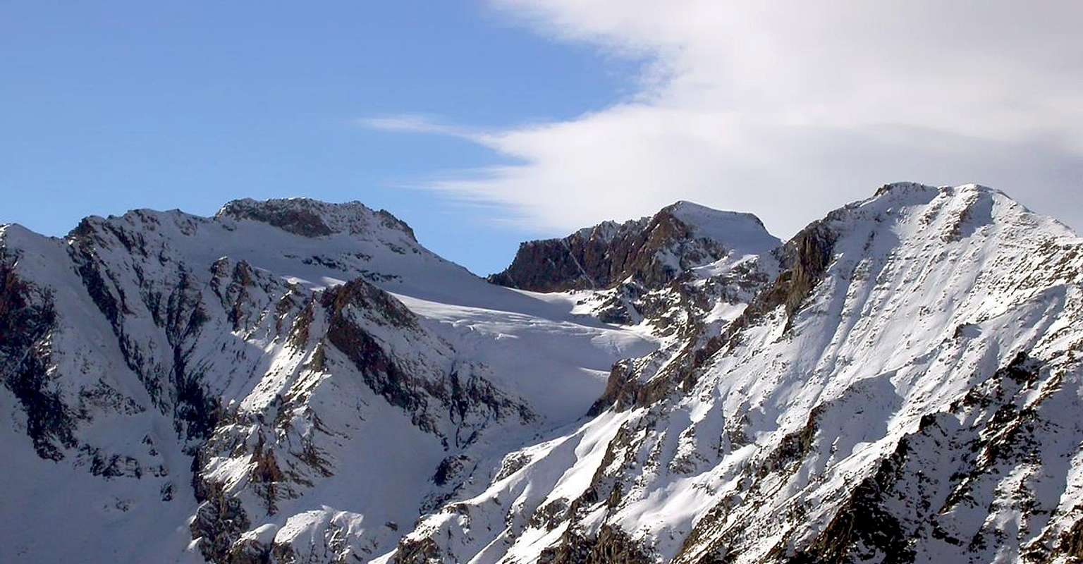
Western view from Cima di Entrelor (photos by besucher01) of Gran Paradiso range, starting from La Grivola, on the left, including Gran Serz, Herbetet, Becca di Montandaynè, Piccolo Paradiso, Gran Paradiso, Becca di Moncorvè, Tresenta, Ciarforon, Becca di Monciair and ending with Denti del Broglio, on the right. Also Punta Fourà, Taou Blanc in the foreground (and Levanne in the background) are recognizable.
|
Difficulties
The rating is Easy (hiking) or BS (ski-mountaneering).
L'itinerario è classificato F (facile). Per la sci alpinistica la classificazione è Buoni Sciatori.

|

|
Equipment
Mountaineering equipment including rope, and crampons.

|

|
Campings
Remember that free camping is forbidden (except for emergency reasons, over 2.500m, from darkness until dawn).
Mountain Condition
- You can get meteo information at the official site of the Regione Valle d'Aosta:
- Valle d'Aosta Meteo
- Meteo: You can find more weather information on the website 3B Meteo:
- Meteo Rhemes Notre Dame
Webcam
- WEBCAM on Aosta Valley:
- Webcam
Books and Maps
BOOKS:
- "Guida delle Alpi Occidentali", di Giovanni Bobba e Luigi Vaccarone C.A.I. Sezione di Torino Volume II (parte II), 25 Maggio 1896.
- "Scialpinismo in Valle d'Aosta", di Pietro Giglio e Emile Noussan. Musumeci Editore, 1993.
- "80 itinerari di Escursionismo Alpinismo e Sci Alpinismo in Valle d'Aosta", di Osvaldo Cardellina, Ed. Musumeci, Giugno 1977 (in Italian); seconda Ed. Luglio 1981; terza Ed. Luglio 1984; (in French), prima Ed. Febbraio 1978; seconda Ed. Marzo 1980.
- "Guida dei Monti d'Italia-Gran Paradiso Parco Nazionale" E. Andreis, R. Chabod, M. C. Santis, Club Alpino Italiano/Touring Club Italiano, prima Ed. 1939; seconda Ed. 1963; terza Ed. 1980.
- "La Cima di Entrelor", di Renato Chabob, Ed. Zanichelli, Bologna, 1969.
- "Valle d'Aosta in Sci", di Rosanna Carnisio, Silvana e Guido Albertella, Ed. CDA Torino, 1993.
- "La Valle di Rhêmes" di Lorenzo Rossi di Montelera, Ed. Tamari, Bologna, 1978.
- "Gran Paradiso", G. Klotz, Ed. Bergverlag GmbH Rother, Monaco 2005 (in tedesco).
- "Escursioni in Valsavarenche", di Giovanni Canziani e Carlo Colnago, Ed. Tamari, Bologna, 1982.
- "Pelli di Foca in Valle d'Aosta", di Franco Lenzi Editoriale Pedrini Torino, 1988.
 |
 |
 |
 |
 |
MAPS:
- Kompass "Gran Paradiso Valle d'Aosta Sentieri e Rifugi" Carta turistica 1:50.000.
- L'Escursionista Ed. Carta dei Sentieri "Valgrisenche/Val di Rhêmes" (carta n° 3) 1:25.000.
- Enrico Editore Ivrea-Aosta "Gruppo del Gran Paradiso" 1:50.000.
- I.G.C. Istituto Geografico Centrale, Torino "Il Parco Nazionale del Gran Paradiso" (carta n° 3) 1:50.000.
Important Information
- REGIONE AUTONOMA VALLE D'AOSTA the official site.
- FONDAZIONE MONTAGNA SICURA Villa Cameron, località Villard de la Palud n° 1 Courmayeur (AO) Tel: 39 0165 897602 - Fax: 39 0165 897647.
- SOCIETA' GUIDE ALPINE DEL GRAN PARADISO Comune di Valsavarenche.
- A.I.NE.VA. (Associazione Interregionale Neve e Valanghe).
Useful phone numbers
- Protezione Civile Valdostana località Aeroporto n° 7/A Saint Christophe (Ao) Tel. 0165-238222.
- Bollettino Meteo (weather info) Tel. 0165-44113.
- Unità Operativa di Soccorso Sanitario Tel. 118.
Acknowledgements
In addition I want to thank Gabriele Roth for the translation of the text from italian.