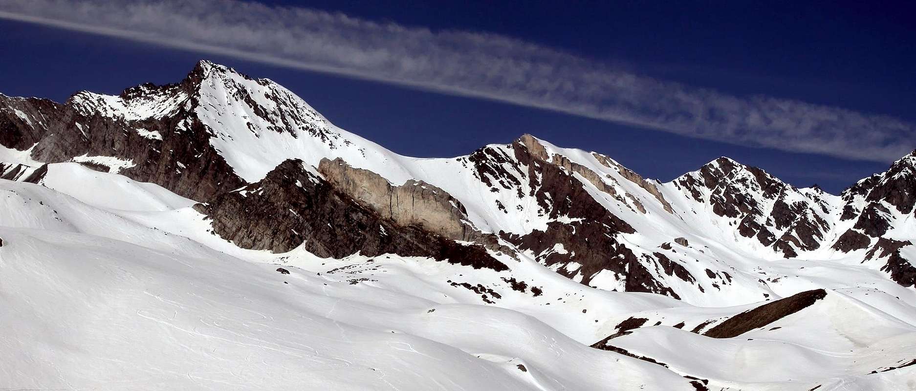
Fine summit, then "stifled" by rocky pyramids of the Grivola and Bianca, Nera, Rossa Points in the North. In South the great spur from Gran Sertz also Serra, Herbetet and Gran Paradiso to diminue in impressiveness ad importance. Good views on the Grivola, Herbetet and Gran Paradiso. Longs approachs, but panoramics, from Eaux Rousses in Valsavarenche and from Valnontey in Cogne Valley.
Bella punta rocciosa, ma "oscurata" dalle piramidi della Grivola, Punta Bianca, Nera e Rossa a Nord, mentre a Sud è la grande costiera che dal Gran Sertz o Serra risale all'Herbetet e al Gran Paradiso a farle perdere d'imponenza nonché importanza. Belle viste sul gruppo della Grivola e stupende sul vicino Herbetet. Lungo l'avvicinamento, ma panoramico, da Eaux Rousses in Valsavarenche o da Valnontey in Valle di Cogne.
First Ascents
First on the summit: P. Paganini and E. Jeantet, (Jul 28th, 1881).
First in winter: Unknown.
NW Face (from Eaux Rousses): Osvaldo Cardellina, solo (Sep 08th, 1996), in day from Eaux Rousses.
N-NE Arête: P. Paganini and E. Jeantet, (Jul 28th, 1881).
N-NE Arête (from Eaux Rousses; integral): Osvaldo Cardellina, Nicola Colajanni and Gianfranco Vicentini, (Aug 13th, 2000), in day from Eaux Rousses.
SE Arête: George Yeld and mountain guide of Valtournenche Beniamino and A. Pession, (Aug 12th, 1911).
Getting There
BY CAR:
From Torino, Milano, etc: Motorway A5. Exit at Aosta Ovest. Drive to the near Aymavilles. Follow the directions for Valle di Cogne or Valsavarenche.
From Switzerland: through the Grand Saint Bernard Tunnel or the namesake Pass. Drive to Aosta, then follow the direction for Courmayeur on SS.26. Just after Sarre, turn to the left, in the direction of Valle di Cogne or Valsavarenche.
From France: through Mont Blanc Tunnel or Petit St. Bernard Pass. It isn't necessary to take Motorway A5: you can drive on SS.26, in the direction of Aosta. Before arriving at the Village of Sarre, turn right following the sign for Valle di Cogne or Valsavarenche. After Aymavilles, the SR.47 crosses the Villages of Vieyes, Epinel and Cretaz and after about 25 Km arrives at Cogne (1.534m). From Cogne you can get the Village of Valnontey (1.666m).
From Valsavarenche: Shortly after Introd, you arrive at a junction: turn left, entering Valsavarenche, and passing through many Villages (Degioz, Eaux Rousses).
BY PLANE:
Aeroporto "Corrado Gex" Saint Christophe (Aosta).
Route
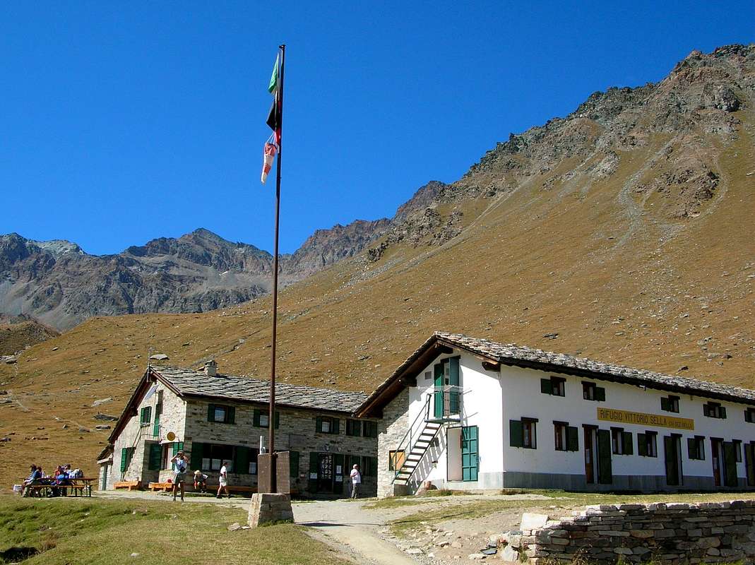
(A) FROM COGNE VALLEY: From Valnontey (1.666m), a small Village South of Cogne, along a comfortable muletrack starting from the meadows once crossed the bridge you can get the Rifugio Vittorio Sella (2.584m) placed in a wide plain near the Loson Torrent. From the Refuge follow the valley trail n° 18 (Alta Via n° 2), North of the Torrent Grand Lauson, that with a final steep section and then exposed to a crossing from Northeast in the Southwest reached Col Lauson (3.296m) and hence the Summit. See route (B) (5h'00/6h'00 from Valnontey).
(A) DA COGNE: Da Valnontey (1.666 m), Frazione di Cogne, salire al Rifugio Vittorio Sella (2.584 m), situato in un ampio pianoro, presso il Torrente Gran Loson. Il rifugio si raggiunge seguendo la comoda mulattiera che si stacca dai prati al di là del ponte. Dal rifugio seguire sul fondovalle il sentiero n° 18 (Alta Via n° 2), a Nord del Torrente Grand Lauson, che con un tratto finale ripido e infine una traversata esposta da Nordest a Sudovest raggiunge il Colle Lauson (3.296 m) e da qui la Vetta, come da itinerario B (5h'00/6h'00 da Valnontey).
(B) FROM VALSAVARENCHE: From Eaux Rousses (1.665m) to cross the bridge in Savara Torrent and to take the good Royal muletrack (roadsigns) by signals (10b) and (Alta Via n° 2) to reach the "Casotto" (Gamepaeker House) of the Lover Leviona (2.285m), near Levionaz Torrent to catch of the Middle Levionaz (2.366m) and following crossroads (2.581m). To return in climb to the Northeast direction and by wides windings roads until Lauson Pass (3.296 m) to cross a first pinnacle 25/30 meters (II°+/III°-; also called by an balcony in West I°+) high Edge but by rocks friables not much steep (I°) in the Summit (5h'00/6h'00 from Eaux Rousses).
(B) DA VALSAVARENCHE: Da Eaux Rousses (1.665 m) attraversare il Torrente Savara e prendere la bella mulatiera Reale (cartelli) con segnalazioni (10b) e (Alta Via n° 2). Raggiungere il Casotto P.N.G.P. di Leviona di Sotto (2.285 m), presso il Torrent de Levionaz. Cambiando direzione da Nordest in Sudest raggiungere Levionaz di Mezzo (2.366 m) e il successivo bivio (2.581 m), dove si torna a salire in direzione Nordest fino al Colle Lauson (3.296 m). Risalire la Cresta Nord-nordest superando un gendarme di 25/30 metri (II°+/III°-; oppure aggirandolo su una cengia ad Ovest I°+) e su rocce rotte (I°) sino alla Vetta (5h'00/6h'00 da Eaux Rousses).
Difficulties
The route is for Expert Hikers or for Mountaineers, in integral.
L'itinerario è classificato EE/F; PD+ in integrale.
Within the borders of the P.N.G.P. (Parco Nazionale del Gran Paradiso), at the moment (summer 2004), dogs generally are not allowed, except on a couple of trails, and camping is forbidden (except for climbers from sunset till dawn). No fees are due.
Books and Maps
BOOKS:
"Guida dei Monti d'Italia-Gran Paradiso Parco Nazionale" E. Andreis, R. Chabod, M. C. Santis, Club Alpino Italiano/Touring Club Italiano, prima Ed. 1939; seconda Ed. 1963; terza Ed. 1980.
"I Rifugi della Valle d'Aosta" di Stefano Ardito, Ed. Guide iter, Febbraio 2003.
"Parco Nazionale del Gran Paradiso" di Stefano Ardito, Ed. Guide iter, Novembre 2001.
"Guida delle Alpi Occidentali", di Giovanni Bobba e Luigi Vaccarone C.A.I. Sezione di Torino Volume II (parte II), 25 Maggio 1896.
"Diari Alpinistici" di Osvaldo Cardellina e Indice Generale accompagnato da Schedario Relazioni Ascensioni 1964-2019 (inediti).
"Rifugi e bivacchi in Valle d'Aosta", di Cosimo Zappelli aggiornata da Pietro Giglio, Musumeci Editore, Luglio 2002.
"Il Parco Nazionale del Gran Paradiso (Valli di Champorcher-Clavalitè-Saint Marcel-Laures-Cogne-Valsavarenche-Conca di Pila" di Giulio Berutto 3/volume 2°, I.G.C., Torino 1981, 2a Ed. 2000. (in Italian).
"Pelli di Foca in Valle d'Aosta", di Franco Lenzi Editoriale Pedrini,Torino 1988.
"Gran Paradiso itinerari escursionistici" di Franco Brevini, Ed. Musumeci, Luglio 1982.
MAPS:
Kompass "Gran Paradiso Valle d'Aosta Sentieri e Rifugi" Carta Turistica 1:50.000.
Enrico Editore Ivrea-Aosta "Gruppo del Gran Paradiso" 1:50.000.
L'Escursionista "Valle di Cogne Carta dei Sentieri" 1:25.000.
L'Escursionista "Tour de la Vallée de Cogne Grand Paradis" 1:25.000.
I.G.C. Istituto Geografico Centrale "Parco Nazionale del Gran Paradiso" 1:50.000.
Parents refers to a larger category under which an object falls. For example, theAconcagua mountain page has the 'Aconcagua Group' and the 'Seven Summits' asparents and is a parent itself to many routes, photos, and Trip Reports.

 7000 Hits
 84.27% Score
 18 Votes