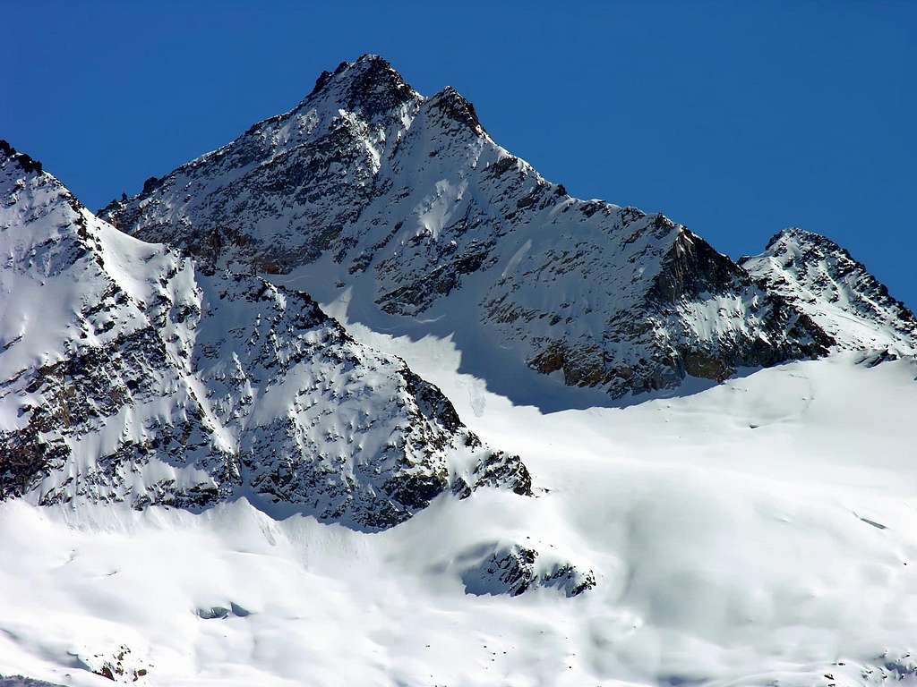
Smart triangular mountain, twin of the nearby Punta di Forzo (3.252m), in full sight from Gimillan (1.787m), just above Cogne and along the road leading to Lillaz (1.617m) near Champlong (1.600m).
Elegante montagna di forma triangolare gemella alla vicina Punta di Forzo (3.252 m). Ben visibile dalla Frazione di Gimillan (1.787 m), sopra a Cogne, e lungo la strada che conduce alla Frazione di Lillaz (1.617 m), nei pressi di Champlong (1.600 m).
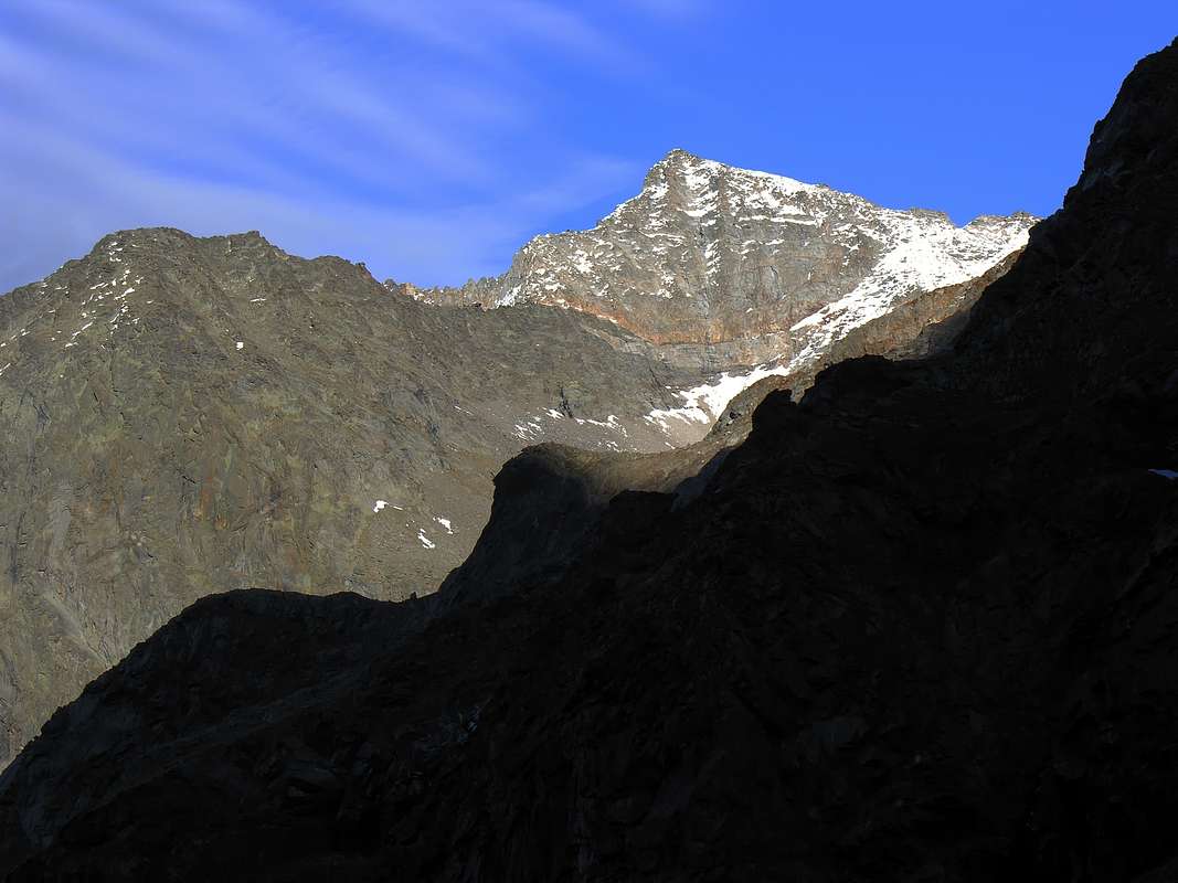
This mountain, confused until the Thirties with Punta di Forzo, the latter, unduly, was called, being higher, Grande Arolla, turning, unexpectedly and improperly, the real one into the nearby Piccola or Little Arolla. A qui pro quo generated by the fact that the first ascenders of August 20, 1879 made a confused and erroneous report that the latter, namely George Yeld and American William Auguste Brevoort Coolidge, in "The Mountains of Cogne (Climbers Guides)"; Edit. London 1893, they immediately contested. It seems paradoxical, because the proto-guide Eliseo Jeantet was from Cogne and therefore had to know her territory well; the real problem lies in the fact, as the Guide of the "Gran Paradiso National Park" points out; page 507; Ediz. Milan September 1980, about the Punta di Forzo. The explanation consists in the fact that the Piccola Arolla and the Punta di Forzo can be glimpsed from Cogne and its surroundings (Champlong Hamlet), while the Grande is completely hidden. But as early as 1896 B&V in the "Guide to the Western Alps VOL. II Graie and Pennine"; pp. 71/2; Ediz. Turin corrected the error by indicating with precision, even if with a little "stoned" or high altitude (as was logical, given the equipment in place in those times), the denomination of the various mountains and relative hills. As well as admirably appears in the beautiful folding sketch or Plate inserted between the same pages and such as to perfectly illustrate the locations.
Confusa insino agli Anni Trenta con la Punta di Forzo, la quale, indebitamente, veniva chiamata, essendo più elevata, Grande Arolla, tramutandola, inopinatamente ed impropriamente, nella vicina Piccola Arolla. Un qui pro quo generato dal fatto che i primi salitori del 20 Agosto1879 effettuarono una relazione confusa ed errata che i secondi, ovvero George Yeld e William Auguste Brevoort Coolidge, in "The Mountains of Cogne (Climbers Guides)"; Edit. London 1893, contestarono immediatamente. Sembra paradossale, perché la protoguida Eliseo Jeantet era di Cogne e quindi doveva conoscere bene il suo territorio; il problema vero consiste nel fatto, come fa osservare la Guida del "Gran Paradiso Parco Nazionale"; pag 507; Ediz. Milano settembre 1980, a proposito della Punta di Forzo. La spiegazione consiste nel fatto che da Cogne e dintorni (Villaggio di Champlong) s'intravvedono la Piccola Arolla e la Punta di Forzo, rimanendo completamente nascosta la Grande. Ma già dal 1896 B&V in la "Guida delle Alpi Occidentali VOL. II Graie e Pennine"; pagg. 71/2; Ediz. Torino correggevano l'errore indicando con precisione, anche se con quote di altitudine un pò "sballate" (come era logico fosse, vista la strumentazione in essere a quel tempo), la denominazione delle varie montagne e relativi colli. Come pure mirabilmente appare nel bellissimo schizzo pieghevole o Tavola I inserito tra le medesime pagine e tale da illustrare perettamente le varie collocazioni dei monti.
Coming to the morphology as well as the structure of the mountain, it should be noted that the same is formed by our ridges that contain and delimit as many slopes:
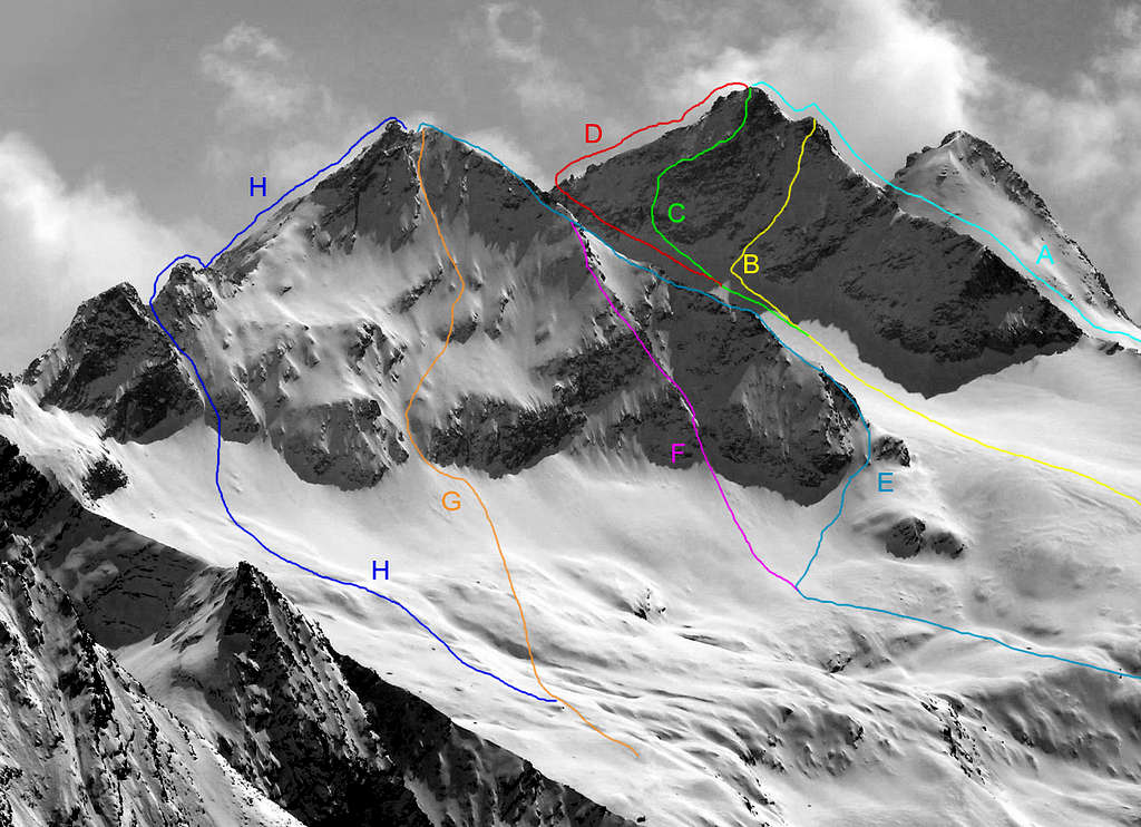
1) - the N-NW Crest rises from the Piccola (Little) Arolla or, better, from the depression 3.226m placed between the two. The first ascents of the same are unknown who, "supplanting" the S-SW Crest, became the usual itinerary in the jagged climb to the pyramid with a not difficult traverse, on very good rock with some exposed passages (from II° to II°+).
2) - The Eastern Crest that rises from Colle di Bardoney (2.823/33m), but you can avoid the same with a "cut" directly from the Lavinetta Glacier at the above 2.902/26m altitudes) in the direction of Colle delle Murailles Rouges (Red Walls Pass; 3.183/7m) is easy to walk (F+) on fairly good rock.
3) - From the Colle delle Murailles Rouges, reachable both from the Eastern side, that is from the Bardoney Valley, surrounding to the Southwest the Lavinetta Glacier, and from the opposite or Valeille with a crossing of the two Northern and Southern Arolla Glaciers from North to South, the short but fun climb S-SW ridge, formed by solid pink granite and rich in grips (II°/II°+). The same can be considered a "second" Normal Route and, in general, is combined with the ascent of the adjacent Punta di Forzo (3.296), which, being higher than 50 meters , was once regarded as the Great Arolla.
4) - The Western Ridge descends to the junction between the two Arolla Glaciers, where a large downhill saddle separates it from the NE side of Innominata Quota (2.838m) and Pointe Cissettaz or Tsissettaz de l'Arolla (2.520m). The latter dividing the Arolla Vallon (to the North) from that of the Sengie (flanking to the Southeast). The same rises in a linear way, passing on the edge of the ridge at the beginning a rocky triangle facing N-NW, a little saddle followed by a small rocky rise to then reachs the Altitude or Quota 3.234m . This last, having formed a small Summit, briefly descends to a kind of small terrace that acts as an ante-Summit, where there are some challenging passages (from II°+ to III°-) but short, that lead to the same, Beyond, in a short time, you reach the Summit. As far as the slopes
5) - are concerned, the large and triangular N-NW Wall drops down to the Southern Arolla Glacier and can be divided, arbitrarily since in reality the same is a whole, into two distinct sectors:
a) - with a "reduced" part of a dozen metersit rises, forming two parallel and small rocky ribs about halfway, towards Altitude 3.234m of just mentioned Western Ridge. Instead
b) - the complete wall on the left sector (East) reaches the Summit with a difference in height of about 260/70 meters. The difference is that while the first can be climbed almost completely in snow (from 35° even to 45°), the second requires you to tackle rocky bands in the medium-high parts (from II°+ to III°-) . While the short (about 100 meters)West Face
6)- descend near (to the West by) the S-SW Crest.
7)- E-NE Wall is more dangerous for the quality of the rock (with stacked and unstable blocks) than difficult (from I°+/II°- to II°+).
8)- S-SE Wall, on the other hand, is made up of splendid rock that is climbed in its center Also for the latter, as for the routes of 1883 (East Ridge and West Side), of 1881 (E-NE Side) of the three of 1983 (Integral of the Western Ridge, via the N-NW Face of Quota 3.234 meters and direct route on the left or eastern side of the same) there is no news of other ascents. This does not exclude that they have been realized, even if, at least until 1980, they do not appear. Therefore, in conclusion, it should be pointed out that the two routes that know a certain frequentation are the S-SW Crest from Colle delle Murailles Rouges and the N-NE one crossing from Piccola or Little Arolla; both are safe, fun and made of good rock, especially the first which, however, requires attention in crossing the two Northern and Southern Arolla Glaciers.
Venendo alla morfologia nonché alla struttura della montagna vi é da osservare che la medesima é formata da quattro creste che contengono e delimitano altrettanti versanti:
1) - la Cresta N-NO sale dalla Piccola Arolla o, meglio, dalla depressione 3.226 m posta tra le due. Sono ignoti i primi salitori della medesima che, "soppiantando" la Cresta S-SO, é diventata itinerario abituale nella frastagliata salita alla piramide con traversata non difficile, su roccia molto buona con qualche passaggio esposto (da II°- a II°+).
2) - La Cresta Orientale che sale dal Colle di Bardoney (2.823/33; ma si può evitare il medesimo "tagliando" direttamente dal Ghiaccio di Lavinetta alle soprastanti quote 2.902/26 m) in direzione del Colle delle Muraillres Rouges (3.183/7) risulta di facile percorso (F+) su roccia discretamente buona.
3) - Dal Colle delle Murailles Rouges, raggiungibile sia dal Versante Orientale cioé dal Vallone di Bardoney, contornando a Sudest il Ghiacciaio di Lavinetta, che dall'opposto o di Valeille con traversata dei due Ghiacciai Settentrionale e Meridionale di Arolla da Nord verso Sud, sale la breve ma divertente Cresta S-SO, formata da solido granito rosato e ricco di appigli (II°/II°+). La medesima può essere considerata una "seconda" Via Normale ed, in genere, viene abbinata alla salita dell'adiacente Punta di Forzo (3.296), la quale, essendo appunto più elevata di 50 metri, una volta era considerata come la Grande Arolla.
4) - La Cresta Occidentale scende fino alla congiunzione tra i due Ghiacciai di Arolla, dove una larga sella in discesa la separa dal Versante NE dell'Innominata Quota (2.838 m) e della Pointe Cissettaz o Tsissettaz de l'Arolla (2.520 m); queste ultime divisorie il Vallone di Arolla (a Nord) da quello delle Sengie (a Sudest). La stessa sale in modo lineare superando sul filo di cresta all'inizio un triangolo roccioso rivolto a N-NO, una selletta seguita da un piccolo rialzo roccioso per poi raggiungere la Quota 3.234m. Quest'ultima, formata una piccola cima, discende brevemente ad una specie di terrazzo che funge da ante cima, dove esistono alcuni passaggi impegnativi (dal II°+ al III°-) ma brevi, che conducono al medesimo. Oltre, in breve, si raggiunge la Cima. Per quanto concerne i versanti
5) - la larga e triangolare Parete N-NO s'abbassa sul Ghiacciaio Sud d'Arolla e può essere divisa, arbitrariamente poiché in realtà la medesima é un tutt'uno, in due distinti settori:
a) - con una parte "ridotta" d'una dozzina di metri sale, formando a metà strada due costoline rocciose parallele, verso la Quota 3.234m sull'appena citata Cresta Occidentale; invece
b) - la parete intera sul settore di sinistra (Est) raggiunge la Sommità con un dislivello di circa 260/80 metri. La differenza consiste che mentre la prima può essere scalata quasi completamente in neve (da 35° ad anche 45°), la seconda richiede di affrontare delle fasce rocciose nelle parti medio-alte (dal II°+ al III°-). Mentre la corta (100 metri circa) Parete Ovest
6) - scende affiancando la Cresta S-SO.
7) - Il Versante E-NE é più pericoloso per la qualità della roccia (blocchi accatastati ed instabili) che difficile (dal I°+/II°- al II°+).
8) - La Parete S-SE invece é formata da splendida roccia e viene percorsa nel centro. Anche per quest'ultima, come per le vie del del 1883 (Cresta Est e Versante Ovest), del 1881 (Versante E-NE) delle tre del 1983 (Integrale della Cresta Occidentale, via alla Parete N-NO della Quota 3.234 metri e via diretta sul lato sinistro od Orientale della medesima) non si hanno notizie di altre ascensioni. Ciò non esclude che siano state realizzate, anche se, almeno fino al 1980, non risultano, come da Guida del "Gran Paradiso Parco Nazionale"; Ediz. Milano settembre 1980. Quindi, in conclusione, c'é da evidenziare il fatto che le due vie che conoscono una certa frequentazione sono la Cresta S-SO dal Colle delle Murailles Rouges e quella N-NE in traversata da Nord verso Sud o dalla Piccola Arolla; entrambe sono sicure, divertenti e formate da buona roccia, particolarmente la prima che richiede però attenzione nell'attraversamento dei Ghiacciai Settentrionale e Meridionale di Arolla.
First ascents
Grande Arolla:
First on the summit (E-NE Slope): L. Vaccarone, M. Andreis and A. Tavallini, (Aug 02th, 1881).
In winter: Giuliano Calosci and A. Piatto, (winter 1924?); in ascent on N-NW Ridge from Piccola Arolla.
N-NW Arête (Normal Route): Unknown. In ascent with crossing from Piccola Arolla.
E-NE Slope: L. Vaccarone, M. Andreis and A. Tavallini, (Aug 02th, 1881); in ascent from Cogne, Lillaz Hamlet, Bardoney Alp, Vallon and Pass.
E Arête: G. Yeld, S. Henry and G. Jeantet, (Aug 11th, 1883); in ascent from Bardoney Vallon and Col.
S-SE Wall: F. Ravelli, (Jul 07th, 1919); in ascent from Grange or Cugni Pastures into the Forzo Valley in Canavese Area.
S-SW Arête: C. De Fernex, U. Malvano and Mountain Guide Casimiro Thérisod (Jul 23th, 1901); in ascent from Col des Murailles Rouges.
W Wall: G. Yeld, S. Henry and G. Jeantet, (Aug 11th, 1883), in descent from the Top, after the ascent through Eastern Ridge from Bardoney Vallon.
W Ridge (integral from Arolla South Glacier): Osvaldo and Christian Cardellina and Marco Cossard, (Jul 31th, 1983), in ascent from the junction North/South of Arolla Glaciers; in descent South Crest to Col des Muralles Rouges, crossing on Punta di Forzo, descent to Bardoney Col, Lavinetta Glacier, Vallon de Bardoney.
N-NW Wall (Direct Via on Triangular Face of Quota 3.234 meters) and W Ridge in final part: Osvaldo and Christian Cardellina and Marco Cossard, (Aug 16th, 1983), in ascent from Lillaz, Valeille, Arolla Alps, Arolla North Glacier; in descent S-SO Crest to Col des Muralles Rouges, West Slope to South Arolla Glacier.
N-NW Wall (Direct Route on Eastern Side to Top): Osvaldo, solo, (Aug 24th, 1983), in ascent from Lillaz, Valeille and Arolla Alps, Arolla North Glacier; in descent S-SO Crest to Col des Muralles Rouges and traverse to Punta di Forzo 3.296m, round trip, with subsequent descent on West Slope towards South Arolla Glacier.
Getting There
BY CAR:
From Torino, Milano, etc: Motorway A5. Exit at Aosta Ovest. Drive to the near Aymavilles. Follow the directions for Valle di Cogne.
From Switzerland: through the Grand Saint Bernard Tunnel or the namesake Pass. Drive to Aosta, then follow the direction for Courmayeur on SS.26. Just after Sarre, turn to the left, in the direction of Valle di Cogne.
From France: through Mont Blanc Tunnel or Petit St. Bernard Pass. It isn't necessary to take Motorway A5: you can drive on SS.26, in the direction of Aosta. Before arriving at the Village of Sarre, turn right following the sign for Valle di Cogne. After Aymavilles, the SR.47 crosses the Villages of Vieyes, Epinel and Cretaz and after about 25 Km arrives at Cogne (1.534m). From Cogne you can get the Village of Lillaz (1.617m).
BY PLANE:
Aeroporto "Corrado Gex" Saint Christophe (Aosta).
Route
Starting from Cogne (1.534m) you must arrive (bus or car) to the car parking of Lillaz (1.617m). Start ascending along the path pointing to Valeille Valley, after a terrace follow up to a bridge near a big boulder. Cross the bridge and follow the mule track till the fork leading to the Arolla Hut of Gran Paradiso National Park, on along some steep hairping to reach the terrace hosting the hut (2.259m). Now follow for the Arolla Glacier passing to the right a crevassed bump, then keep the center of the glacier, limited by the Arolla Summits and the Punta di Forzo, to get the Colle di Muraille Rouge (3.183m) paying attention to the bergschrund. Climb the big stones of the ridge (I°+) and, once on the summit of the Grande Arolla (3.296m) start the short and jagged ridge (some exposure and some not easy passages on rock : III°-) leading to the summit of the Piccola Arolla (3.232m) (6h'00/6h'30 hours from Lillaz).
Descent: Coming down along the same route.
Dall'abitato di Cogne (1.534 m), in bus o in auto, raggiungere la ridente Frazione di Lillaz (1.617 m), dove si parcheggia nel grande piazzale sito quasi al centro del villaggio. Iniziare la salita imboccando il sentiero che si dirige nel Vallone di Valeille; dopo aver superato un gradone, si prosegue sino a un ponte sito a breve distanza di un grande macigno. Dopo averlo attraversato, continuare lungo la mulattiera sino al bivio che conduce al Casotto "Arolla" del Parco Nazionale del Gran Paradiso; risalire il sentiero per ripidi tornanti sino a raggiungere la capanna posta su uno spalto (2.259 m). Proseguire sino al Ghiacciaio dell'Arolla superando sulla destra una "gobba" crepacciata. Continuare la salita tenendosi al centro del ghiacciaio racchiuso fra le due Arolle e la Punta di Forzo; raggiungere il Colle di Muraille Rouge (3.183 m) facendo attenzione alla crepaccia terminale. Risalire la cresta su grandi blocchi (I°+) e, toccata la vetta della Grande Arolla (3.296 m), iniziare la traversata della breve e frastagliata cresta (con passaggi esposti e abbastanza impegnativi; III°-) che conduce alla vetta della Piccola Arolla (3.232 m) (ore 6h'00/6h'30 da Lillaz).
Discesa: Per la stessa via di salita.
Difficulties
This route can be considered AD-.
Gear
Classic for high mountain routes: rope, helmet, iceaxe, crampons.
Classica per le vie d'alta montagna con corda, elmetto, piccozza e ramponi.
Red Tape
Within the borders of the P.N.G.P. (Parco Nazionale del Gran Paradiso), at the moment (summer 2004), dogs generally are not allowed, except on a couple of trails, and camping is forbidden (except for climbers from sunset till dawn). No fees are due.
"Guida delle Alpi Occidentali" di Giovanni Bobba e Luigi Vaccarone C.A.I. Sezione di Torino Volume II (parte II), 25 Maggio 1896.
"Gran Paradiso" di Pierandrea Mantovani e Renato Misischi, Ed. Rassegna Alpina, 1974.
"Diari Alpinistici" di Osvaldo Cardellina e Indice Generale accompagnato da Schedario Relazioni Ascensioni 1964-2021 (inediti).
"Gran Paradiso" A. Gegenfurtner, G. Klotz, F. Müller, Ed. Bergverlag Rudolf Rother, Monaco 1980 (in tedesco).
"Gran Paradiso" G. Klotz Ed. Bergverlag GmbH Rother, Monaco 2005 (in tedesco).
"Gran Paradiso - Itinerari Alpinistici e sci Alpinistici" di Franco Brevini Ed. Musumeci, Giugno 1982.
"Il Parco Nazionale del Gran Paradiso (Valli di Champorcher-Clavalitè-Saint Marcel-Laures-Cogne-Valsavarenche-Conca di Pila" di Giulio Berruto 3/volume 2°, IGC, Torino 1981, 2a Ed. 2000. (in Italian)
"Guida dei Monti d'Italia-Gran Paradiso Parco Nazionale" E. Andreis, R. Chabod, M. C. Santis, Club Alpino Italiano/Touring Club Italiano, prima Ed. 1939; seconda Ed. 1963; terza Ed. 1980.
MAPS:
Kompass "Gran Paradiso Valle d'Aosta Sentieri e rifugi" Carta turistica 1:50.000.
I.G.C. Istituto Geografico Centrale "Gran Paradiso-La Grivola-Cogne" Carta turistica 1:25.000.
A.IA.T "Cogne Gran Paradiso Cogne Aymavilles-Walking map" 1:25.000.
L'Escursionista "Valle di Cogne Carta dei Sentieri" (n° 10) 1:25.000.
L'Escursionista "Tour de la Vallée de Cogne Grand Paradis" Carta dei sentieri 1:25.000.
Parents refers to a larger category under which an object falls. For example, theAconcagua mountain page has the 'Aconcagua Group' and the 'Seven Summits' asparents and is a parent itself to many routes, photos, and Trip Reports.

 10671 Hits
 93.1% Score
 41 Votes