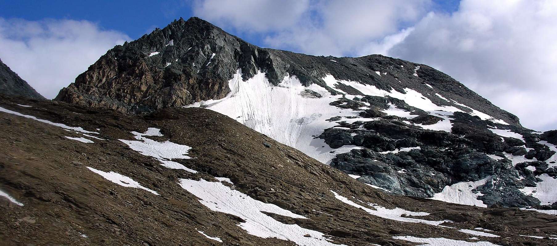
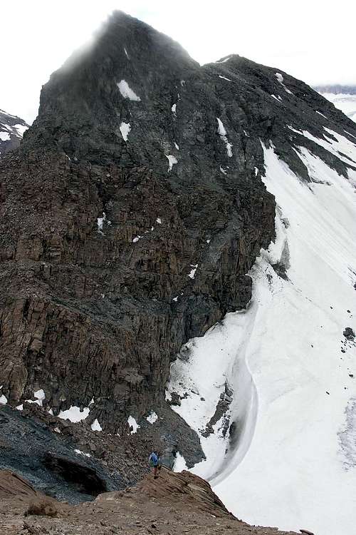
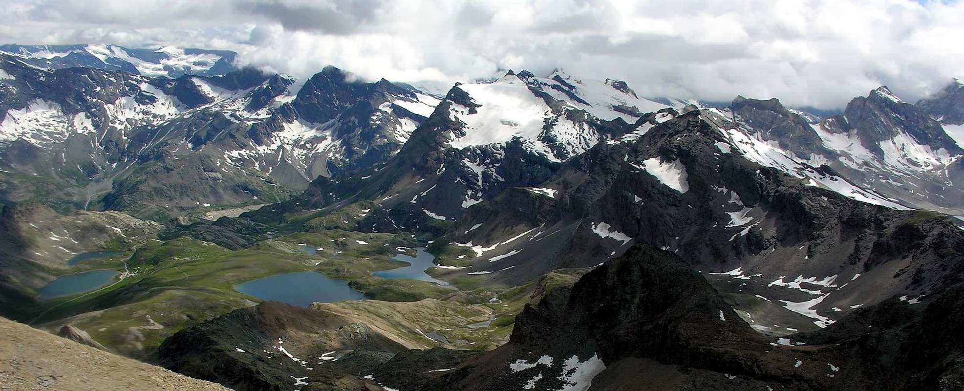
Little pyramid placed on very long (more than 23 Km~) ridge from outermost and extreme topographic knot-crux of the Punta Galisia (3.346m; amongst French/Piedmont/Aosta Valley) to Monte Paillasse (2.414m; upon the Dora Stream in Central Valley) and into the watershed of the Rhêmes/Valsavarenche Valleys. In ancient times even named Punta Vaudaletta or Vaudalettaz (See the "Guide of the Western Alps - Graian and Pennine Alps", Volume II°, Second Part, by Giovanni Bobba and Luigi Vaccarone; Edit in Turin on 1896). Mountain consisting of two small pyramids located immediately NE of the Punta del Rosset (3.100m) and the homonymous Hill (3.023/25m); the first or Southern (3.224/25m) is smaller in size, although it has a fairly long crest towards the NW which reaches Col Cornet (2.670/9m) and the underlying Mont Cornet (2.562/70m), apt to separate the Vallone della Vaudala to the South from that of Vaudaletta (North). It turns out to be a purely hiking summit or suitable for ski mountaineering, especially on the NW flank where it descends not excessively steep (32°/28°) towards the West on the remains of Glacier de Vaudalettaz.The second, or Punta NE, has a more mountaineering aspect, thanks to the Northern side above Colle Leynir (3.084m). To be precise, starting from the Southeast and towards the Northwest, we find an East Ridge, which links this pyramid to Punta Celestino Bes (3.177), a short (just over a hundred meters) but steep E-NE Wall above the Vallone del Lago Nero, a NE Crest, quite steep but easy above Colle Leynir, the dreary NW Face (about 160 meters), limited to the West by an edge very small (about 65/70 meters), both dominating the Vaudaletta Glacier (both the two walls that the edge appears to have been climbed in a single occasion and no longer repeated). Unfortunately, the quality of the rock, also, with great contrast to the eye, through reddish-yellowish tuff intrusions inside a bluish-greenish serpentinite, does not allow great possibilities for safe climbing, while, on the contrary, it requires continuous and vigilant attention to the fall of stones suspended on the numerous ledges. But generally the summit is also visited for hiking or ski-mountaineering purposes, generally starting from the NW from the Grand Vaudala Vallon in the Rhêmes Valley or from that of the lakes above Nivolé or Nivolet Pianoro (Tableland). With approach from Savoia Refuge (2.610m) or the Shelter City of Chivasso (2.600m) at the Nivolé's Hill (2.612/36m) and in any case always via the Col Rosset (3.023/25m) with an excursion reserved for BSA (Good Skiers Alpinists ). Popular excursion by start from Rosset Pass whether through Rhêmes Slope or from Nivolé Tableland in Valsavarenche (from Savoia and Chivasso Town Refuges); not so much from Leynir Pass, Rhêmes Slope, and less and less from Black Loch Basin, always in Valsavarenche, for a more engaged and complex route. Good views to Gran Paradiso Mountain Chain in Northeast and to Upper Head of Rhêmes Valley (Roc Basagne, Roc du Fond, Punta Calabre, Punta Tsanteleina, Granta Parei and Gran Traversière) and to Great Sassière Group in West-southwest, hardly more in distance.
Piccola piramide situata sulla lunghissima cresta (oltre 23 Km~), che dall'estremo nodo della Punta Galisia (tra Francia, Piemonte e Valle d'Aosta) scende sino al minuscolo Mont Paillasse affacciandosi sulla Valle Centrale della Dora Baltea e percorrente tutto il crinale spartiacque tra le Valli di Rhêmes/Savarenche. Nei tempi passati anche nominata Punta della Vaudaletta (Vedi nella "Guida delle Alpi Occidentali - Alpi Graie e Pennine", Volume II°, Parte Seconda, autori Giovanni Bobba e Luigi Vaccarone ed editata in Torino nell'anno 1996). Montagna costituita da due piccole piramidi poste subito a NE della Punta del Rosset (3.100 m) e dell'omonimo Colle (3.023/25 m); la prima o Meridionale (3.224/25 m) é di dimensioni più ridotte, anche se presenta un'abbastanza lunga cresta verso NO che raggiunge il Col Cornet (2.670/91 m) ed il sottostante Mont Cornet (2.562/70 m), atta a separare il Vallone della Vaudala a Sud da quello di Vaudaletta a Nord. Risulta essere sommità prettamente escursionistica oppure atta allo sci-alpinismo, sorattutto sul Versante NO dove scende non eccessivamente ripida (32°/28°) verso i resti del Glacier de Vaudalettaz. La seconda, o Punta NE, possiede un aspetto maggiormente alpinistico, grazie all'intero Versante Settentrionale al di sopra del Colle Leynir (3.084 m). Per la precisione, partendo da Sudest e verso Nordovest, troviamo una Cresta Est, che lega questa piramide alla Punta Celestino Bes (3.177 m), una breve (poco più di un centinaio di metri) ma ripida Parete E-NE al di sopra del Vallone del Lago Nero, una Cresta NE, abbastanza ripida ma facile sopra il Colle Leynir, la tetra parete NO (circa 160 metri), limitata ad Occidente da uno spigoletto Ovest (circa 65/70metri), entrambi dominanti il Glacier di Vaudaletta (sia le due pareti che lo spigolo risultano essere stati saliti in un'unica ccasione). Purtroppo la qualità della roccia, anche, con grande contrasto alla vista, tramite intrusioni tufiche rossiccio-giallastre all'interno di una serpentinite bluastra-verdastra, non concede grandi possibilità di arrampicata sicura, mentre, al contrario, richiede una continua e vigile attenzione per la caduta di pietre sospese sulle numerose cenge. Ma in genere la sommità viene visitata anch'essa a scopo escursionistico oppure sci-alpinistico, in genere partendo da NO dal Vallone della Grand Vaudala in Valle di Rhêmes oppure da quello dei laghi sopra il Pianoro del Nivolé o Nivolet. Con approccio dai Rifugi Savoia (2.610 m) oppure Città di Chivasso (2.600 m) presso il Colle del Nivolé (2.612/36 m) e comunque sempre tramite il Col Rosset (3.023/25 m) con gita riservata a BSA (Buoni Sciatori Alpinisti). Gita abbastanza frequentata con partenza dal Colle Rosset sia sul versante Rhêmes che dal Pian del Nivolé in Valsavarenche (Rifugi Savoia e Città di Chivasso); molto meno dal Colle del Leynir versante Rhêmes ed ancor meno dalla Comba del Lago Nero, sempre dalla Valsavarenche, per il percorso più complicato nella scelta della via e, sicuramente, più impegnativo. Belle viste verso NE sulla Catena del Gran Paradiso ed in W-SW sull'intera alta testata della Valle di Rhêmes (Roc Basagne, Roc du Fond, Punta Calabre, Tsanteleina, Granta Parei e Grande Traversière), nonché sul Gruppo della Grande Sassière, appena più lontano.
First Ascents
Northeastern Summit (3.235m)
First on the summit: Unknown.
In winter: Unknown.
E Slope and S Crest: Nino Daga Demaria, (Aug 02th, 1957).
SW Slope: Nino Daga Demaria, (Jun 23th, 1959).
W Edge: Osvaldo Cardellina, Marco Cossard and Camillo Roberto Ferronato (Jul 15th, 1978); in ascent from Thumel, Vaudaletta Alp and just below the Leynir Col; in descent, after crossing to Southern Summit (3.224m), by Northern Face of the same towards Vaudalettaz's Vallon.
E-NE Wall: Osvaldo Cardellina, Christian Cardellina (9 years-old) and Camillo Roberto Ferronato (Jul 07th, 1982); in ascent from Thumel, Vaudaletta Alp, crossing to the East the Leynir Col; in descent, after crossing to South Summit (3.224m), by W-NW Ridge of the same towards Col Cornet (2.670m), Vaudalettaz's Vallon.
S-SE Ridge: (Integrally): Osvaldo Cardellina, Marco Cossard, Camillo Roberto Ferronato, Giuseppe Lamazzi and Nino Trapani (Jul 28th, 1974), in descent up to the Punta Celestino Bes.(3.177m), after the crossing from Punta Basei(3.338m)
Great Traverse from Basei Point–Quota 3.163m–Cima di Nivoletta S Point–Cima di Nivoletta N Point–Great Vaudala S Point–Great Vaudala N Point–Rosset Point–Leynir S Point–Leynir NE Point–Celestino Bes Point: Osvaldo Cardellina, Marco Cossard, Camillo Roberto Ferronato, Giuseppe Lamazzi, Nino Trapani and N. Sandretto, (C.A.I. Ivrea the last as far as to Rosset Pass), (Jul 28th, 1974).
Southwestern Summit (3.224m)
First on the summit: Unknown.
In winter: Unknown.
SW Crest (Normal Via): Unknown; ascent from Col Rosset (3.023/25m).
W-NW Ridge: Osvaldo Cardellina, Christian Cardellina (9 years-old) and Camillo Roberto Ferronato (Jul 07th, 1982); in descent, after crossing from Northern Top to Southern Summit (3.224m), towards Col Cornet (2.670m), with descent by Northern Slope on Vaudalettaz's Vallon.
Getting There
BY CAR:
From France: through the Mont Blanc Tunnel or the Col du Petit Saint Bernard: you can drive on SS.26, following directions for Aosta and, before arriving in Villeneuve, turn right towards Introd. Alternatively, you can take Motorway A5 (at Courmayeur or Morgex) and exit at Aosta Ovest.
From all the other directions: get to the Aosta Ovest exit of Motorway A5. Then drive on SS.26 Aosta, in the direction of Courmayeur; just after Villeneuve turn left towards Introd.
BY PLANE:
Aeroporto "Corrado Gex" Saint Christophe (Aosta).
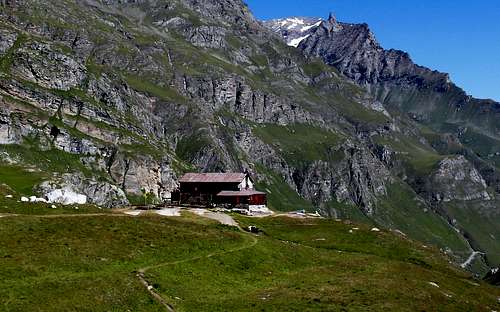
Enter the valley and, at the fork between Valsavarenche and Val di Rhêmes turn to the right (Rhêmes). Cross all the villages to arrive to Rhêmes Notre Dame and follow to Thumel (car parking), herefrom, following the dirt road on the right side (ascending) of the valley, or, better with snow, a track on the left that passing throught some fine woods leads you to the Rifugio Benevolo (2.285m).
Approachs
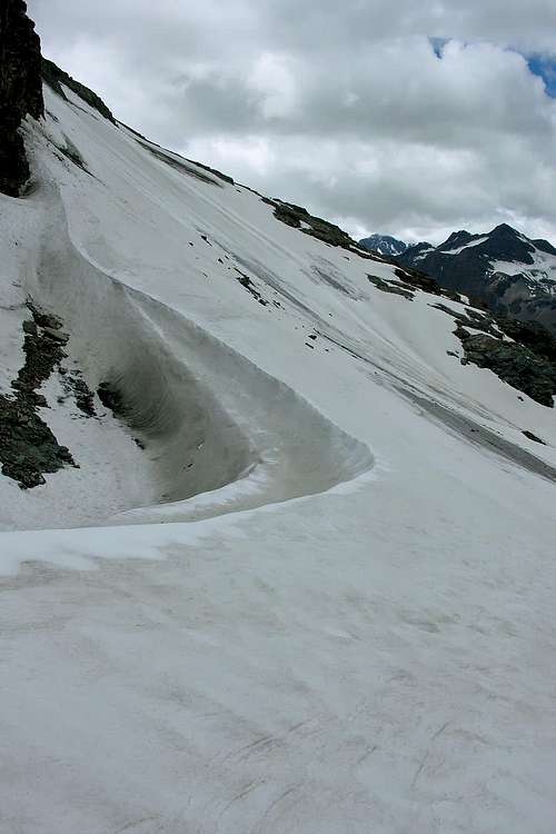
A) - To Leynir Pass through Vaudaletta(z) little Valley: from main road and about 300 meters after the great earth Parking (1.848m) and as many of the beginning of the dirt road to Benevolo Hut, turn left (abounding signs and panneaux; frontally splendid Vaudaletta Waterfall); by a brief descend reach the tiny Thumels's Village (1.879m), nearby the Rhêmes Doire (Stream). Continue on ground road about other 100 meters to forest joining a little bridge upon a mini canyon; go up by a small path n° 11, through the" wood" and along Vaudaletta Torrent with namesake waterfall. overcoming first steep promontory path lop nearby a vast tableland in false level route; immediately afterwards, changing direction from Southeast to Norh-northeast, cross below pasture (2.443m) and rejoin the P.N.G.P. Casotto (Hunting House for the Rangers Guardians of the Great Paradise National Park; (2.480m). Again change direction in East, reaching the fork of two torrents in quota 2.574m; leaving the Vaudaletta Torrent in left (North) continue, same path, through a hemi circular tour in moraine to remains of the Vaudaletta Glacier. By a last diagonal, bordering left (East; small crevices extant) the glacier, reach the Leynir Pass (3.084m; EE; 3h'30/4h'00).
A) - Al Colle del Leynir tramite il Valloncello della Vaudaletta: dalla strada regionale e circa 300 metri dopo il grande Parcheggio in terra battuta (1.848 m) ed altrettanti prima del divieto della strada poderale per il Rifugio Benevolo, girare a sinistra (cartelli ed abbondanti segnalazioni; frontalmente splendida Cascata di Vaudaletta) e, con breve discesa, raggiungere il grazioso Villaggio di Thumel (1.879 m), presso la Dora di Rhêmes. Continuare sulla strada sterrata per un centinaio di metri e verso il bosco raggiungendo un ponticello sovrastante un mini canyon. Prendere a salire per mezzo del piccolo sentiero n° 11, con numerosi e stretti tornanti, attraverso la foresta e fiancheggiando il percorso del Torrente Vaudaletta e relativa cascata. Vincendo il primo ripido risalto il sentiero lambisce il torrente vicino ad un vasto altipiano con percorso in falsopiano; subito dopo, cambiando direzione da SE in N-NE ed attraversando al di sotto dell'Alpe Vaudaletta (2.443 m), raggiunge il Casotto del P.N.G.P. (2.480 m). Variando nuovamente direzione in E raggiungere la biforcazione del torrente a quota 2.754 m; abbandonando a sinistra (N) il ramo principale del torrente, continuare, sempre con il medesimo sentiero, con percorso semicircolare sulla morena verso ciò che resta del Ghiacciaio di Vaudaletta. Con un ultimo diagonale al margine sinistro (E; presenza di piccoli crepacci) del medesimo raggiungere il Colle del Leynir (3.084 m; EE; 3h'30/4h'00).
B) - To Rosset Pass through Vaudala little Valley: from main road to earth great Parking 1848m, nearby the Rhêmes Stream; continue through ground road about other 100 meters as far as the no thoroughfare sign of the dirt road to Benevolo Refuge. On contrary, by South direction, go up with path n° 13 to hut (abounding panneaux and signs in start near a Pasture 1.901m) along the torrent still under the Saint Pantaleon Chapel (2.010m); just before to abandon and moving left (South) go up by the path n° 12. Crossing in succession same level route the Rhême's Stream and the Vaudala Torrent, go up through the forest by more and more narrow hairpin bends and along the Vaudala Torrent; through a long linear diagonal reach the Great Vaudala Pasture (2.338m). From this, and always near the same, wade across a secondary ramification and continue along the principal, South direction and to moraine in quota about 2.600 meters. Chancing the path direction in East-Southeast, reach a little source before the terminal part; on the same with fatiguing route and by a rotten rocky, debris and steep path go up the last stretch to Rosset Pass (3.023m; EE; 4h'00/4h'30).
B) - Al Colle Rosset tramite il Valloncello di Vaudala: dalla strada regionale raggiungere il gran Parcheggio 1.848 m, in terra battuta e vicino alla Dora di Rhêmes; continuare per un centinaio di metri sino al cartello di divieto di transito con veicoli per la poderale adducente al Rifugio Benevolo. Prendere invece, volgendo a S, il sentiero n° 13 per lo stesso (ricca segnaletica alla partenza presso l'Alpeggio 1.901 m) e proseguire parallelamente al torrente e fin sotto la Cappella di Saint Pantaleon (2.010 m); appena prima della stessa abbandonarlo e spostandosi a sinistra (S) utilizzare il sentiero n° 12. Guadando a circa 2.000 metri, in successione prima la Dora e poi il Torrente Vaudala, risalire verso il bosco con tornanti sempre più stretti fiancheggianti il Torrente Vaudala; con un lungo e lineare diagonale raggiungere l'Alpe di Gran Vaudala (2.338 m). Da questa, e sempre presso il torrente stesso, guadarne una ramificazione secondaria continuando invece dappresso alla principale, direzione S e verso la morena a quota 2.600 metri circa. Cambiando in E-SE la direzione del sentiero, raggiungere una minuscola sorgente prima di affrontare la parte terminale; sulla stessa, con percorso faticoso ed a mezzo di un sentiero di rocce in frantumi e detriti e con un ultimo tratto ancor più ripido, raggiungere il Colle Rosset (3.023 m; EE; 4h'00/4h'30).
C) - From Gian Federico Benevolo Refuge From hut (2.285m) before return to dirt road through a brief descent Southeast direction, after to follow the same about 220 meters NE direction as far as the first hairpin bend (panneau with signs); begin the small path n° 13A; with this and through a long diagonal in North-northeast, moderate slope, reach the quota 2.316m. Turning progressive Northeast, East-northeast and crossing between the quotas 2.407m e 2.417m, double at base the terminal quota 2.526m of the N-NW Crest Lavassey Point (2.772m), in entrance right (South) of Great Vaudala little Valley. Reversing the route with Southeast direction, by an other brief diagonal reach and wade across the namesake torrent and join the path n° 12 of Approach B, just below the Great Vaudala Pasture (2.338m) (E; 0h'45/1h'00 for the connection).
C) - Dal Rifugio Gian Federico Benevolo (2.285 m) ritornare prima verso SE con breve discesa alla strada poderale, poi seguirla a NE per circa 220 metri verso il primo tornante della stessa (cartello indicatore); prendere il piccolo sentiero n° 13A che, con un lungo e di pendenza moderata diagonale in direzione N-NE, porta alla quota 2.316 m. Svoltando progressivamente in NE e poi in E-NE, e passando tra le quote 2.407 m e 2.417 m, doppiare alla base la quota terminale 2.526 m della Cresta N-NW della Punta di Lavassey (2.772 m), all'entrata destra (S) del Vallone della Gran Vaudala. Invertendo direzione in SE, con un altro breve diagonale, raggiungere e guadare l'omonimo torrente e ricongiungersi al sentiero n° 12 dell'Avvicinamento B, proprio sotto l'Alpe Gran Vaudala (2.338 m) (E; 0h'45/1h'00 per il collegamento).
Routes
N-NE Edge: from Leynir Pass (3.084m)climb on edge of the brief, but enough steep, NE Ridge by a non difficult and broken rocks, eventually leaning or turning left (East); in terminal part overcome a passage more hard (II°+) and more and more, through same side over mentioned, exposed. After briefly and easily in final part to NE Summit (EE/A; difference in level about 150m~; 0h'30/0h'45).
Spigolo N-NE: dal Colle Leynir (3.084 m)risalire sul breve, ma abbastanza ripido, Spigolo N-NE tramite rocce non difficili e piuttosto rotte, eventualmente appoggiandosi a sinistra salendo o doppiando sempre ad E alcuni passi; nella parte terminale vincere un passaggio più esposto, attraverso lo stesso lato sopra citato, che impegnativo (II°+). Infine raggiungere la Vetta con un tratto finale breve e non difficile (EE/A; dislivello 150 m~; 0h'30/0h'45).
S-SW Crest: from Rosset Pass (3.023m)climb before by a easy, moderate slope, to a great trigonometric signal up the Quota 3.147m; continue always in Northeast direction overcoming an amusing and west inclined slab. Subsequently and still without difficult reach the Leynir SW Summit (3.224m; great stoneman) and by better and better route to NE Summit (EE; difference in level 210/220m~; 0h'45/1h'00).
Cresta S-SW: dal Col Rosset (3.023 m)risalire la cresta dapprima con moderata pendenza ed in assoluta facilità sino al primo grande segnale trigonometrico posizionato sulla Quota 3.147 m; continuando sempre con direzione NE vincere una divertente placca inclinata ad O. Successivamente raggiungere, sempre agevolmente, la Sommità SW (3.224 m.; grosso ometto in pietra) e tramite sempre miglior percorso quella NE (EE; differenza in dislivello 210/220 m~; 0h'45/1h'00).
The Eastern side of the valley belongs to Gran Paradiso National Park, the Western one is out of the boundaries of the Park ... but nature must be respected.
Campings
Remember that free camping is forbidden (except for emergency reasons, over 2.500m, from darkness until dawn).
Mountain Conditions
You can get meteo information at the official site of the Regione Valle d'Aosta:
"Guida dei Monti d'Italia-Gran Paradiso Parco Nazionale" E. Andreis, R. Chabod, M. C. Santis, Club Alpino Italiano/Touring Club Italiano, prima Ed. 1939; seconda Ed. 1963; terza Ed. 1980.
"I Rifugi della Valle d'Aosta" di Stefano Ardito, Ed. Guide iter, Febbraio 2003.
"Diari Alpinistici" di Osvaldo Cardellina e Indice Generale accompagnato da Schedario Relazioni Ascensioni 1964-2019 (inediti).
MAPS:
Kompass "Gran Paradiso Valle d'Aosta Sentieri e Rifugi" Carta Turistica 1:50.000.
Enrico Editore Ivrea-Aosta "Gruppo del Gran Paradiso" 1:50.000.
I.G.C. Istituto Geografico Centrale Torino "Valsavarenche Val di Rhemes Valgrisenche Parco Nazionale del Gran Paradiso", (carta n° 102), 1:25.000.
I.G.C. Istituto Geografico Centrale Carta dei sentieri e dei rifugi "Il Parco Nazionale del Gran Paradiso" 1:5.0000.
Parents refers to a larger category under which an object falls. For example, theAconcagua mountain page has the 'Aconcagua Group' and the 'Seven Summits' asparents and is a parent itself to many routes, photos, and Trip Reports.

 7291 Hits
 86.37% Score
 22 Votes