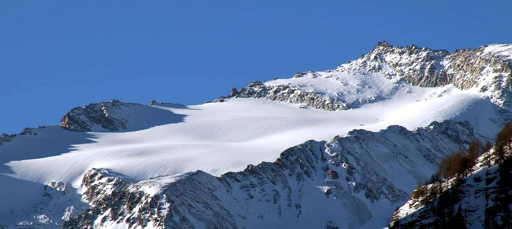
One of the most popular summits on the lower or Northern long spur of Gran Paradiso Group that reaches the pyramid of Grivola (3.969m), the Gran Serra grows up, well distinguished, from the ridge between the Herbetet and the same last: so its little subgroup is the transition zone between two very different kind of rocks (gneiss of Gran Paradiso and green rocks and limestones of Grivola). It is a not small mountain, it is a big ridge between the Valsavarenche and the Valnontey (this last into the Southern Cogne Valley), most covered by (easy) glaciers. The highest part has a "little castle" rocky formed from large blocks, that give the impression of a singular turret suspended in space above the wide and almost endless glaciers. No difficult routes on this summit that can be climbed in any season, the only problem can be given by the rocks on the higher part when iced, but the transition is quite short and requires only a small bypass to the South by large overlapping blocks with fun climbing. Surely it is one of the most popular touring trips of Ski-Mountaineering into the Area Gran Paradiso, that bestow great views over the entire mountain chain.
Una delle vette più popolari nella parte inferiore del lungo Contrafforte Settentrionale che raggiunge la Grivola (3.969 m) nel Gruppo del Gran Paradiso, la Gran Serra si eleva, ben distinto, dal crinale tra l'Herbetet e quest'ultima: il suo piccolo sottogruppo è zona di transizione tra due molto diverse tipologie di rocce (gneiss del Gran Paradiso e rocce verdi e calcari della Grivola). Non trattasi d'una piccola montagna, bensì risulta quale grande cresta tra la Valsavarenche e la Valnontey (quest'ulmima a Meridione all'interno della Valle di Cogne); la maggior parte della medesima viene ricoperta da ghiacciai, con difficili da percorrere. La parte più elevata presenta un "castelletto" roccioso formato da grandi blocchi, che danno l'impressione di una singolare torretta sospesa nel vuoto sopra gli estesi e, visti da qui, quasi infiniti ghiacciai. Nessuna delle vie della montagna risulta particolarmente difficile; la stessa può essere salita in ogni stagione. L'unico problema può essere dato dalle rocce sulla parte superiore allorché si trovino ghiacciate, ma il passaggio é alquanto breve e richiede eslusivamente un piccolo aggiramento verso Mezzogiorno, tramite grandi blocchi sovrapposti di divertente scalata. Sicuramente risulta una delle gite di Sci-alpinismo più frequentate nell'Area del Gran Paradiso, tale da elargire splendide vedute sull'intera catena montuosa.
First Ascents
First on the summit (from S-W Arête): G. Yeld, A. Payot and L. Guichardaz, (Aug 09th, 1879).
In winter: E. Denina and P. Sella, (Dec 30th, 1928).
W Slope: G. Origoni and L. Blanc, (Aug 23th, 1890).
N Arête: E. Denina and C. Pol, (Aug 17th, 1928), in descent.
N Arête E Slope: W. B. A. Coolidge, F. Gardiner, C. and R. Almer, (Aug 19th, 1889).
E Arête: G. Bobba and E. Jeantet, (Aug 20th, 1887).
W Slope: Fleurette e Giuliano Calosci, (Jul 10th, 1940).
Getting There
Leave the Highway at "Aosta Ovest" (West), drive through Aymavilles and continue to follow the main street until you arrive in Cogne. HOW TO REACH AOSTA:
From Italy: Milan - Novara - Ivrea - Pont-Saint-Martin - Saint Vincent - Aosta, or: Turin - Ivrea - Aosta.
From Switzerland: Bern - Montreux - Martigny - Colle del Gran San Bernardo - Aosta, or: Sion - Martigny - Col du Grand Saint Bernard - Aosta or: Bellinzona - Lugano - Como - Milano (only direction) - Novara - Aosta.
From France (also Genève): Tunnel del Monte Bianco (toll) - Courmayeur - Aosta or (less expensive but a little longer, if you come from Genève take the tunnel!): Colle del Piccolo San Bernardo - La Thuile - Pre-Saint-Didier - Aosta.
From Austria: Brennero - Trento - Verona (only direction) - Brescia - Bergamo - Milan - Aosta.
BY PLANE:
Aeroporto "Corrado Gex" Saint Christophe (Aosta).
Normal Route Images
Red Tape
No red tape.
When To Climb
Best period is from March to May to amuse a very fine ski-mountaneering trip. In summer months it becomes a fine hike, very good for "apprenticeship". From October to February it becomes wild.
Il miglior periodo onde effettuare una bella gita sci-alpinistica va collocato tra il mese di Marzo e quello di Maggio. Nei mesi estivi si trasforma in un bell'escursione, molto valida per effettuare dell'"apprendistato". Al contrario dal mese di Ottobre a quello di Febbraio l'ambiente si trasforma in sempre più selvaggio.
"Guida dei Monti d'Italia-Gran Paradiso Parco Nazionale" E. Andreis, R. Chabod, M. C. Santis, Club Alpino Italiano/Touring Club Italiano, prima Ed. 1939; seconda Ed. 1963; terza Ed. 1980.
"Guida delle Alpi Occidentali" di Giovanni Bobba e Luigi Vaccarone C.A.I. Sezione di Torino Volume II (parte II), 25 Maggio 1896.
MAPS:
Kompass "Gran Paradiso Valle d'Aosta Sentieri e rifugi" Carta turistica 1:50.000.
I.G.C. Istituto Geografico Centrale "Gran Paradiso-La Grivola-Cogne Carta 1:25.000.
L'Escursionista "Valle di Cogne Carta dei Sentieri" (n° 10) 1:25.000.
L'Escursionista "Tour de la Vallée de Cogne Grand Paradis" Carta dei sentieri 1:25.000.
I.G.M. Istituto Geografico Militare Foglio 41 1:25000: "Gran Paradiso" Cogne.
A.IA.T "Cogne Gran Paradiso-Cogne Aymavilles" Walking map 1:25.000.
Children refers to the set of objects that logically fall under a given object. For example, the
Aconcagua mountain page is a child of the 'Aconcagua Group' and the 'Seven Summits.' The
Aconcagua mountain itself has many routes, photos, and trip reports as children.
Parents refers to a larger category under which an object falls. For example, theAconcagua mountain page has the 'Aconcagua Group' and the 'Seven Summits' asparents and is a parent itself to many routes, photos, and Trip Reports.


 18911 Hits
 87.31% Score
 24 Votes