Mountain in the shape of pitch fork with two summits: NW (3.220m) and SE (3.228m), place between Fond (West) and Basagne (East) Pass. Topograph in "ic mountain point in French side for long SW Crest and first summit after Galisia Point (3.346m) to Tsanteleina Point (3.601m). Excellent views over Rhêmes Valley and the glaciers.
Montagna a forma di forcone con due sommità: NW (3.220 m) e SE (3.228 m) posta tra i Colli del Fond (W) e Basagne (E).Importante nodo topografico sul lato francese per la sua lunga cresta SW e prima cima nella Catena dopo la Punta Galisia (3.346 m) verso la Tsanteleina (3.601 m). Buon panorama sulla Valle di Rhêmes e i suoi ghiacciai.
But also a mountain with a great isosceles trapezoid appearance with perfectly balanced lines, as well as positioned on the Southeast/Northwest axis and surrounded by four distinct glaciers:
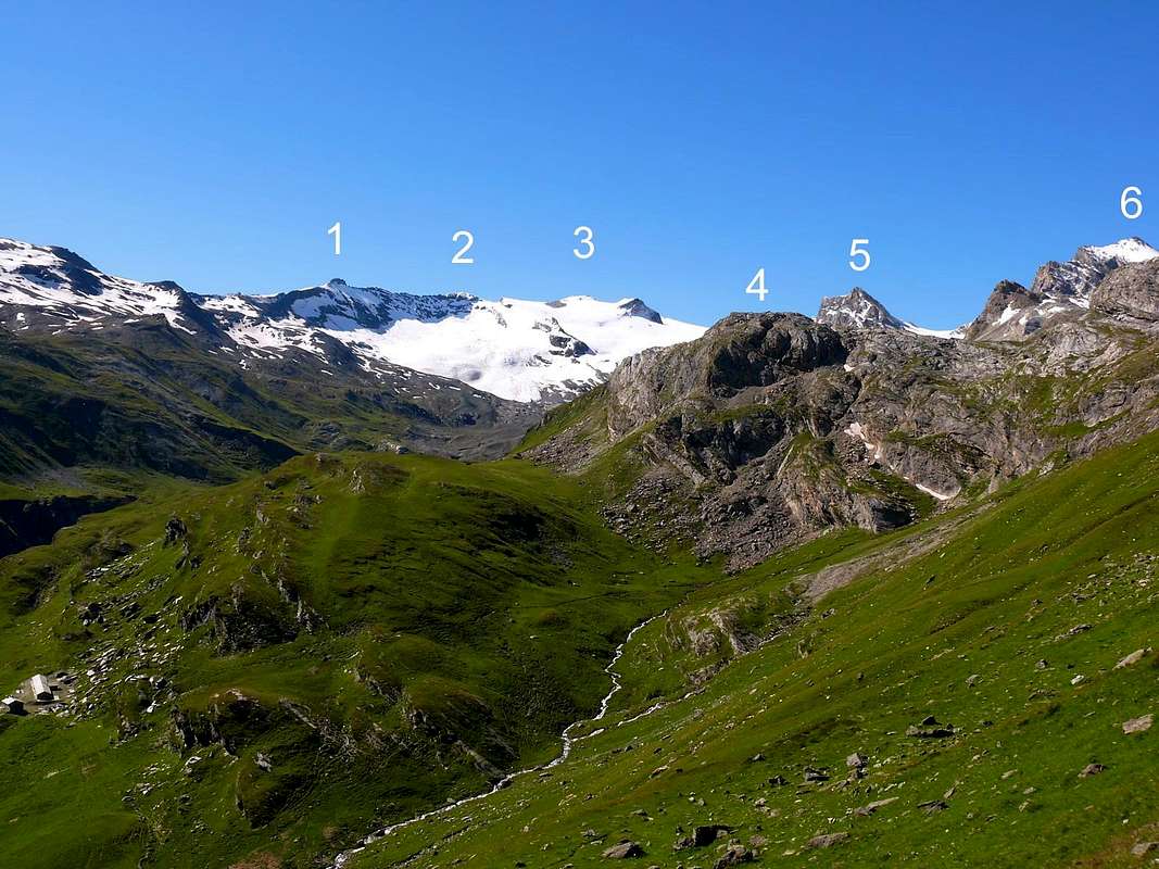
A) - On the Northern side, towards the PNGP (Gran Paradiso National Park) dominates the Western and Eastern Fond Glaciers (in the past calling them both of Lavassey, linking the same to this last place at the foot of the trio Punta Galisia/Punta Bousson/Punta Basei) with its great North Face; a trio of mountains with surprisingly similar characteristics to that of Roc de Basagne, Roc du Fond, Pointe Calabre with rocky slopes on the Eastern side and covered by ice on the Western side. While
B) - On the Southern or French side, towards the PNV (Vanoise National Park) imposes itself above those of Calabre (SO) and of Basagne (S-SE). And it is from these considerations in general that we pass to a more in-depth examination of the structure and morphology of this double mountain. Describing the structure of which and starting, in a clockwise direction, from the Western or, better, West-northwestern side we find
1) - A glacial slope which, from the extreme offshoots of the Glacier de Tsantelèine, covers the entire W-NW side adding the Summit NW (3.220m).
2) - An edge, interspersed with an ocher-yellow rocky jump at the upper end of an oblique downward band, at the Western edge of the North Wall acts as a divider with the previous slope, originating at an altitude of 2.750 meters approximately on the Glacier de Tsantelèine but better defined a hundred meters above.
3) - The North Wall flanks it showing its Western Side formed by broken rocks at the base followed by a kind of snowy-detrital channel which, in the shape of a convex to the West arch, reaches the rocks below the "castle" of the Top with a very challenging route even if formed by unnecessary passages (bypassable with some difficulty to the right or South).
4) - Beyond as well as to the left or East, almost the entire central body of the North Wall remains unexplored; both in the right sector (West) and in the opposite, from which it is separated by a large, almost vertical rocky pylon or, better, pillar and formed by a yellow-whitish rocky band in the middle and at the top by a reddish-brown rocky castle. On the extreme left corner of the face rises a slender and aerial edge, also still waiting for climbers.
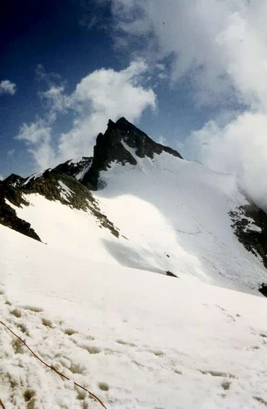
5) - Moving on to the Eastern sector, it is formed by a small triangular wall furrowed in the middle by a generally snowy gully, which climbs diagonally to the left towards the E-SE Crest (as can be clearly seen by observing from Punta Galisia, see below in "First Ascents" as the picture of july 1980, by Marco Cossard). The same is bounded on the left by the aforementioned crest and on the right by the above-mentioned aerial edge. Short but demanding climb (lacking a more detailed report it is assumed with passages up to the III°) which took three hours with an attack about fifty meters below the Col de Basagne on the Glacier de Fond Oriental, or rather to the North, then gradually converging to the left towards the border ridge.
6) - The Eastern Crest, or rather E-SE, "closes" everything that has something in common with Italy and the Aosta Valley: it rises from the aforementioned hill reaching Southeastern Top, or the higher of the two. Ascent with characteristics and technical difficulties similar to the East Wall consists of a steep greenish rock wall 70/5 meters high, in the initial phase, and then continues more or less along the ridge for a total of 115 meters approximately. It is worth mentioning the first climbers of September 1889 who are the formidable (you can find her everywhere) Alpine Guide of Rhêmes Notre Dame Casimiro Thérisod together with Giovanni Bobba, great mountaineer and mountain writer living in Turin, as well as author, together with Luigi Vaccarone, of "Guide of the Western Alps, 1896", a milestone in the history of mountaineering not only in Italy. The first exploration of these mountains certainly belongs to the two of them, as well as Luigi Vaccarone.
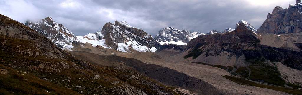
7) - Finally, the Southern or French side of which little or, better still, nothing is known, except that it consists of a long buttress pointing to the SW, designed to separate the glacier de Basagne (S-SE) from that of Fond (SO). To finish, after having formed the Altitude 3.129 meters, just above the Réfuge de Prariond (2.320 m). On these two sides (SE and SW) the respective glaciers rise up to lap the summit ridges, formed in the last stretch by debris flows inserted between very broken rocks. One more opportunity to go personally to visit and check which side you can go up ...
Ma anche montagna dall'aspetto di grande trapezio isoscele dalle linee perfettamente equilibrate, nonché posizionata sull'asse Sudest/Nordovest e circondata da ben quattro ghiacciai distinti:
A) - Sul lato Settentrionale, in direzione del PNGP (Parco Nazionale del Gran Paradiso) domina con la sua grande Parete Nord i Ghiacciai Occidentale ed Orientale del Fond (nei tempi passati chiamandoli entrambi di Lavassey accomunando gli stessi a questo ultimo posto ai piedi del trio Punta Galisia / Punta Bousson / Punta Basei); un trio di montagne dalle caratteristiche sorprendentemente similari a quello di Roc de Basagne, Roc du Fond, Pointe Calabre con versanti rocciosi sul lato Orientale e ricoperte dai ghiacci su quello Occidentale. Mentre
B) - Sul lato Meridionale o francese, verso il PNV (Parco Nazionale della Vanoise) si impone al di sopra di quelli di Calabre (SO) e di Basagne (S-SE). Ed é da queste considerazioni in generale che passiamo ad un più approfondito esame della struttura e della morfologia di questa duplice montagna. Descrivendo lastruttura della quale ed iniziando, in senso orario, dal Versante Occidentale o, meglio, Nordoccidentale troviamo
1) - Un pendio glaciale che, dalle estreme propaggini del Glacier de Tsantelèine, ricopre tutto il Versante O-NO aggiungendo la Sommità NO (3.220 m).
2) - Uno spigolo, inframmezzato da un salto roccioso giallo ocra al termine superiore di una fascia obliqua verso il basso, al margine Occidentale della Parete Nord fungente da divisorio col precedente versante, originandosi a quota 2.750 metri circa sul Glacier de Tsantelèine ma definendosi meglio un centinaio di metri sopra.
3) - La Parete Nord lo affianca mostrando il suo lato Occidentale formato da rocce rotte alla base seguite da una specie di canale nevoso-detritico che, a forma di arco convesso ad Ovest, raggiunge le rocce sottostanti la Vetta, impegnative e difficili anche se aggirabili, con qualche difficoltà, verso Meridione.
4) - Oltre nonché verso sinistra od Est, quasi tutto il corpo centrale della Parete Nord rimane inesplorato; sia nel settore di destra (Ovest) che nell'opposto, dal quale viene separato da un grande pilone, o se si preferisce pilastro, pressocché verticale e formato da una fascia rocciosa giallo-biancastra nel mezzo ed in alto da un castelletto roccioso bruno-rossiccio. Sul margine sinistro angolare della faccia sale uno spigolo slanciato ed areo, anche esso ancora in attesa di salitori.
5) - Passando al settore Orientale, esso é formato da una piccola parete triangolare solcata nel mezzo da un canalone in genere nevoso, che sale con diagonale a sinistra verso la Cresta E-SE (come ben si vede osservando dalla Punta Galisia, vedere in "First Ascents" vedi fotografia del luglio 1980, di Marco Cossard). La stessa é delimitata a sinistra dalla predetta cresta e sulla destra dallo spigolo aereo di cui prima. Breve ma impegnativa salita (mancando relazione più dettagliata si suppone con passaggi fino al III°) che richiese tre ore con attacco una cinquantina di metri al di sotto del Col de Basagne sul Glacier de Fond Oriental, ovvero a Settentrione, per poi gradualmente convergere a sinistra verso la cresta di frontiera.
6) - La Cresta Est, o meglio E-SE, "chiude" tutto ciò che ha in comune qualcosa con l'italia e la Valle d'Aosta: essa sale dal predetto colle raggiungendo la Cima SE, ovvero la più elevata delle due. Salita con caratterisiche e difficoltà tecniche analoghe alla Parete Est é costituita da un ripido muro di roccia verdastra alto 70/5 metri circa, nella fase iniziale, per poi continuare più o meno sul filo di cresta per un totale di 115 metri circa. Merita citare i salitori del settembre 1889 che sono la formidabile (la trovi dapperttutto) Guida Alpina di Rhêmes Notre Dame Casimiro Thérisod insieme a Giovanni Bobba, grande alpinista e letterato di montagna residente in Torino, nonché autore, insieme a Luigi Vaccarone, di "Guida delle Alpi Occidentali, 1896", pietra miliare nella storia dell'alpinismo non solo italiano. La prima esplorazione di queste montagne spetta certamente a loro due, nonché a Luigi Vaccarone.
7) - Per finire il Versante Meridionale o francese del quale poco o, meglio nulla si sa, se non che é costituito da un lungo contrafforte che si indirizza a SO, atto a separare il glacier de Basagne (S-SE) da quello di Fond (SO); per terminare, dopo aver formato la Quota 3.129 metri, appena al di sopra del Réfuge de Prariond (2.320 m). Su questi due versanti (SE e SO) i rispettivi ghiacciai salgono fino a lambire le creste sommitali, formate nell'ultimo tratto da colate detritiche inserite tra roccette molto rotte. un occasione in più per andare personalmente a visitare e controllare ...
First Ascents
First on the summit: Puisseux Brothers and Maginot, (Aug 21th, 1876).
In winter: Unknown.
Western Slope: Puisseux Brothers and Maginot, (Aug 21th, 1876); in ascent from Val d'Isère.
N-NO Corner (Yellow Edge Via ): Osvaldo Cardellina, solo, (Jul 20th, 1984) in ascent in day from Thumel, Benevolo Shelter, Source de la Doire, Lac de fond; in descent through Northwestern Slope.
N-NE Face (Couloir on Eastern Side and Est Crest in final part ): Osvaldo Cardellina and Alessandro Cardellina, (Aug 28th, 1993); in ascent in day from Thumel, Benevolo Shelter, Source de la Doire, Lac de Fond; in descent through Northwestern Slope.
N-NE Face (Direct Route on Western Side ): Osvaldo Cardellina, solo, (Sep 12th, 1998); in ascent and in day from Thumel, Benevolo Shelter; in descent NW Slope.
E Face: Ernesto, Lorenzo and Luigi Rossi di Montelera and Aosta's Mountain Guides Beniamino Henry and N. Oreiller, (Summer 1962); in ascent from Federico Benevolo Shelter.
E-SE Ridge: Giovanni Bobba with Rhêmes Notre Dame Mountain Guide Casimiro Thérisod, (Sep 21th, 1889); in ascent from Lavassey Pastures.
Getting There
From France: through the Mont Blanc Tunnel or the Col du Petit Saint Bernard: you can drive on SS.26, following directions for Aosta and, before arriving in Villeneuve, turn right towards Introd. Alternatively, you can take Motorway A5 (at Courmayeur or Morgex) and exit at Aosta Ovest.
From all the other directions: get to the Aosta Ovest exit of Motorway A5. Then drive on SS.26 Aosta, in the direction of Courmayeur; just after Villeneuve turn left towards Introd.
Enter the valley and, at the fork between Valsavarenche and Val di Rhêmes turn to the right (Rhêmes). Cross all the villages to arrive to Rhêmes Notre Dame and follow to Thumel (car parking), herefrom, following the dirt road on the right side (ascending) of the valley, or, better with snow, a track on the left that passing throught some fine woods leads you to the Rifugio Benevolo (2.285m).
Route
From Gian Federico Benevolo Refuge (2.285m) by path 13c and Southwest direction to small bridge (2.269m); to reach along Doire stream, West side, (Truc Saint Hélène Tour) to quota 2.465m. By traces to sources Doires stream's of Rhêmes and, through moraine route, to reach the Fond Lake (2.625m), the Central Fond Glacier and the Fond Pass (3.081m). From pass by "clapeys" and snow fields (30°/35°) to go up 150 meters to NW Point (3.220m); through easy rocks (yellow fine stone) to cross easily to South Point (3.228m)3h'00/3h'30.
Dal Rifugio Gian Federico Benevolo (2.285 m) con il sentiero 13c verso SW al piccolo ponte (2.269 m) e seguendo a Ovest la Dora di Rhêmes (Tour del Truc Saint Hélène) verso quota 2.465 m, ove termina tramutandosi in traccia esile. Con questa verso le sorgenti della Dora di Rhêmes e, con percorso su morena, raggiungere il Lago di Fond (2.625 m), il Ghiacciaio Centrale di Fond e l'omonimo Colle (3.081 m) Dal Colle tramite "clapeys" e pendii nevosi (30°/35°) risalire per circa 150 metri verso la Punta NW (3.220 m); per facili rocce di calcare giallo traversare facilmente alla Punta Sud (3.228 m)3h'00/3h'30.
Difficulty
This route can be considered EE/A, F.
L'itinerario è classificato EE/A, F.
Equipment
Standard mountaineering equipment. Rope, ice axe and crampons.
The Eastern side of the valley belongs to Gran Paradiso National park, the Western one is out of the boundaries of the Park ... but nature must be respected.
Campings
Remember that free camping is forbidden (except for emergency reasons, over 2.500m, from darkness until dawn).
Mountain Conditions
You can get meteo information at the official site of the Regione Valle d'Aosta:
Parents refers to a larger category under which an object falls. For example, theAconcagua mountain page has the 'Aconcagua Group' and the 'Seven Summits' asparents and is a parent itself to many routes, photos, and Trip Reports.

 6911 Hits
 86.37% Score
 22 Votes